
The 1800 United States presidential election was the fourth quadrennial presidential election. It was held from October 31 to December 3, 1800. In what is sometimes referred to as the "Revolution of 1800", Vice President Thomas Jefferson of the Democratic-Republican Party defeated incumbent President John Adams of the Federalist Party. The election was a political realignment that ushered in a generation of Democratic-Republican leadership.

Jefferson County is the most populous county in the U.S. state of Alabama, located in the central portion of the state. As of the 2010 census, its population was 658,466. Its county seat is Birmingham, the most populous city in the state. Its rapid growth as an industrial city in the 20th century, based on heavy manufacturing in steel and iron, established its dominance.

Jefferson County is an exurban county located in the U.S. state of Tennessee. As of the 2010 census, the population was 51,407. Its county seat is Dandridge.

Cole County is located in the central part of the U.S. state of Missouri. As of the 2010 census, the population was 75,990. Its county seat and largest city is Jefferson City, the state capital. The county was organized November 16, 1820 and named after pioneer Captain Stephen Cole, an Indian fighter and pioneer settler, who built Cole's Fort in Boonville.

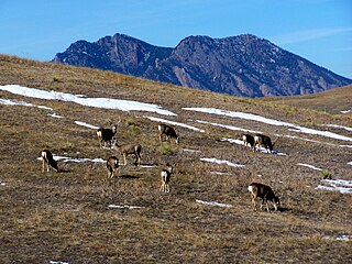
Jefferson County, is a county located in the U.S. state of Colorado. As of the 2010 census, the population was 534,543, making it the fourth-most populous county in Colorado. The county seat is Golden, and the most populous city is Lakewood.

The City of Arvada is a Home Rule Municipality located in Jefferson and Adams counties, Colorado, United States. Arvada is a part of the Denver–Aurora–Lakewood, CO Metropolitan Statistical Area. As of the 2010 census the population was 106,433, and in 2019 the estimated population was 121,272, ranking Arvada as the seventh most populous municipality in Colorado. The Olde Town Arvada historic district is 7 miles northwest of the Colorado State Capitol in Denver.

The City of Westminster is a Home Rule Municipality located in Jefferson and Adams counties, Colorado, United States. Westminster is a part of the Denver–Aurora–Lakewood, CO Metropolitan Statistical Area. The Westminster Municipal Center is located 9 miles (14 km) north-northwest of the Colorado State Capitol. As of the 2010 census the population of Westminster was 106,114, and as of 2019 the estimated population was 113,166. Westminster is the seventh most populous city in Colorado and the 237th most populous city in the United States. Westminster is a part of the Denver-Aurora-Lakewood, CO Metropolitan Statistical Area and the Denver-Aurora-Boulder Combined Statistical Area.

Superior is a Statutory Town in Boulder County in the U.S. state of Colorado, with a small, uninhabited segment of land area extending into Jefferson County. According to the 2010 census, the population of the city was 12,483.

Berlin Charter Township is a charter township of Monroe County in the U.S. state of Michigan. At the 2010 census, the township population was 9,299. Berlin Charter Township was organized from the northern portion of previously established Frenchtown Charter Township, and the township boundaries has been in place since 1867. As part of the Monroe Metropolitan Area, the township is also classified as part of the much larger Metro Detroit region.

Aztalan is a town in Jefferson County, Wisconsin, United States. The population was 1,457 at the 2010 census. The unincorporated communities of Aztalan and Jefferson Junction are located in the town.

The Louisville metropolitan area or Kentuckiana, also known as the Louisville–Jefferson County, Kentucky–Indiana, metropolitan statistical area, is the 45th largest metropolitan statistical area (MSA) in the United States. The principal city is Louisville, Kentucky.

The Eastern Panhandle is the eastern of the two panhandles in the U.S. state of West Virginia. It is a small stretch of territory in the northeast of the state, bordering Maryland and Virginia. Some sources and regional associations only identify the Eastern Panhandle as being composed of Morgan, Berkeley, and Jefferson counties. Berkeley and Jefferson counties are geographically located in the Shenandoah Valley. West Virginia is the only U.S. state with two panhandles; the other is the Northern Panhandle.
A flattop is a type of very short hairstyle.
Indian Island is an Unincorporated community in Jefferson County, Washington, United States. The whole island is covered by the Marrowstone CDP. It is located between Port Townsend Bay and Kilisut Harbor. Parts also border on Oak Bay and Scow Bay. Until the construction of the Port Townsend Ship Canal Indian Island was connected to the mainland by a broad sand flat and backshore marsh. Indian Island is the location of the Indian Island Naval Reserve, which covers the entire island. No civilian residences are allowed on Indian Island. Indian Island is attached to Marrowstone Island, and is often grouped with it. Indian Island is served by the ZIP code for Nordland. The entire island has a land area of 11.28 km2 and a population of 44 persons as of the 2000 census.
Table Mountain is a large flat-topped mountain overlooking Cape Town, South Africa.

South Table Mountain is a mesa on the eastern flank of the Front Range of the Rocky Mountains of North America. Castle Rock, the 6,338-foot (1,932 m) summit of the mesa, is located on private property 0.56 miles (0.9 km) directly east of downtown Golden, Colorado, United States, in Jefferson County.
The Rocky Flats National Wildlife Refuge is 5,237-acre (21.19 km2) National Wildlife Refuge in the United States, located approximately 16 miles (26 km) northwest of Denver, Colorado. The refuge is situated west of the cities of Broomfield and Westminster and situated north of the city of Arvada.
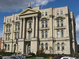
The Jefferson County Courthouse is located at 301 Market Street in Steubenville, Ohio. It is the original courthouse constructed for Jefferson County. It was constructed in 1871 through 1874 by Heard & Blythe architectural firm.

Flat Top Mountain is the highest summit of the Flat Tops in the Rocky Mountains of North America. The prominent 12,361-foot (3,768 m) peak is located in the Flat Tops Wilderness, 19.1 miles (30.7 km) south-southwest of the Town of Oak Creek, Colorado, United States, on the drainage divide between Routt National Forest and White River National Forest. The summit of Flat Top Mountain is the highest point in Garfield County, Colorado.

The Lyon County Courthouse is located in Rock Rapids, Iowa, United States. It was listed on the National Register of Historic Places in 1979. The courthouse is the second building the county has used for court functions and county administration.


