Floods in the United States before 1901

Last updated

Floods in the United States before 1901 is a list of flood events that were of significant impact to the country, before 1901. Floods are generally caused by excessive rainfall, excessive snowmelt, and dam failure.

Contents

Prehistoric events

Kankakee Torrent

The Kankakee Torrent was a catastrophic flood that occurred between 14,000 and 18,000 years ago, resulting from the breach of a large glacial lake formed by the melting of the Wisconsin Glacier. The origin of the flood may have been prehistoric Lake Chicago, it may have come from further east, near what is today the center of the Lower Peninsula of the state of Michigan. The torrent carved out a channel that is currently followed by the Kankakee River and Illinois River. It also appears to have pushed the course of the Ohio River further south and the Mississippi River further west. The bluffs carved by the torrent can be seen at Starved Rock State Park and Kankakee River State Park. In both parks, smaller streams flow over waterfalls before they join the main river, phenomenon known as hanging tributaries.

Glacial River Warren

Glacial River Warren drained Lake Agassiz in central North America through a series of floods about 9,700 years ago. The enormous outflow from this lake carved a broad valley now occupied by the much smaller Minnesota River and the Upper Mississippi River. Agassiz was a huge body of water, up to 600–700 feet (~200 m) deep, and at various times covering areas totaling over 110,000 square miles (~300,000 km2). [1] Blocked by an ice sheet to the north, the lake water rose until about 9,700 years ago, when it overtopped the Big Stone Moraine, a ridge of glacial drift left by the receding glacier, at the location of Browns Valley, Minnesota. The lake's outflow was catastrophic at times, [2] and carved a gorge through the moraine a mile (1.6 km) wide and 130 feet (~40 m) deep, which is now known as the Traverse Gap. [3] While active, Glacial River Warren cut and eroded a bed up to five miles (8 km) wide and 250 feet (80 m) deep. [4] This has left a valley which starts at Traverse Gap near Browns Valley, Minnesota, goes southeast to Mankato, then turns northeast to the Twin Cities.

Maumee Torrent

The Maumee Torrent was caused by the draining of glacial Lake Maumee, the ancestor of present-day Lake Erie. The flood carved a channel up to 2 miles wide, which today is the site of the Little River in Allen County, Indiana.

Missoula Floods

The Missoula Floods are a series of flood outbursts that took place near the end of the last ice age. Much of the unique geography of eastern Washington, named the Channeled Scablands, is thought to have been carved during this period. A glacial lake, located on the Clark Fork River in western Montana is thought to have been the source. The glacial lake outburst floods are thought to have been the result of periodic sudden ruptures of the ice dam on the Clark Fork River that created Glacial Lake Missoula. After each ice dam rupture, the waters of the lake would rush down the Clark Fork and the Columbia River, inundating much of eastern Washington and the Willamette Valley in western Oregon. After the rupture, the ice would reform, recreating Glacial Lake Missoula once again.

Bonneville Flood

The Bonneville Flood was a catastrophic flood 14,000 years ago, which involved massive amounts of water inundating parts of southern Idaho and Eastern Washington along the course of the Snake River. Unlike the Missoula Floods, which occurred during the same period, the Bonneville Flood happened only once. The flood is believed to be the second largest flood in known geologic history.

Sixteenth century

Flood of March 1543

Hernando DeSoto's party was passing through a village at the confluence of the Mississippi River and Arkansas River on March 18 when the rivers flooded. The high water only allowed passage by canoe and inundated fields surrounding the town. [5] The flooding reportedly lasted for 40 days. [6]

Seventeenth century

California Flood of 1605

The California Flood of 1605 was a flood that covered much of California.

Eighteenth century

New Hampshire flood – 1740

The Merrimack River flooded in December. It is the first recorded flood in New Hampshire history. [7]

New Hampshire/Maine flood – October 1785

In New Hampshire, a significant flood struck the Cocheco, Baker, Pemigewasset, Contoocook and Merrimack rivers on October 23 which established records at Lowell which held until 1902. [7] The Androscoggin River flooded significantly, which destroyed many homesteads in what would become Bethel, Maine. Those that survived the flood moved uphill into less valuable, 100-acre (0.40 km2) plots. Turner's first mill was destroyed during this inundation. [8]

Great Pumpkin flood – October 1786

Received its name due to the pumpkins that were washed away in the flood on October 5. It was a major flood in the Susquehanna River basin. [9]

Red River of the South flood – 1800

According to the Caddo tribe, a "great flood" moved down the river and reinforced the "Great Log Raft" on the river. This raft was a natural dam that increased water levels on some of the Red River tributaries. This process formed Caddo Lake. [10]

Early Nineteenth century

Androscoggin flood – 1806

A significant flood along the Androscoggin River destroyed the first dam built in the town of Turner, Maine. [8]

Androscoggin flood – 1811

River flood carries away the toll bridge in Durham, Maine. [8]

Androscoggin flood – 1814

A large flood of the river destroyed all the mills in Turner, Maine. [8]

Waterville, Maine Freshet – May 1832

This flood washed away a portion of the Ticonic bridge and the Redington saw mill in Waterville, Maine. [11]

Androscoggin Freshet – 1843

A flood along the Androscoggin swept the town of Jay's sawmill downstream. [8]

Great Flood of 1844

The Great Flood of 1844 is the biggest flood ever recorded on the Missouri River and Upper Mississippi River in terms of discharge. This flood was particularly devastating since the region had little or no levees at the time. Among the hardest hit were the Wyandot who lost 100 people in the diseases that occurred after the flood. The flood also is the highest recorded for the Mississippi River at St. Louis. After the flood, Congress in 1849 passed the Swamp Act providing land grants to build stronger levees. [12]

Androscoggin flood – 1846

A flood along the Androscoggin River carried away the bridge in Durham, Maine. This reinstituted ferry service across the river. [8]

Potomac flood of October 1847

A significant flood struck the Potomac basin, part of a major flood event which encompassed Pennsylvania, Ohio, Maryland, and Virginia. Damage along the C&O Canal was worst between lock #7 and Widewater, from Great Falls to Pennyfield Lock, Point of Rocks to Dam #4, and surrounding Dam #5. Damages to the canal for the year, which included another flood that November, totaled US$48,000 (1847 dollars). [13]

Sauvé's Crevasse – 1849

This was the last of the annual spring Mississippi River floods to swamp New Orleans.

Red River of the South flood – August 1849

A flood that appears to have been caused by a tropical cyclone led to the flood of record on the Red River of the South. This flood shifted the river to its present course, moving out of Natchitoches. A remnant of the river known as Cane River extends from Grand Ecore to Colfax. [10]

Late Nineteenth century

Midwest and Plains U.S. – 1851

The Flood of 1851 occurred after record-setting rainfalls across the U.S. Midwest and Plains from May to August, 1851. Hardest hit was the State of Iowa, where the city of Des Moines was virtually destroyed, with significant flooding extending to the Lower Mississippi River basin. Historical evidence suggest flooding occurred in the eastern Plains, from Nebraska to the Red River basin, but these areas were sparsely settled in 1851. Heavy rainfall also occurred in the Ohio River basin.

Northeast flood – April 1852

In New Hampshire, the Winnipesaukee, Pemigewasset, Contoocook, Blackwater and Ashuelot Rivers went into flood. The Merrimack River at Concord reached its highest levels in nearly 70 years. [7] A flood with higher waters than 1847 surged down the Potomac River. The worst damage was witnessed between Georgetown and Seneca, with breaches at the abutments of Dams 3 and 4 in Maryland, and Dam 6 in Virginia. Damage was estimated at US$80,000 (1852 dollars). [13]

Susquehanna River flood – September 1861

Torrential rain and a logjam initiated the flood at the Susquehanna on September 28. Debris in the flood waters swept the Keating railroad bridge away. Sinnemahoning cemeteries were flooded, and some of its bodies moved downstream. [9]

The Great Flood of 1862

The largest flood in the recorded history of Oregon, Nevada and California. It began in Oregon in November 1861 after weeks of continuous precipitation, flooding the communities on the Willamette River.

California

Beginning on December 24, 1861, it rained for almost four weeks. The largest flood in California's recorded history occurred from January 9–12, 1862. The entire Sacramento and San Joaquin Valleys were inundated for an extent of 400–480 km (250–300 mi), averaging 32 kilometres (20 mi) in breadth. The rain created an inland sea in Orange County, lasting about three weeks with water standing 1.3 metres (4 ft 3 in) deep up to 6 kilometres (3.7 mi) from the river. [14]

Nevada

Flooding began in December, 1861 in Carson Valley from a series of storms in the upper Carson River basin. By January 2, 1862, the town of Dayton and the area surrounding it had been flooded. Samuel Young of Aurora recorded in his diary that the snow and rain had fallen for twenty six days out of thirty since December 24, 1861.

Androscoggin River flood – 1863

A large flood along the river destroys the bridge in East Turner, Maine. [8]

Saxby Gale flooding – 1869

The combination of the extreme high tide and a hurricane on October 4–5 was dubbed the Saxby Gale. The resultant flooding set records on the East Coast of the United States. The Federal Emergency Management Agency (FEMA) named it a 100-year flood for the Schuylkill River in Philadelphia, cresting 2 feet (0.61 m) higher than Hurricane Agnes in 1972. [15] [16] Washington, DC, was also hit hard. [17]

Mill River flood – May 1874

It rained significantly on May 16, 1874 in western Massachusetts. The earthen dam suddenly gave way. A large section of the east bank of the Mill River slid away and was sent downstream. The dam's gatekeeper mounted a horse and rushed down the valley to warn Williamsburg of what was to come. The gatekeeper's wife watched from their cabin as the dam exploded upward. Four riders galloped down the valley as fast as possible to warn people of the oncoming flood. Some residents fled to higher ground, while others refused to believe the awful news. Many never heard the warning. A 6 metres (20 ft) tall flood swept everything away. Damage totaled US$1 million and 144 people died. [18]

Mill towns petitioned Boston for assistance. The legislators eventually granted $120,000 to rebuild bridges and roads, which set a precedent for a state government to provide direct assistance after a natural disaster. The disaster led to improvements in public safety. The Massachusetts legislature imposed standards for the construction, maintenance, and inspection of dams. Engineering of large-scale public projects had to meet state mandates. Engineers became academically-trained professionals. Four-fifths of the businesses in the Mill Valley were eventually rebuilt on their original locations. The mill owners gradually regained their financial standing and their place as pillars of society. Factories powered by the rushing Mill River continued to dominate life in the valley for another quarter century, until steam, and then electricity, replaced water power. [19]

Potomac flood of November 1877

Higher than the event in 1852 by several feet, this flood affected the whole length of the C&O Canal. Since Conococheague and Antietam Creeks were flooding as well, the worst damage was done to the middle of the canal. Damage totaled US$200,000 (1877 dollars). Navigation could not resume until the following April. A result of this flood was a telephone network being installed along the canal, which was, at the time, the longest telephone circuit in the world. [13]

The Great Flood of April 1881

The Great Flood of 1881 struck Omaha, Nebraska and Council Bluffs, Iowa between April 6 and 27, when waters began to recede. Causing millions of dollars in damage, it crested two feet higher than ever-before measured on the Missouri River. [20]

Ohio River flood – February 1884

The level of the Ohio River in Parkersburg, West Virginia reached 54 feet (16 m), about 34 feet (10 m) above its normal stage. [21]

The Ohio River crested in Cincinnati at 71.1 feet (21.7 m) on February 14. [22]

East Texas flood – May 1884

This significant flood affected the Neches, Angelina, and lower Sabine River basins. Record stages were set during this event, roughly 2–3 feet (or almost a meter) higher than records from the 1900s. [10]

Johnstown – 1889

In the nineteenth century, dams were maintained privately. The Conemaugh Dam was maintained by the South Fork Fishing and Hunting Club, and had been recently rebuilt in 1881. However, on May 31, 1889 after a night of heavy rain, the Conemaugh Dam broke and flooded the surrounding valley. [23] Damage was extraordinary, and the dam was never rebuilt. [24] Also known as the Conemaugh Calamity, after the name of the dam, this flood claimed 2,209 lives. [25] Five days after the event, Clara Barton and her doctors and nurses arrived in Johnstown to tend to the survivors. It took 5 years for the town to recover.

To the east, it was also a major flood for the Susquehanna and its tributaries. The towns of Renovo, Lock Haven, Williamsport, and Sunbury were severely damaged. [9] Damage was not limited to Pennsylvania, however. The flood eclipsed all previous records for water levels on the Potomac, which caused US$300,000 (1889 dollars) to the C&O Canal. The canal would not recover from this flood until 1891. [13]

Oil Creek Flood – 1892

Heavy rains resulted in dam failures, causing rapid flooding in the Oil Creek area of Pennsylvania, primarily affecting Titusville and Oil City. Tankers holding highly flammable benzeine were located along the banks of the creek. The tankers were uprooted and emptied as a result of the flooding, and their contents ignited, flooding the impacted areas with fire as well as water. 54 Oil City residents and 72 Titusville residents died either from the fire or the flood waters. [26]

Androscoggin flood – March 1896

A spring flood removed the East Turner bridge. [8]

See also

Related Research Articles

Missoula Floods Cataclysmic floods at the end of the last ice age, in eastern Washington state, US

The Missoula Floods refer to the cataclysmic floods that swept periodically across eastern Washington and down the Columbia River Gorge at the end of the last ice age. The glacial flood events have been researched since the 1920s. These glacial lake outburst floods were the result of periodic sudden ruptures of the ice dam on the Clark Fork River that created Glacial Lake Missoula. After each ice dam rupture, the waters of the lake would rush down the Clark Fork and the Columbia River, flooding much of eastern Washington and the Willamette Valley in western Oregon. After the rupture, the ice would reform, creating Glacial Lake Missoula again.

Lake Missoula Prehistoric proglacial lake in Western Montana

Lake Missoula was a prehistoric proglacial lake in western Montana that existed periodically at the end of the last ice age between 15,000 and 13,000 years ago. The lake measured about 7,770 square kilometres (3,000 sq mi) and contained about 2,100 cubic kilometres (500 cu mi) of water, half the volume of Lake Michigan.

Johnstown Flood Massive flood of Johnstown, Pennsylvania caused by the collapse of the South Fork Dam

The Johnstown Flood occurred on May 31, 1889, after the catastrophic failure of the South Fork Dam, located on the south fork of the Little Conemaugh River, 14 miles (23 km) upstream of the town of Johnstown, Pennsylvania. The dam broke after several days of extremely heavy rainfall, releasing 14.55 million cubic meters of water. With a volumetric flow rate that temporarily equaled the average flow rate of the Mississippi River, the flood killed more than 2,200 people and accounted for $17 million of damage.

Glacial Lake Wisconsin was a prehistoric proglacial lake that existed from approximately 18,000 to 14,000 years ago, at the end of the last ice age, in the central part of present-day Wisconsin in the United States.

In geomorphology, an outburst flood — a type of megaflood — is a high-magnitude, low-frequency catastrophic flood involving the sudden release of a large quantity of water. During the last deglaciation, numerous glacial lake outburst floods were caused by the collapse of either ice sheets or glaciers that formed the dams of proglacial lakes. Examples of older outburst floods are known from the geological past of the Earth and inferred from geomorphological evidence on Mars. Landslides, lahars, and volcanic dams can also block rivers and create lakes, which trigger such floods when the rock or earthen barrier collapses or is eroded. Lakes also form behind glacial moraines, which can collapse and create outburst floods.

Grand Coulee An ancient river bed in the U.S. state of Washington

The Grand Coulee is an ancient river bed in the U.S. state of Washington. This National Natural Landmark stretches for about 60 miles southwest from Grand Coulee Dam to Soap Lake, being bisected by Dry Falls into the Upper and Lower Grand Coulee.

Channeled Scablands Landscape in eastern Washington, USA scoured by cataclysmic floods during the Pleistocene epoch

The Channeled Scablands at one time were a relatively barren and soil-free region of interconnected relict and dry flood channels, coulees and cataracts eroded into Palouse loess and the typically flat-lying basalt flows that remain after cataclysmic floods within the southeastern part of the U.S. state of Washington. The channeled scablands were scoured by more than 40 cataclysmic floods during the Last Glacial Maximum and innumerable older cataclysmic floods over the last two million years. These cataclysmic floods were repeatedly unleashed when a large glacial lake repeatedly drained and swept across eastern Washington and down the Columbia River Plateau during the Pleistocene epoch. The last of the cataclysmic floods occurred between 18,200 and 14,000 years ago.

Livermore, Pennsylvania is an abandoned town that was located on the Conemaugh River between Blairsville and Saltsburg in Derry Township, Westmoreland County, Pennsylvania. The town was abandoned and partially razed in the early 1950s following authorization by the Flood Control Act of 1936 and Flood Control Act of 1938 for construction of the Conemaugh Dam and Lake to prevent flooding of Pittsburgh. Much of the former town site now lies under the reservoir and floodplains.

Glacial lake outburst flood A type of outburst flood that occurs when the dam containing a glacial lake fails

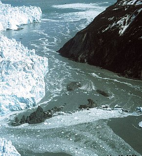
A glacial lake outburst flood (GLOF) is a type of outburst flood that occurs when the dam containing a glacial lake fails. An event similar to a GLOF, where a body of water contained by a glacier melts or overflows the glacier, is called a Jökulhlaup. The dam can consist of glacier ice or a terminal moraine. Failure can happen due to erosion, a buildup of water pressure, an avalanche of rock or heavy snow, an earthquake or cryoseism, volcanic eruptions under the ice, or if a large enough portion of a glacier breaks off and massively displaces the waters in a glacial lake at its base.

Floods in the United States are generally caused by excessive rainfall, excessive snowmelt, and dam failure. Below is a list of flood events that were of significant impact to the country, 1901 through 2000, inclusive.

Geology of Minnesota

The geology of Minnesota comprises the rock, minerals, and soils of the U.S. state of Minnesota, including their formation, development, distribution, and condition.

Lake Lewis lake in United States of America

Lake Lewis was a temporary lake in the Pacific Northwest region of North America, largely formed by the Missoula Floods in about the 14th millennium B.C.

Drumheller Channels National Natural Landmark Example in the Columbia Plateau of basalt butte-and-basin Channeled Scablands

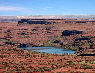
Drumheller Channels National Natural Landmark showcases the Drumheller Channels, which are the most significant example in the Columbia Plateau of basalt butte-and-basin Channeled Scablands. This National Natural Landmark is an extensively eroded landscape, located in south central Washington state characterized by hundreds of isolated, steep-sided hills (buttes) surrounded by a braided network of numerous channels, all but one of which are currently dry. It is a classic example of the tremendous erosive powers of extremely large floods such as those that reformed the Columbia Plateau volcanic terrain during the late Pleistocene glacial Missoula Floods.

Presumpscot River river in the United States of America

The Presumpscot River is a 25.8-mile-long (41.5 km) river located in Cumberland County, Maine. It is the main outlet of Sebago Lake. The river provided an early transportation corridor with reliable water power for industrial development of the city of Westbrook and the village of South Windham.

Crab Creek

Crab Creek is a stream in the U.S. state of Washington. Named for the presence of crayfish, it is one of the few perennial streams in the Columbia Basin of central Washington, flowing from the northeastern Columbia River Plateau, roughly 5 km (3.1 mi) east of Reardan, west-southwest to empty into the Columbia River near the small town of Beverly. Its course exhibits many examples of the erosive powers of extremely large glacial Missoula Floods of the late Pleistocene, which scoured the region. In addition, Crab Creek and its region have been transformed by the large-scale irrigation of the Bureau of Reclamation's Columbia Basin Project (CBP), which has raised water table levels, significantly extending the length of Crab Creek and created new lakes and streams.

Glacial River Warren, also known as River Warren, was a prehistoric river that drained Lake Agassiz in central North America between about 13,500 and 10,650 BP calibrated years ago. A part of the uppermost portion of the river channel was designated a National Natural Landmark in 1966.

Proglacial lakes of Minnesota

The proglacial lakes of Minnesota were lakes created in what is now the U.S. state of Minnesota in central North America in the waning years of the last glacial period. As the Laurentide Ice Sheet decayed at the end of the Wisconsin glaciation, lakes were created in depressions or behind moraines left by the glaciers. Evidence for these lakes is provided by low relief topography and glaciolacustrine sedimentary deposits. Not all contemporaneous, these glacial lakes drained after the retreat of the lobes of the ice sheets that blocked their outlets, or whose meltwaters fed them. There were a number of large lakes, one of which, Glacial Lake Agassiz, was the largest body of freshwater known to have existed on the North American continent; there were also dozens of smaller and more transitory lakes filled from glacial meltwater, which shrank or dried as the ice sheet retreated north.

Lake Condon was a temporary lake in the Pacific Northwest region of North America, formed periodically by the Missoula Floods from 15,000 to 13,000 BC.

Bonneville flood catastrophic flooding event in the last ice age

The Bonneville flood was a catastrophic flooding event in the last ice age, which involved massive amounts of water inundating parts of southern Idaho and eastern Washington along the course of the Snake River. Unlike the Missoula Floods, which also occurred during the same period in the Pacific Northwest, the Bonneville flood only happened once. The flood is believed to be the second largest in known geologic history.

Kankakee Torrent

The Kankakee Torrent was a catastrophic flood that occurred about 19,000 BP calibrated years ago in the Midwestern United States. It resulted from a breach of moraines forming a large glacial lake fed by the melting of the Late Wisconsin Laurentide Ice Sheet. The point of origin of the flood was Lake Chicago. The landscape south of Chicago still shows the effects of the torrent, particularly at Kankakee River State Park and on the Illinois River at Starved Rock State Park.

References

  1. Lusardi, Quaternary Glacial Geology Archived February 3, 2007, at the Wayback Machine , pp. 3–4; Sansome, Minnesota Underfoot, p. 175. The area actually inundated at one time was somewhat less.
  2. Fisher, River Warren Boulders Archived July 20, 2011, at the Wayback Machine , pp. 348, 350.
  3. Sansome, Minnesota Underfoot, pp. 174–75; Upham, The Glacial Lake Agassiz Archived January 21, 2001, at the Wayback Machine , p. 14-17.
  4. Sansome, Minnesota Underfoot, pp. 118–19.
  5. Brad Edmondson. 1927 Mississippi River flood. Retrieved on 2006-11-30.
  6. World Meteorological Organization. The Associated Programme on flood Management. Retrieved on 2006-11-30.
  7. 1 2 3 NewHampshire.com NH floods. Archived August 12, 2007, at the Wayback Machine Retrieved on 2007-05-05.
  8. 1 2 3 4 5 6 7 8 Environmental History of the Androscoggin River, Maine and New Hampshire
  9. 1 2 3 Stephen F. Miller Jr. The Chronological History of Natural Disasters in North Central Pennsylvania. Retrieved on 2006-11-30.
  10. 1 2 3 WFO SHV – Hydrology Information
  11. The History of Waterville, Maine
  12. Jackson County 175th Anniversary Timeline Archived December 17, 2010, at the Wayback Machine
  13. 1 2 3 4 Potomac Riverkeeper – flood History Archived October 8, 2007, at the Wayback Machine
  14. "Historic Rainstorms in California". California Department of Water Resources. Archived from the original on August 24, 2007. Retrieved October 23, 2007.
  15. "Philadelphia, PA area Storm and flood, Oct 1869". Archived from the original on December 25, 2008. Retrieved June 1, 2009.
  16. Placard at Fairmount Waterworks
  17. "Washington, DC Storm and flood, Oct 1869". Archived from the original on October 2, 2011. Retrieved June 1, 2009.
  18. NESEC – floods Archived August 11, 2006, at the Wayback Machine
  19. Mass Moments: Dam Breaks, Causing Catastrophic flood
  20. "Historic floods on the Missouri River Fighting the Big Muddy in Nebraska" Archived June 3, 2008, at the Wayback Machine , Nebraska Department of Natural Resources. Retrieved March 31, 2008.
  21. The City of Parkersburg, West Virginia | flood History Archived April 23, 2007, at the Wayback Machine
  22. Yoder, Robert (2005). Newport in Vintage Postcards. Arcadia Publishing. p. 25. ISBN   978-0-7385-1812-1.
  23. Johnstown flood of 1889 – Historic
  24. Johnstown flood National Memorial (U.S. National Park Service)
  25. A Comparison of Drought, floods, and Hurricanes in the US
  26. "125th Anniversary of the Oil Creek Flood".