Missoula Floods

Last updated
Missoula Floods
Wpdms nasa topo missoula floods.jpg
Glacial Lake Columbia (west) and Glacial Lake Missoula (east) are shown south of Cordilleran Ice Sheet. The areas inundated in the Columbia and Missoula floods are shown in red.
DateBetween 15,000 and 13,000 years ago
LocationThe current states of:
Idaho, Washington and Oregon
CauseIce dam ruptures

The Missoula Floods (also known as the Spokane Floods or the Bretz Floods) refer to the cataclysmic floods that swept periodically across eastern Washington and down the Columbia River Gorge at the end of the last ice age. The glacial flood events have been researched since the 1920s. These glacial lake outburst floods were the result of periodic sudden ruptures of the ice dam on the Clark Fork River that created Glacial Lake Missoula. After each ice dam rupture, the waters of the lake would rush down the Clark Fork and the Columbia River, flooding much of eastern Washington and the Willamette Valley in western Oregon. After the rupture, the ice would reform, creating Glacial Lake Missoula again.

Contents

During the last deglaciation that followed the end of the Last Glacial Maximum, geologists estimate that a cycle of flooding and reformation of the lake lasted an average of 55 years and that the floods occurred several times over the 2,000-year period between 15,000 and 13,000 years ago. U.S. Geological Survey hydrologist Jim O'Connor and Spanish Center of Environmental Studies scientist Gerard Benito have found evidence of at least twenty-five massive floods, the largest discharging ≈10 cubic kilometers per hour (2.7 million m³/s, 13 times the Amazon River). [1] Alternate estimates for the peak flow rate of the largest flood include 17 cubic kilometers per hour [2] and range up to 60 cubic kilometers per hour. [3] The maximum flow speed approached 36 meters/second (130 km/h or 80 mph). [2]

Within the Columbia River drainage basin, detailed investigation of the Missoula floods' glaciofluvial deposits, informally known as the Hanford formation, has documented the presence of Middle and Early Pleistocene Missoula flood deposits within the Othello Channels, Columbia River Gorge, Channeled Scabland, Quincy Basin, Pasco Basin, and the Walla Walla Valley. Based on the presence of multiple interglacial calcretes interbedded with flood deposits, magnetostratigraphy, optically stimulated luminescence dating, and unconformity truncated clastic dikes, it has been estimated that the oldest of the Pleistocene Missoula floods happened before 1.5 million years ago. Because of the fragmentary nature of older glaciofluvial deposits, which have been largely removed by subsequent Missoula floods, within the Hanford formation, the exact number of older Missoula floods, which are known as Ancient Cataclysmic Floods, that occurred during the Pleistocene cannot be estimated with any confidence. [4] [5]

Flood hypothesis proposed

The Channeled Scablands of eastern Washington Giant ripple marks.jpg
The Channeled Scablands of eastern Washington

Geologist J Harlen Bretz first recognized evidence of the catastrophic floods, which he called the Spokane Floods, in the 1920s. He was researching the Channeled Scablands in Eastern Washington, the Columbia Gorge, and the Willamette Valley of Oregon. In the summer of 1922, and for the next seven years, Bretz conducted field research of the Columbia River Plateau. He had been interested in unusual erosion features in the area since 1910 after seeing a newly published topographic map of the Potholes Cataract. Bretz coined the term Channeled Scablands in 1923 to refer to the area near the Grand Coulee, where massive erosion had cut through basalt deposits. Bretz published a paper in 1923, arguing that the Channeled Scablands in Eastern Washington were caused by massive flooding in the distant past.

Bretz's view, which was seen as arguing for a catastrophic explanation of the geology, ran against the prevailing view of uniformitarianism, and Bretz's views were initially disregarded. The Geological Society of Washington, D.C, invited the young Bretz to present his previously published research at a January 12, 1927 meeting where several other geologists presented competing theories. Another geologist at the meeting, J.T. Pardee, had worked with Bretz and had evidence of an ancient glacial lake that lent credence to Bretz's theories. Bretz defended his theories, and this kicked off an acrimonious 40-year debate over the origin of the Scablands. Both Pardee and Bretz continued their research over the next 30 years, collecting and analyzing evidence that led them to identify Lake Missoula as the source of the Spokane Flood and creator of the Channeled Scablands. [6] [7]

After Pardee studied the canyon of the Flathead River, he estimated that flood waters in excess of 45 miles per hour (72 km/h) would be required to roll the largest of the boulders moved by the flood. He estimated the water flow was nine cubic miles per hour, more than the combined flow of every river in the world. [8] Estimates place the flow rate at ten times the flow of all current rivers combined. [2]

The Missoula Floods have also been referred to as the Bretz Floods in honor of Bretz. [3]

Flood initiation

Cordilleran Ice Sheet
maximum extent of Glacial Lake Missoula (eastern) and Glacial Lake Columbia (western)
areas swept by Missoula and Columbia floods Map missoula floods.gif
  Cordilleran Ice Sheet
  maximum extent of Glacial Lake Missoula (eastern) and Glacial Lake Columbia (western)
  areas swept by Missoula and Columbia floods

As the depth of the water in Lake Missoula increased, the pressure at the bottom of the ice dam increased enough to lower the freezing point of water below the temperature of the ice forming the dam. This allowed liquid water to seep into minuscule cracks present in the ice dam. Over a period of time, the friction from water flowing through these cracks generated enough heat to melt the ice walls and enlarge the cracks. This allowed more water to flow through the cracks, generating more heat, allowing even more water to flow through the cracks. This feedback cycle eventually weakened the ice dam so much that it could no longer support the pressure of the water behind it, and it failed catastrophically. [9] This process is known as a glacial lake outburst flood, and many such events have occurred in recorded history.

Flood events

As the water emerged from the Columbia River gorge, it backed up again at the 1 mile (1.6 km) wide narrows near Kalama, Washington. Some temporary lakes rose to an elevation of more than 400 ft (120 m), flooding the Willamette Valley to Eugene, Oregon and beyond. Iceberg rafted glacial erratics and erosion features are evidence of these events. Lake-bottom sediments deposited by the floods have contributed to the agricultural richness of the Willamette and Columbia Valleys. Glacial deposits overlaid with centuries of windblown sediments (loess) have scattered steep, southerly-sloping dunes throughout the Columbia Valley, ideal conditions for orchard and vineyard development at higher latitudes.

After analysis and controversy, geologists now believe that there were 40 or more separate floods, although the exact source of the water is still being debated. The peak flow of the floods is estimated to be 40 to 60 cubic kilometers per hour (9.5 to 15 cubic miles per hour). [2] [3] The maximum flow speed approached 36 meters/second (130 km/h or 80 mph). [2] Up to 1.9×10¹⁹ joules of potential energy were released by each flood (the equivalent of 4,500 megatons of TNT). [3] The cumulative effect of the floods was to excavate 210 cubic kilometres (50 cu mi) of loess, sediment and basalt from the Channeled Scablands of eastern Washington and to transport it downstream. [3]

Multiple flood hypothesis

During the ice age floods, Dry Falls was under 300 feet (91 m) of water approaching at a speed of 65 miles per hour (105 km/h). Dry Falls WA.jpg
During the ice age floods, Dry Falls was under 300 feet (91 m) of water approaching at a speed of 65 miles per hour (105 km/h).

The multiple flood hypothesis was first proposed by R.B. Waitt, Jr. in 1980. Waitt argued for a sequence of multiple floods — 40 or more. [11] [12] [13] Waitt's proposal was based mainly on analysis from glacial lake bottom deposits in Ninemile Creek and the flood deposits in Burlingame Canyon. His most compelling argument for separate floods was that the Touchet bed deposits from two successive floods were found to be separated by two layers of volcanic ash (tephra) with the ash separated by a fine layer of windblown dust deposits, located in a thin layer between sediment layers ten rhythmites below the top of the Touchet beds. The two layers of volcanic ash are separated by 1–10 centimetres (0.4–3.9 in) of airborne nonvolcanic silt. The tephra is Mount St. Helens ash that fell in Eastern Washington. By analogy, since there were 40 layers with comparable characteristics at Burlingame Canyon, Waitt argued they all could be considered to have similar separation in deposition time. [13]

Controversy over number and source of floods

The controversy whether the Channeled Scabland landforms were formed mainly by multiple periodic floods, or by a single grand-scale cataclysmic flood from late Pleistocene Glacial Lake Missoula or from an unidentified Canadian source, continued through 1999. [14] Shaw's team of geologists reviewed the sedimentary sequences of the Touchet beds and concluded that the sequences do not automatically imply multiple floods separated by decades or centuries. Rather, they proposed that sedimentation in the Glacial Lake Missoula basin was the result of jökulhlaups draining into Lake Missoula from British Columbia to the north. Further, Shaw's team proposed the scabland flooding might have partially originated from an enormous subglacial reservoir that extended over much of central British Columbia, particularly including the Rocky Mountain Trench, which may have discharged by several paths, including one through Lake Missoula. This discharge, if occurring concurrently with the breach of the Lake Missoula ice dam, would have provided significantly larger volumes of water. Further, Shaw and team proposed that the rhythmic Touchet beds are the result of multiple pulses, or surges, within a single larger flood. [14]

Glacial Lake Missoula high-water mark, 4200 ft., near Missoula, MT Glacial lake missoula high water mark rock 4200 ft.jpg
Glacial Lake Missoula high-water mark, 4200 ft., near Missoula, MT

In 2000, a team led by Komatsu simulated the floods numerically with a 3-dimensional hydraulic model. They based the Glacial Lake Missoula discharge rate on the rate predicted for the Spokane ValleyRathdrum Prairie immediately downstream of Glacial Lake Missoula, for which a number of previous estimates had placed the maximum discharge of 17 × 106m3/s and total amount of water discharged equal to the maximum estimated volume of Lake Missoula (2184 km3). Neglecting erosion effects, their simulated water flow was based on modern-day topography. Their major findings were that the calculated depth of water in each flooded location except for the Spokane Valley–Rathdrum Prairie was shallower than the field evidence showed. For example, their calculated water depth at the Pasco Basin–Wallula Gap transition zone is about 190 m, significantly less than the 280–300 m flood depth indicated by high-water marks. They concluded that a flood of ~106m3/s could not have made the observed high-water marks. [15]

In comment on the Komatsu analysis, Atwater's team observed that there is substantial evidence for multiple large floods, including evidence of mud cracks and animal burrows in lower layers which were filled by sediment from later floods. Further, evidence for multiple flood flows up side arms of Glacial Lake Columbia spread over many centuries have been found. They also pointed out that the discharge point from Lake Columbia varied with time, originally flowing across the Waterville Plateau into Moses Coulee but later, when the Okanagon lobe blocked that route, eroding the Grand Coulee to discharge there as a substantially lower outlet. The Komatsu analysis does not evaluate the impact of the considerable erosion observed in this basin during the flood (or floods) – hence the assumption that the flood hydraulics can be modeled using modern-day topography is an area which warrants further consideration – earlier narrower constrictions at places such as Wallula Gap and through the Columbia Gorge could be expected to produce higher flow resistance and correspondingly higher floods. [16]

The current understanding

The dating for Waitt's proposed separation of layers into sequential floods has been supported by subsequent paleomagnetism studies, which supports a 30–40 year interval between depositions of Mount St. Helens’ ash, and hence flood events, but do not preclude an up to 60 year interval. [9] Offshore deposits on the bed of the Pacific at the mouth of the Columbia River include 120 meters of material deposited over a several thousand-year period that corresponds to the period of multiple scabland floods seen in the Touchet Beds. Based on Waitt's identification of 40 floods, this would give an average separation between floods of 50 years. [17]

See also

Related Research Articles

Lake Missoula Prehistoric proglacial lake in Western Montana

Lake Missoula was a prehistoric proglacial lake in western Montana that existed periodically at the end of the last ice age between 15,000 and 13,000 years ago. The lake measured about 7,770 square kilometres (3,000 sq mi) and contained about 2,100 cubic kilometres (500 cu mi) of water, half the volume of Lake Michigan.

Proglacial lake A lake formed either by the damming action of a moraine during the retreat of a melting glacier, a glacial ice dam, or by meltwater trapped against an ice sheet

In geology, a proglacial lake is a lake formed either by the damming action of a moraine during the retreat of a melting glacier, a glacial ice dam, or by meltwater trapped against an ice sheet due to isostatic depression of the crust around the ice. At the end of the last ice age about 10,000 years ago, large proglacial lakes were a widespread feature in the northern hemisphere.

In geomorphology, an outburst flood — a type of megaflood — is a high-magnitude, low-frequency catastrophic flood involving the sudden release of a large quantity of water. During the last deglaciation, numerous glacial lake outburst floods were caused by the collapse of either ice sheets or glaciers that formed the dams of proglacial lakes. Examples of older outburst floods are known from the geological past of the Earth and inferred from geomorphological evidence on Mars. Landslides, lahars, and volcanic dams can also block rivers and create lakes, which trigger such floods when the rock or earthen barrier collapses or is eroded. Lakes also form behind glacial moraines, which can collapse and create outburst floods.

Grand Coulee An ancient river bed in the U.S. state of Washington

The Grand Coulee is an ancient river bed in the U.S. state of Washington. This National Natural Landmark stretches for about 60 miles southwest from Grand Coulee Dam to Soap Lake, being bisected by Dry Falls into the Upper and Lower Grand Coulee.

Channeled Scablands Landscape in eastern Washington, USA scoured by cataclysmic floods during the Pleistocene epoch

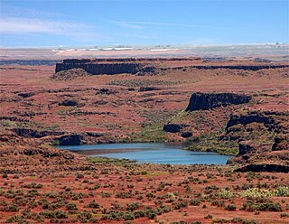
The Channeled Scablands at one time were a relatively barren and soil-free region of interconnected relict and dry flood channels, coulees and cataracts eroded into Palouse loess and the typically flat-lying basalt flows that remain after cataclysmic floods within the southeastern part of the U.S. state of Washington. The channeled scablands were scoured by more than 40 cataclysmic floods during the Last Glacial Maximum and innumerable older cataclysmic floods over the last two million years. These cataclysmic floods were repeatedly unleashed when a large glacial lake repeatedly drained and swept across eastern Washington and down the Columbia River Plateau during the Pleistocene epoch. The last of the cataclysmic floods occurred between 18,200 and 14,000 years ago.

J Harlen Bretz geologist

J Harlen Bretz was an American geologist, best known for his research that led to the acceptance of the Missoula Floods and for his work on caves. He was born to Oliver Joseph Bretz and Rhoda Maria Howlett, farmers in Saranac, Michigan, the oldest of five children. He earned a degree in biology from Albion College in 1905, where he also met his wife Fanny Chalis. Thereafter, he became interested in the geology of Eastern Washington state.

Dry Falls Scalloped precipice with four major alcoves, in central Washington scablands

Dry Falls is a 3.5-mile-long (5,600 m), 5.5 km in width, scalloped precipice with four major alcoves, in central Washington scablands. This cataract complex is on the opposite side of the Upper Grand Coulee from the Columbia River, and at the head of the Lower Grand Coulee, northern end of Lenore Canyon. According to the current geological model, catastrophic flooding channeled water at 65 miles per hour through the Upper Grand Coulee and over this 400-foot (120 m) rock face at the end of the last ice age. It is estimated that the falls were five times the width of Niagara, with ten times the flow of all the current rivers in the world combined.

Diluvium Deposits created as a result of catastrophic outbursts of Pleistocene giant glacier-dammed lakes

Historically, diluvium was a term in geology for superficial deposits formed by flood-like operations of water, and so contrasted with alluvium or alluvial deposits formed by slow and steady aqueous agencies. The term was formerly given to the boulder clay deposits, which some early geologists supposed had been caused by the Noachian deluge, a concept known as flood geology or diluvialism.

Glacial lake outburst flood A type of outburst flood that occurs when the dam containing a glacial lake fails

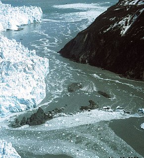
A glacial lake outburst flood (GLOF) is a type of outburst flood that occurs when the dam containing a glacial lake fails. An event similar to a GLOF, where a body of water contained by a glacier melts or overflows the glacier, is called a Jökulhlaup. The dam can consist of glacier ice or a terminal moraine. Failure can happen due to erosion, a buildup of water pressure, an avalanche of rock or heavy snow, an earthquake or cryoseism, volcanic eruptions under the ice, or if a large enough portion of a glacier breaks off and massively displaces the waters in a glacial lake at its base.

Joseph Pardee American geologist

Joseph T. Pardee was a U.S. geologist who worked for the U.S. Geological Survey, and contributed to the understanding of the origin of the Channeled Scablands. He discovered the trail of evidence left by Glacial Lake Missoula, a lake created by an ice dam 23 miles (37 km) wide and 0.5 miles (0.8 km) high during the most recent ice age. He discovered that when the dam broke, the water flowed towards the scablands, supporting J Harlen Bretz's theory of the cataclysmic floods.

Touchet Formation geological formation

The Touchet Formation or Touchet beds consist of large quantities of gravel and fine sediment which overlay almost a thousand meters of volcanic basalt of the Columbia River Basalt Group in south-central Washington and north-central Oregon. The beds consist of between 6 and 40 distinct rhythmites – horizontal layers of sediment, each clearly demarcated from the layer below. These Touchet beds are often covered by windblown loess soils which were deposited later; the number of layers varies with location. The beds vary in depth from 330 ft (100 m) at lower elevations where a number of layers can be found to a few extremely thin layers at the maximum elevation where they are observed.

Lake Lewis lake in United States of America

Lake Lewis was a temporary lake in the Pacific Northwest region of North America, largely formed by the Missoula Floods in about the 14th millennium B.C.

Drumheller Channels National Natural Landmark Example in the Columbia Plateau of basalt butte-and-basin Channeled Scablands

Drumheller Channels National Natural Landmark showcases the Drumheller Channels, which are the most significant example in the Columbia Plateau of basalt butte-and-basin Channeled Scablands. This National Natural Landmark is an extensively eroded landscape, located in south central Washington state characterized by hundreds of isolated, steep-sided hills (buttes) surrounded by a braided network of numerous channels, all but one of which are currently dry. It is a classic example of the tremendous erosive powers of extremely large floods such as those that reformed the Columbia Plateau volcanic terrain during the late Pleistocene glacial Missoula Floods.

Moses Coulee A canyon in the Waterville plateau region of Douglas County, Washington

Moses Coulee is a canyon in the Waterville plateau region of Douglas County, Washington. Moses Coulee is the second-largest and westernmost canyon of the Channeled Scablands, located about 30 kilometres (19 mi) to the west of the larger Grand Coulee. This water channel is now dry, but during glacial periods, large outburst floods with discharges greater than 600,000 m3/s (21,000,000 cu ft/s) carved the channel. While it's clear that megafloods from Glacial Lake Missoula passed through and contributed to the erosion of Moses Coulee, the origins of the coulee are less clear. Some researchers propose that floods from glacial Lake Missoula formed Moses Coulee, while others suggest that subglacial floods from the Okanogan Lobe incised the canyon. The mouth of Moses Coulee discharges into the Columbia River.

Umtanum Ridge Water Gap geologic feature in Washington, United States

Umtanum Ridge Water Gap is a geologic feature in central Washington state in the United States. It was designated a National Natural Landmark in 1980.

Ice Age Floods National Geologic Trail

The Ice Age Floods National Geologic Trail or Ice Age Floods Trail is designated as the first National Geologic Trail in the United States. It will consist of a network of routes connecting facilities that will provide interpretation of the geological consequences of the Glacial Lake Missoula floods of the last glacial period that began about 110,000 years ago.

Lake Condon was a temporary lake in the Pacific Northwest region of North America, formed periodically by the Missoula Floods from 15,000 to 13,000 BC.

Glacial Lake Columbia

Glacial Lake Columbia was the lake formed on the ice-dammed Columbia River behind the Okanogan lobe of the Cordilleran Ice Sheet when the lobe covered 500 square miles (1,300 km2) of the Waterville Plateau west of Grand Coulee in central Washington state during the Wisconsin glaciation. Lake Columbia was a substantially larger version of the modern-day lake behind the Grand Coulee Dam. Lake Columbia's overflow – the diverted Columbia River – drained first through Foster Coulee, and as the ice dam grew, through first Moses Coulee, and finally, the Grand Coulee.

Giant current ripples Depositional forms in diluvial plain and mountain scablands

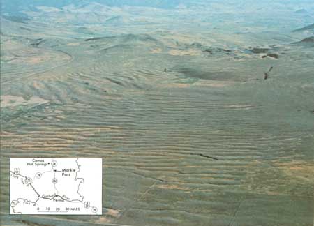
Giant current ripples are active channel topographic forms up to 20 m high, which develop within near-talweg areas of the main outflow valleys created by glacial lake outburst floods. Giant current ripple marks are morphologic and genetic macroanalogues of small current ripples formed in sandy stream sediments.

Altai flood The cataclysmic floods that swept along the Katun River in the Altai Republic at the end of the last ice age

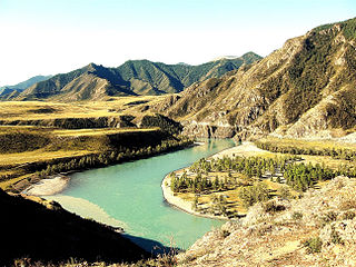
The Altai flood refers to the cataclysmic flood(s) that, according to some geomorphologists, swept along the Katun River in the Altai Republic at the end of the last ice age. These glacial lake outburst floods were the result of periodic sudden ruptures of ice dams like those triggering the Missoula floods.

References

  1. "Science writer Richard Hill gives a brief geologic history of the Columbia River Gorge". The Oregonian. Archived from the original on 2008-08-04. Retrieved 2008-06-15.
  2. 1 2 3 4 5 Bjornstad, Bruce N. (c. 2006). On the trail of the Ice Age floods : a geological field guide to the mid-Columbia basin / Bruce Bjornstad. Sandpoint, Idaho: Keokee Books. p. 2. ISBN   978-1-879628-27-4.
  3. 1 2 3 4 5 Allen, John Eliot; Burns, Marjorie; Sargent, Sam C. (c. 1986). Cataclysms on the Columbia : a layman's guide to the features produced by the catastrophic Bretz floods in the Pacific Northwest. Portland, OR: Timber Press. p. 104. ISBN   978-0-88192-067-3.
  4. Medley, E. (2012) Ancient Cataclysmic Floods in the Pacific Northwest: Ancestors to the Missoula Floods. Unpublished Masters thesis, Portland State University, Portland, Oregon. 174 pp.
  5. Spencer, P. K., and M. A. Jaffee (2002) Pre-Late Wisconsinan Glacial Outburst Floods in Southeastern Washington—The Indirect Record. Washington Geology. vol. 30, no. 1/2, pp. 9–16.
  6. Bretz, J Harlen (1923). "The Channeled Scabland of the Columbia Plateau". Journal of Geology. 31 (8): 617–649. Bibcode:1923JG.....31..617B. doi:10.1086/623053.
  7. Bretz, J Harlen (1925). "The Spokane flood beyond the Channeled Scablands". Journal of Geology. 33 (2): 97–115, 236–259. Bibcode:1925JG.....33...97B. doi:10.1086/623179.
  8. Alt, David; Hundman, Donald W. (1995). Northwest Exposures: A Geologic History of the Northwest. Mountain Press. pp. 381–390. ISBN   978-0-87842-323-1.
  9. 1 2 Clague, John J.; Barendregt, Rene; Enkin, Randolph J.; Foit, Franklin F., Jr. (March 2003). "Paleomagnetic and tephra evidence for tens of Missoula floods in southern Washington". Geology. The Geological Society of America. 31 (3): 247–250. Bibcode:2003Geo....31..247C. doi:10.1130/0091-7613(2003)031<0247:PATEFT>2.0.CO;2.
  10. "Ice Age Floods Study of Alternatives Background". NPS. Archived from the original on 2015-06-11.
  11. Waitt, R.B., Jr (1980). "About 40 last-glacial Lake Missoula jökulhlaups through southern Washington". Journal of Geology. 88 (6): 653–679. Bibcode:1980JG.....88..653W. doi:10.1086/628553.
  12. Waitt, R.B., Jr (1984). "Periodic jökulhlaups from Pleistocene Glacial Lake Missoula—New evidence from varved sediment in northern Idaho and Washington". Quaternary Research. 22: 46–58. Bibcode:1984QuRes..22...46W. doi:10.1016/0033-5894(84)90005-X.
  13. 1 2 Waitt, R.B., Jr (1985). "Case for periodic, colossal jökulhlaups from Pleistocene glacial Lake Missoula". Geological Society of America Bulletin. 96 (10): 1271–1286. Bibcode:1985GSAB...96.1271W. doi:10.1130/0016-7606(1985)96<1271:CFPCJF>2.0.CO;2.
  14. 1 2 Shaw, J; Munro-Stasiuk, M; Sawyer, B; Beaney, C; Lesemann, J.-E.; Musacchio, A.; Rains, B.; Young, R.R. (1999). "The Channeled Scabland: Back to Bretz?". Geology. 27 (7): 605–608. Bibcode:1999Geo....27..605S. doi:10.1130/0091-7613(1999)027<0605:TCSBTB>2.3.CO;2.
  15. Komatsu, G; Miyamoto, H; Ito, K; Tosaka, H; Tokunaga, T (June 2000). "The Channeled Scabland: Back to Bretz?: Comment and Reply". Geology. 28 (6): 573–574. Bibcode:2000Geo....28..573K. doi:10.1130/0091-7613(2000)28<573:TCSBTB>2.0.CO;2.
  16. Atwater, Brian F.; Smith, Gary A.; Waitt, Richard B. (June 2000). "The Channeled Scabland: Back to Bretz?: Comment and Reply: COMMENT". Geology. 28 (6): 574. Bibcode:2000Geo....28..574A. doi:10.1130/0091-7613(2000)28<576:TCSBTB>2.0.CO;2.
  17. Brunner, Charlotte A.; Normark, William R.; Zuffa, Gian G.; Serra, Francesca (1999). "Deep-sea sedimentary record of the late Wisconsin cataclysmic floods from the Columbia River". Geology. 27 (5): 463–466. Bibcode:1999Geo....27..463B. doi:10.1130/0091-7613(1999)027<0463:DSSROT>2.3.CO;2.

Further reading