Forada, Minnesota

Last updated
Forada
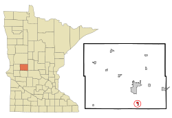
Douglas County Minnesota Incorporated and Unincorporated areas Forada Highlighted.svg
Location of Forada, Minnesota
Coordinates: 45°47′19″N95°21′26″W / 45.78861°N 95.35722°W / 45.78861; -95.35722
CountryUnited States
State Minnesota
County Douglas
Area
[1]
  Total0.54 sq mi (1.41 km2)
  Land0.54 sq mi (1.39 km2)
  Water0.01 sq mi (0.02 km2)
Elevation
[2]
1,417 ft (432 m)
Population
 (2020)
  Total170
  Density316.57/sq mi (122.18/km2)
Time zone UTC-6 (Central (CST))
  Summer (DST) UTC-5 (CDT)
ZIP code
56308 [3]
FIPS code 27-21608 [4]
GNIS feature ID2394784 [2]
Website foradadays.com

Forada is a city in Douglas County, Minnesota, United States. The population was 170 at the 2020 census. [5]

Contents

History

Forada was platted in 1903, and named for Ada Campbell, the founder's wife. [6] A post office was established at Forada in 1904, and remained in operation until it was discontinued in 1954. on May 30, 2022, an EF2 tornado struck the town severely damaging several homes and buisnesess. [7]

Geography

According to the United States Census Bureau, the city has a total area of 0.55 square miles (1.42 km2), of which 0.54 square miles (1.40 km2) is land and 0.01 square miles (0.03 km2) is water. [8]

Minnesota State Highway 29 and County Highway 4 are two of the main routes in the community.

Demographics

Historical population
CensusPop.Note
1910 66
1920 9239.4%
1930 91−1.1%
1940 965.5%
1950 89−7.3%
1960 9810.1%
1970 15861.2%
1980 19120.9%
1990 171−10.5%
2000 19715.2%
2010 185−6.1%
2020 170−8.1%
U.S. Decennial Census [9]
2020 Census [5]

2010 census

As of the census [10] of 2010, there were 185 people, 82 households, and 58 families residing in the city. The population density was 342.6 inhabitants per square mile (132.3/km2). There were 125 housing units at an average density of 231.5 per square mile (89.4/km2). The racial makeup of the city was 97.8% White, 0.5% Asian, and 1.6% from two or more races. Hispanic or Latino of any race were 1.1% of the population.

There were 82 households, of which 23.2% had children under the age of 18 living with them, 56.1% were married couples living together, 12.2% had a female householder with no husband present, 2.4% had a male householder with no wife present, and 29.3% were non-families. 19.5% of all households were made up of individuals, and 6.1% had someone living alone who was 65 years of age or older. The average household size was 2.26 and the average family size was 2.52.

The median age in the city was 50.8 years. 17.3% of residents were under the age of 18; 4.3% were between the ages of 18 and 24; 21.1% were from 25 to 44; 31.4% were from 45 to 64; and 25.9% were 65 years of age or older. The gender makeup of the city was 49.2% male and 50.8% female.

2000 census

As of the census [4] of 2000, there were 197 people, 82 households, and 63 families residing in the city. The population density was 370.5 inhabitants per square mile (143.1/km2). There were 118 housing units at an average density of 221.9 per square mile (85.7/km2). The racial makeup of the city was 100.00% White.

There were 82 households, out of which 25.6% had children under the age of 18 living with them, 63.4% were married couples living together, 11.0% had a female householder with no husband present, and 22.0% were non-families. 14.6% of all households were made up of individuals, and 7.3% had someone living alone who was 65 years of age or older. The average household size was 2.40 and the average family size was 2.63.

In the city, the population was spread out, with 20.8% under the age of 18, 6.6% from 18 to 24, 29.4% from 25 to 44, 27.4% from 45 to 64, and 15.7% who were 65 years of age or older. The median age was 43 years. For every 100 females, there were 99.0 males. For every 100 females age 18 and over, there were 92.6 males.

The median income for a household in the city was $33,393, and the median income for a family was $34,286. Males had a median income of $23,750 versus $20,625 for females. The per capita income for the city was $16,736. About 7.4% of families and 5.4% of the population were below the poverty line, including 12.5% of those under the age of eighteen and none of those 65 or over.
Related Research Articles

<span class="mw-page-title-main">Gilman, Minnesota</span> City in Minnesota, United States

Gilman is a city in Benton County, Minnesota, United States. The population was 224 at the 2010 census. It is part of the St. Cloud Metropolitan Statistical Area.

<span class="mw-page-title-main">Chickamaw Beach, Minnesota</span> City in Minnesota, United States

Chickamaw Beach is a city in Cass County, Minnesota, United States. The population was 114 at the 2010 census. It is part of the Brainerd Micropolitan Statistical Area.

<span class="mw-page-title-main">Shafer, Minnesota</span> City in Minnesota, United States

Shafer is a city in Chisago County, Minnesota, United States. The population was 1,045 at the 2010 census. The city was named for Jacob Shafer, a pioneer settler.

<span class="mw-page-title-main">Ironton, Minnesota</span> City in Minnesota, United States

Ironton is a city in Crow Wing County, Minnesota, United States. The population was 572 at the 2010 census. It is part of the Brainerd Micropolitan Statistical Area.

<span class="mw-page-title-main">Trommald, Minnesota</span> City in Minnesota, United States

Trommald is a city in Crow Wing County, Minnesota, United States. The population was 98 at the 2010 census. It is part of the Brainerd Micropolitan Statistical Area.

<span class="mw-page-title-main">Carlos, Minnesota</span> City in Minnesota, United States

Carlos is a city in Douglas County, Minnesota, United States. The population was 497 at the 2020 census.

<span class="mw-page-title-main">Garfield, Minnesota</span> City in Minnesota, United States

Garfield is a city in Douglas County, Minnesota, United States. The population was 349 at the 2020 census.

<span class="mw-page-title-main">Walters, Minnesota</span> City in Minnesota, United States

Walters is a city in Faribault County, Minnesota, United States. The population was 73 at the 2010 census.

<span class="mw-page-title-main">Nashwauk, Minnesota</span> City in Minnesota, United States

Nashwauk is a city in Itasca County, Minnesota, United States. The population was 983 at the 2010 census.

<span class="mw-page-title-main">Squaw Lake, Minnesota</span> City in Minnesota, United States

Squaw Lake is a city in Itasca County, Minnesota, United States. The population was 107 at the 2010 census.

<span class="mw-page-title-main">Warba, Minnesota</span> City in Minnesota, United States

Warba is a city in Itasca County, Minnesota, United States. The population was 181 at the 2010 census.

<span class="mw-page-title-main">New London, Minnesota</span> City in Minnesota, United States

New London is a city in Kandiyohi County, Minnesota, United States along the Middle Fork of the Crow River. The population was 1,251 at the 2010 census. Sibley State Park is nearby. It was named after New London, Wisconsin, by Louis Larson because of the similarity he saw with his previous home there. It was incorporated on April 8, 1889. The city was the temporary county seat of Kandiyohi County from 1867 to 1870.

<span class="mw-page-title-main">Racine, Minnesota</span> City in Minnesota, United States

Racine is a city in Racine Township, Mower County, Minnesota, United States. The population was 442 at the 2010 census.

<span class="mw-page-title-main">Henriette, Minnesota</span> City in Minnesota, United States

Henriette, is a city in Pine County, Minnesota, United States. The population was 71 at the 2010 census.

<span class="mw-page-title-main">Kerrick, Minnesota</span> City in Minnesota, United States

Kerrick is a city in Pine County, Minnesota, United States. The population was 65 at the 2010 census.

<span class="mw-page-title-main">Sturgeon Lake, Minnesota</span> City in Minnesota, United States

Sturgeon Lake is a city in Pine County, Minnesota, United States. The population was 439 at the 2010 census.

<span class="mw-page-title-main">Greenwald, Minnesota</span> City in Minnesota, United States

Greenwald is a city in Stearns County, Minnesota, United States. The population was 222 at the 2010 census. It is part of the St. Cloud Metropolitan Statistical Area.

<span class="mw-page-title-main">Fifty Lakes, Minnesota</span> City in Minnesota, United States

Fifty Lakes is a city in Crow Wing County, Minnesota, United States. The population was 387 at the 2010 census. It is part of the Brainerd Micropolitan Statistical Area.

<span class="mw-page-title-main">St. Anthony, Stearns County, Minnesota</span> City in Minnesota, United States

St. Anthony is a city in Stearns County, Minnesota, United States. The population was 86 at the 2010 census. It is part of the St. Cloud Metropolitan Statistical Area. Main routes include Minnesota State Highway 238, Stearns County Road 153, and Trobec Street.

<span class="mw-page-title-main">Dennison, Minnesota</span> City in Minnesota, United States

Dennison is a city in Goodhue and Rice counties in the U.S. state of Minnesota. The population was 212 at the 2010 census. Most of Dennison is in Goodhue County, with only a small part that extends into Rice County.

References

  1. "2020 U.S. Gazetteer Files". United States Census Bureau. Retrieved July 24, 2022.
  2. 1 2 U.S. Geological Survey Geographic Names Information System: Forada, Minnesota
  3. "Zipdatamaps" . Retrieved January 13, 2020.
  4. 1 2 "American FactFinder". United States Census Bureau. Archived from the original on February 12, 2020. Retrieved January 31, 2008.
  5. 1 2 "2020 Census Redistricting Data (Public Law 94-171) Summary File". American FactFinder. United States Census Bureau . Retrieved May 10, 2022.
  6. Upham, Warren (1920). Minnesota Geographic Names: Their Origin and Historic Significance. Minnesota Historical Society. p.  176.
  7. "Douglas County". Jim Forte Postal History. Retrieved May 20, 2015.
  8. "US Gazetteer files 2010". United States Census Bureau. Archived from the original on January 25, 2012. Retrieved November 13, 2012.
  9. "Census of Population and Housing". Census.gov. Archived from the original on April 26, 2015. Retrieved June 4, 2015.
  10. "American FactFinder". United States Census Bureau. Archived from the original on February 12, 2020. Retrieved November 13, 2012.