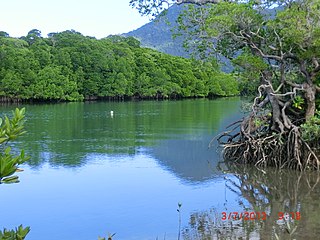
Daintree is a rural town and locality in the Shire of Douglas, Queensland, Australia. In the 2021 census, the locality of Daintree had a population of 93 people.

Cape Tribulation is a headland and coastal locality in the Shire of Douglas in northern Queensland, Australia. In the 2021 census, Cape Tribulation had a population of 123 people.

Mossman is a rural town and locality in the Shire of Douglas, Queensland, Australia. It is the administrative centre for the Douglas Shire Council In the 2021 census, the locality of Mossman had a population of 1,935 people.
Ringtail Creek is a rural locality in the Shire of Noosa, Queensland, Australia. In the 2021 census, Ringtail Creek had a population of 203 people.

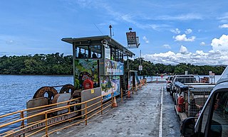
The Daintree River Ferry is a cable ferry across the Daintree River between the localities of Forest Creek and Lower Daintree in the Shire of Douglas, Queensland, Australia. The ferry is situated some 50 kilometres (31 mi) north of Port Douglas, and gives access to the northern section of the Daintree National Park and to Cape Tribulation. The ferry provides the only sealed road access to this area.

Bloomfield is a rural town in the Shire of Cook and a coastal locality which is split between the Shire of Cook and the Shire of Douglas in Queensland, Australia. The neighbourhood of Ayton is within the locality. In the 2021 census, the locality of Bloomfield had a population of 228 people.

Miallo is a rural locality in the Shire of Douglas, Queensland, Australia. In the 2021 census, Miallo had a population of 406 people.

Bemerside is a rural locality in the Shire of Hinchinbrook, Queensland, Australia. In the 2021 census, Bemerside had a population of 259 people.

Mowbray is a coastal locality in the Shire of Douglas, Queensland, Australia. In the 2021 census, Mowbray had a population of 362 people.

Cow Bay is a coastal locality in the Shire of Douglas, Queensland, Australia. In the 2021 census, Cow Bay had a population of 220 people.

Whyanbeel is a rural locality in the Shire of Douglas, Queensland, Australia. In the 2021 census, Whyanbeel had a population of 172 people.

Rocky Point is a coastal rural locality in the Shire of Douglas, Queensland, Australia. In the 2021 census, Rocky Point had a population of 145 people.

Barron Gorge is a rural locality in the Cairns Region, Queensland, Australia. In the 2021 census, Barron Gorge had "no people or a very low population".
Groper Creek is a coastal town and rural locality in the Shire of Burdekin, Queensland, Australia. In the 2021 census, the locality of Groper Creek had a population of 66 people.

Newell is a coastal town and rural locality in the Shire of Douglas, Queensland, Australia. It is a sugarcane growing district.
Cooya Beach is a coastal town and locality in the Shire of Douglas, Queensland, Australia. In the 2021 census, the locality of Cooya Beach had a population of 523 people.

Diwan is a coastal locality in the Shire of Douglas, Queensland, Australia. In the 2021 census, Diwan had a population of 169 people.

Lower Daintree is a coastal rural locality in the Shire of Douglas, Queensland, Australia. In the 2021 census, Lower Daintree had a population of 83 people.

Kimberley is a coastal locality in the Shire of Douglas, Queensland, Australia. In the 2021 census, Kimberley had a population of 28 people.

Low Isles is an offshore locality in the Shire of Douglas, Queensland, Australia. Located in the Coral Sea, the islands are due east of Rocky Point and approximately 14.5 kilometres (9.0 mi) north-east of Port Douglas on the Queensland mainland coast. In the 2021 census, Low Isles had "no people or a very low population".


