
Hill County is a county located in the U.S. state of Montana. As of the 2020 census, the population was 16,309. Its county seat is Havre. It lies along the United States border with Canada, abutting Alberta and Saskatchewan.

Havre is the county seat and largest city in Hill County, Montana, United States. Havre is nicknamed the crown jewel of the Hi-Line. It is said to be named after the city of Le Havre in France. As of the 2020 census the population was 9,362.
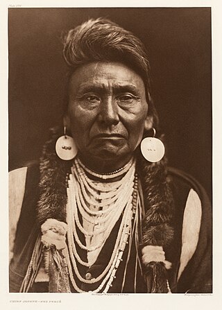
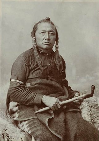
Hin-mah-too-yah-lat-kekt, popularly known as Chief Joseph, Young Joseph, or Joseph the Younger, was a leader of the wal-lam-wat-kain (Wallowa) band of Nez Perce, a Native American tribe of the interior Pacific Northwest region of the United States, in the latter half of the 19th century. He succeeded his father Tuekakas in the early 1870s.
The Chippewa Cree Tribe is a Native American tribe on the Rocky Boy's Reservation in Montana who are descendants of Cree who migrated south from Canada and Chippewa (Ojibwe) who moved west from the Turtle Mountains in North Dakota in the late 19th century. The two different peoples spoke related but distinct Algonquian languages. They are federally recognized as the Chippewa Cree Indians of the Rocky Boy's Reservation.

The Nez Perce War was an armed conflict in 1877 in the Western United States that pitted several bands of the Nez Perce tribe of Native Americans and their allies, a small band of the Palouse tribe led by Red Echo (Hahtalekin) and Bald Head, against the United States Army. Fought between June and October, the conflict stemmed from the refusal of several bands of the Nez Perce, dubbed "non-treaty Indians," to give up their ancestral lands in the Pacific Northwest and move to an Indian reservation in Idaho Territory. This forced removal was in violation of the 1855 Treaty of Walla Walla, which granted the tribe 7.5 million acres of their ancestral lands and the right to hunt and fish on lands ceded to the U.S. government.

Rocky Boy's Indian Reservation is one of seven Native American reservations in the U.S. state of Montana. Established by an act of Congress on September 7, 1916, it was named after Ahsiniiwin, the chief of the Chippewa band, who had died a few months earlier. It was established for landless Chippewa (Ojibwe) Indians in the American West, but within a short period of time many Cree (nēhiyaw) and Métis were also settled there. Today the Cree outnumber the Chippewa on the reservation. The Bureau of Indian Affairs (BIA) recognizes it as the Chippewa Cree Reservation.
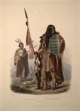
The Assiniboine or Assiniboin people, also known as the Hohe and known by the endonym Nakota, are a First Nations/Native American people originally from the Northern Great Plains of North America.

The Battle of Bear Paw was the final engagement of the Nez Perce War of 1877. Following a 1,200-mile (1,900 km) running fight from north central Idaho Territory over the previous four months, the U.S. Army managed to corner most of the Nez Perce led by Chief Joseph in early October 1877 in northern Montana Territory, just 42 miles (68 km) south of the border with Canada, where the Nez Perce intended to seek refuge from persecution by the U.S. government.
This is a broad outline of the history of Montana in the United States.

The Bears Paw Mountains are an insular-montane island range in the Central Montana Alkalic Province in north-central Montana, United States, located approximately 10 miles south of Havre, Montana. Baldy Mountain, which rises 6,916 feet (2,108 m) above sea level, is the highest peak in the range. The Bears Paw Mountains extend in a 45-mile arc between the Missouri River and Rocky Boy Indian Reservation south of Havre.
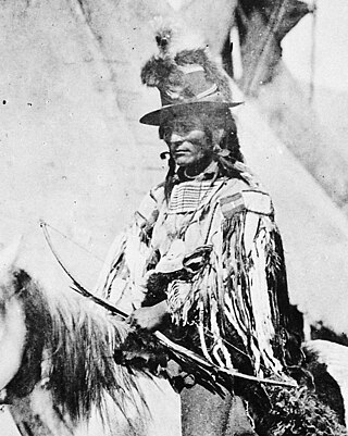
Looking Glass was a principal Nez Perce architect of many of the military strategies employed by the Nez Perce during the Nez Perce War of 1877. He, along with Chief Joseph, directed the 1877 retreat from eastern Oregon into Montana and onward toward the Canada–US border during the Nez Perce War. He led the Alpowai band of the Nez Perce, which included the communities of Asotin, Alpowa, and Sapachesap along the Clearwater River in Idaho. He inherited his name from his father, the prominent Nez Percé chief Apash Wyakaikt or Ippakness Wayhayken and was therefore called by the whites Looking Glass.

Bear Paw Ski Bowl is a small ski area which draws visitors primarily from Havre, Montana and the nearby Rocky Boys Indian Reservation located on the Chippewa Cree Recreation Area in north central Montana, along the Hi-Line. The Chippewa Cree tribe owns Bear Paw, and it is managed by a volunteer non-profit organization called the Snow Dance Ski Association, along with the Eagle Creek Ski Patrol. The ski area has existed since 1959 and has been developed over the years gradually by the association and the tribe. It was temporarily closed from February 1993 to March 1994, when a crew using faulty equipment tried to make some adjustments and repairs on the gantry, and the chairlift.
The Battle of Canyon Creek was a military engagement in Montana Territory between the Nez Perce Indians and the United States Army's 7th Cavalry. The battle was part of the larger Indian Wars of the latter 19th century and the immediate Nez Perce War. It took place on September 13, 1877, west of present-day Billings in Yellowstone County, in the canyons and benches around Canyon Creek.

Thomas Little Shell III was a chief of a band of the Ojibwa (Chippewa) tribe in the second half of the nineteenth century, when the Anishinaabeg had a vast territory ranging from southwestern Canada into the northern tier of the United States, from the Dakotas and into Montana.
Fort Shaw was a United States Army fort located on the Sun River 24 miles west of Great Falls, Montana, in the United States. It was founded on June 30, 1867, and abandoned by the Army in July 1891. It later served as a school for Native American children from 1892 to 1910. Portions of the fort survive today as a small museum. The fort lent its name to the community of Fort Shaw, Montana, which grew up around it.
Asiniiwin, translated Rocky Boy or Stone Child, was an important Ojibwe leader who was chief of a band in Montana in the late 19th century and early 20th century. His advocacy for his people helped gain the establishment of what is called Rocky Boy's Indian Reservation in his honor. Formed from part of Fort Assiniboine, which was closed, it is located in Hill and Chouteau counties in north central Montana.
Little Bear was a Cree leader who lived in the District of Alberta, Idaho Territory, Montana Territory, and District of Saskatchewan regions of Canada and the United States, in the 19th and early 20th centuries. He is known for his participation in the 1885 North-West Rebellion, which was fought in Alberta and Saskatchewan.
The Iron Confederacy or Iron Confederation was a political and military alliance of Plains Indians of what is now Western Canada and the northern United States. This confederacy included various individual bands that formed political, hunting and military alliances in defense against common enemies. The ethnic groups that made up the Confederacy were the branches of the Cree that moved onto the Great Plains around 1740, the Saulteaux, the Nakoda or Stoney people also called Pwat or Assiniboine, and the Métis and Haudenosaunee. The Confederacy rose to predominance on the northern Plains during the height of the North American fur trade when they operated as middlemen controlling the flow of European goods, particularly guns and ammunition, to other Indigenous nations, and the flow of furs to the Hudson's Bay Company (HBC) and North West Company (NWC) trading posts. Its peoples later also played a major part in the bison (buffalo) hunt, and the pemmican trade. The decline of the fur trade and the collapse of the bison herds sapped the power of the Confederacy after the 1860s, and it could no longer act as a barrier to U.S. and Canadian expansion.
This is a timeline of pre-statehood Montana history comprising substantial events in the history of the area that would become the State of Montana prior to November 8, 1889. This area existed as Montana Territory from May 28, 1864, until November 8, 1889, when it was admitted to the Union as the State of Montana.

A number of different Native Americans living in present-day Montana entered into treaties with the United States during the 19th Century. Most of the treaties included an article that established the territory of the tribe entering into it. More and more of this Indian land turned into public or U.S. territory with the signing of new treaties..


