Fort Washington (Cincinnati, Ohio)

Last updated

Fort Washington
Part of the Northwest Territory of the United States
Cincinnati, Ohio
Fort Washington-Cincinnati.png
Coordinates 39°5′58.24″N84°30′26.59″W / 39.0995111°N 84.5073861°W / 39.0995111; -84.5073861 Coordinates: 39°5′58.24″N84°30′26.59″W / 39.0995111°N 84.5073861°W / 39.0995111; -84.5073861
TypeArmy Fortress
Site history
Built1789
Demolished1806
Battles/wars Northwest Indian War
Garrison information
Past
commanders
Gen. Arthur St. Clair, Gen. Josiah Harmar, Gen. "Mad" Anthony Wayne, Gen. James Wilkinson
Occupants United States Army
Fort Washington Fort Washington.jpg
Fort Washington

Fort Washington was a fortified stockade with blockhouses built by order of Gen. Josiah Harmar starting in summer 1789 in what is now downtown Cincinnati, Ohio near the Ohio River. The physical location of the fort was facing the mouth of the Licking River, above present day Fort Washington Way. The fort was named in honor of President George Washington. The Fort was the major staging place and conduit for settlers, troups and supplies during the conquest and settlement of the Northwest Territory.

Josiah Harmar United States general

Josiah Harmar was an officer in the United States Army during the American Revolutionary War and the Northwest Indian War. He was the senior officer in the Army for six years and seven months.

Cincinnati City in Ohio

Cincinnati is a major city in the U.S. state of Ohio, and is the government seat of Hamilton County. Settled in 1788, the city is located at the northern side of the confluence of the Licking and Ohio rivers, the latter of which marks the state line with Kentucky. The city drives the Cincinnati–Middletown–Wilmington combined statistical area, which had a population of 2,172,191 in the 2010 census making it Ohio's largest metropolitan area. With a population of 301,301, Cincinnati is the third-largest city in Ohio and 65th in the United States. Its metropolitan area is the fastest growing economic power in the Midwestern United States based on increase of economic output and it is the 28th-largest metropolitan statistical area in the U.S. Cincinnati is also within a day's drive of 49.70% of the United States populace.

Licking River (Kentucky) tributary of the Ohio River in northeastern Kentucky in the United States

The Licking River is a partly navigable, 303-mile-long (488 km) tributary of the Ohio River in northeastern Kentucky in the United States. The river and its tributaries drain much of the region of northeastern Kentucky between the watersheds of the Kentucky River to the west and the Big Sandy River to the east. The North Fork Licking River, in Pendleton County, Kentucky is one of its tributaries.

Contents

In 1803, the fort was moved to Newport, KY across the river and became the Newport Barracks. In 1806, the site of the abandoned fort was divided into lots and sold.

Newport Barracks hospital

Newport Barracks was a military barracks on the Ohio River, across from Cincinnati, Ohio in Newport, Kentucky. It was operational from 1803 until 1894.

Background

When the continental congress issued a patent for sale of 248,250 acres to Judge John Cleves Symmes, known as Symmes Purchase in 1788, it reserved 15 acres to the federal government for the fort. [2] In 1789, Fort Washington was built to protect early settlements located in the Miami River valley.

John Cleves Symmes American politician

John Cleves Symmes was a delegate to the Continental Congress from New Jersey, and later a pioneer in the Northwest Territory. He was also the father-in-law of President William Henry Harrison.

Symmes Purchase

The Symmes Purchase, also known as the Miami Purchase, was an area of land totaling roughly 311,682 acres (487.003 sq mi) in what is now Hamilton, Butler, and Warren counties of southwestern Ohio, purchased by Judge John Cleves Symmes of New Jersey in 1788 from the Continental Congress.

Fort Washington in Cincinnati Fort Washington Cincinnati map.png
Fort Washington in Cincinnati

Gen. Arthur St. Clair was appointed governor of the Northwest Territory by vote of Congress on October 5, 1787. When Governor St. Clair arrived at Losantiville [Cincinnati] the settlement consisted of two small hewed log houses and several cabins. Maj. John Doughty, under orders from Gen. Josiah Harmar, was engaged with a small military force in finishing the construction of Fort Washington. The population of the rude village, exclusive of the military, probably did not exceed one hundred and fifty. [3] Three days after Gen. Harmar took up his quarters at Fort Washington, on January 1, 1790, Governor St. Clair was received with due ceremony by the troops and citizens of Losantiville.

Arthur St. Clair American soldier and politician

Arthur St. Clair was a Scottish-American soldier and politician. Born in Thurso, Scotland, he served in the British Army during the French and Indian War before settling in Pennsylvania, where he held local office. During the American Revolutionary War, he rose to the rank of major general in the Continental Army, but lost his command after a controversial retreat from Fort Ticonderoga.

Northwest Territory United States territory (1787-1803)

The Northwest Territory in the United States was formed after the American Revolutionary War, and was known formally as the Territory Northwest of the River Ohio. It was the initial post-colonial Territory of the United States and encompassed most of pre-war British colonial territory west of the Appalachian mountains north of the Ohio River. It included all the land west of Pennsylvania, northwest of the Ohio River and east of the Mississippi River below the Great Lakes. It spanned all or large parts of six eventual U.S. States. It was created as a Territory by the Northwest Ordinance July 13, 1787, reduced to Ohio, eastern Michigan and a sliver of southeastern Indiana with the formation of Indiana Territory July 4, 1800, and ceased to exist March 1, 1803, when the southeastern portion of the territory was admitted to the Union as the state of Ohio, and the remainder attached to Indiana Territory.

John Doughty United States general

John Doughty was an American military officer who briefly served as the senior officer of the United States Army in 1784.

Fort Washington was distinguished by its large size: it was larger than a modern city block and designed to house up to 1500 men. Gen. Josiah Harmar described it as "one of the most solid substantial wooden fortresses. . .of any in the Western Territory." The stockade's walls were two stories high with blockhouses located at each corner. [4]

Indian campaigns

The fort was used as a staging point and to supply all the northern forts. It played a key supporting role in three Indian campaigns: Harmar's Campaign 1790, St. Clair's Campaign 1791, and Gen. "Mad" Anthony Wayne's campaign in 1793-94.

In 1790, Harmar used Fort Washington to launch an expedition against Native Americans in northwest Ohio, especially the Miami Indians, whose principal city was Kekionga (modern-day Fort Wayne, Indiana). On October 22, 1790, Gen. Harmar's army was ambushed and massacred by Indians led by Chief Little Turtle. The Indians of the Ohio Territory were in open revolt aided by the British. Indian raids came close to Cincinnati, despite the presence of the nearby Fort Washington.

Kekionga also known as Kiskakon or Pacan's Village, was the capital of the Miami tribe. It was located at the confluence of the Saint Joseph, Saint Marys and Maumee rivers on the western edge of the Great Black Swamp in present-day Indiana. Over their respective decades of influence from colonial times to after the American Revolution and Northwest Indian Wars, the French, British and Americans all established trading posts and forts at the large village, as it was located on an important portage connecting Lake Erie to the Wabash and Mississippi rivers. The European-American town of Fort Wayne, Indiana started as a settlement around the American Fort Wayne stockade after the War of 1812.

Fort Wayne, Indiana City in Indiana

Fort Wayne is a city in the U.S. state of Indiana and the seat of Allen County, United States. Located in northeastern Indiana, the city is 18 miles (29 km) west of the Ohio border and 50 miles (80 km) south of the Michigan border. With a population of 253,691 in the 2010 census, it is the second-most populous city in Indiana after Indianapolis, and the 75th-most populous city in the United States. It is the principal city of the Fort Wayne metropolitan area, consisting of Allen, Wells, and Whitley counties, a combined population of 419,453 as of 2011. Fort Wayne is the cultural and economic center of northeastern Indiana. The city is within a 300-mile radius of major population centers, including Chicago, Cincinnati, Cleveland, Columbus, Detroit, Indianapolis, Louisville, Lexington, and Milwaukee. In addition to the three core counties, the combined statistical area (CSA) includes Adams, DeKalb, Huntington, Noble, and Steuben counties, with an estimated population of 615,077.

Little Turtle Chief of the Miami people (c. 1747 – July 14, 1812)

Little Turtle,, was a Sagamore (chief) of the Miami people, who became one of the most famous Native American military leaders. Historian Wiley Sword calls him "perhaps the most capable Indian leader then in the Old Northwest," although he later signed several treaties ceding land, which caused him to lose his leader status during the battles which became a prelude to the War of 1812. In the 1790s, Mihšihkinaahkwa led a confederation of native warriors to several major victories against U.S. forces in the Northwest Indian Wars,sometimes called "Little Turtle's War", particularly St. Claires Defeat in 1791, wherein the confederation defeated General Arthur St. Clair, who lost 900 men in the most decisive loss by the U.S. Army against Native American forces.

In the summer of 1793, Major General Anthony Wayne moved his forces from the training center at Legionville, PA, down the Ohio River by barge to a camp outside Fort Washington that was called Hobson's Choice. In the fall, Wayne departed fort Washington and moved his army northward, past Fort Jefferson to build Fort Greene Ville.

Decline and sale

In 1803 Fort Washington was replaced by the larger Newport Barracks. It was opened just across the Ohio River in Newport, Kentucky. James Taylor Jr. an influential resident of Newport, Kentucky, had lobbied his cousin James Madison to place the post in Newport.

On February 28, 1806, Congress directed the Secretary of the Treasury to cause the site of the abandoned fort to be surveyed and laid off into lots, streets and avenues conforming to the plan of the city, and to sell the lots to the highest bidders at a sale at the Cincinnati Land Office. [5] [6] The survey, certified July 8, 1807, shows the fort's boundaries to be Fourth Street to the north, Ludlow Street to the east, the Ohio River to the south, and Broadway to the west. [7]

Rediscovery

In October 1952, excavators discovered the remnants of Fort Washington's gunpowder magazine under the northeast corner of Broadway and Third streets, at the site at which Western & Southern Life Insurance Company's parking garage was to be constructed. Researchers with the Historical and Philosophical Society of Ohio first visited the site on October 13, 1952. [8] [9]

The fort's name is retained in Fort Washington Way, a section of Interstate 71 and U.S. Route 50 that runs through downtown Cincinnati and passes just in front of the former fort. The highway was given this name in 1958 upon a suggestion from the Cincinnati Times-Star editorial board and with the support of the state's Anthony Wayne Parkway Board, the Cincinnati Enquirer editorial board, and Mrs. William T. Buckner, whose great-grandfather William Henry Harrison once served at the fort. [10] [11] [12]

The location is marked by a plaque at the Guilford School building, at 421 E 4th St, Cincinnati, which now occupies the site.

Notes

  1. Lossing, Benson (1868). The Pictorial Field-Book of the War of 1812. Harper & Brothers, Publishers. p. 41.
  2. Knepper 2002  : 32
  3. History Of Cincinnati And Hamilton County, Ohio
  4. Fort Washington – Ohio History Central – A product of the Ohio Historical Society
  5. Peters, William E. (1918). Ohio Lands and Their Subdivision. W.E. Peters. p. 282.
  6. 2  Stat.   352 – Text of Act of February 28, 1806 Library of Congress
  7. Knepper 2002  : 54
  8. Knopf, Richard C.; Baby, Raymond S.; Smith, Dwight L. (January 1953). "The Re-Discovery of Fort Washington" (PDF). Bulletin of the Historical and Philosophical Society of Ohio. Cincinnati, Ohio: Historical and Philosophical Society of Ohio. 11 (1): 3–12. Retrieved October 25, 2015.
  9. Baby, Raymond S.; Knopf, Richard C. "Additional Structural Features of the Fort Washington Powder Magazine" (PDF). Bulletin of the Historical and Philosophical Society of Ohio. 11 (4): 320–325. Retrieved October 25, 2015.
  10. "Three Roads, Three Heroes". Editorial. The Cincinnati Enquirer . Gannett Company. February 21, 1958. p. 4. Retrieved October 25, 2015 via Newspapers.com. (Subscription required (help)).
  11. Kirkpatrick, Dick (February 15, 1958). "Board Urges Development Of Waterfront To Preserve Area's Historical Resources". The Cincinnati Enquirer. p. 1. Retrieved October 25, 2015 via Newspapers.com. (Subscription required (help)).
  12. Sands, Gilbert (February 25, 1959). "Fort Washington Freeway Favored Name For Distributor". The Cincinnati Enquirer. p. 10 via Newspapers.com. (Subscription required (help)).

Related Research Articles

Northwest Indian War 1785-1795 war between a confederation of Native Americans and the United States

The Northwest Indian War (1785–1795), also known as the Ohio War, Little Turtle's War, and by other names, was a war between the United States and a confederation of numerous Native American tribes, with support from the British, for control of the Northwest Territory. It followed centuries of conflict over this territory, first among Native American tribes, and then with the added shifting alliances among the tribes and the European powers of France and Great Britain, and their colonials.

William Darke General in the US military

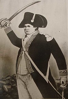
William Darke was an American soldier. In 1740, he moved from Philadelphia, Pennsylvania to Virginia. He was in Braddock's army in the defeat in 1755, and was made a captain at the beginning of the American Revolutionary War. He was made prisoner at the Battle of Germantown, and was commanding colonel of the Hampshire and Berkeley regiments at the capture of Cornwallis. Darke was often a member of the Virginia legislature, and, in the convention of 1788, voted for the Federal Constitution. Lieutenant-colonel of the regiment of "Levies" in 1791, he commanded the left wing of the St. Clair's army, at its defeat by the Miami Indians, November 4, 1791. He made two unsuccessful charges with the bayonet in this fight, in the second of which his younger son, Captain Joseph Darke, was killed, and he himself was wounded and narrowly escaped death. He wrote a letter to President George Washington describing the battle. Afterwards, Darke was a major-general of the Virginia militia. He died on November 26, 1801.

Fort Recovery United States Army fort in Fort Recovery, Ohio, now a museum

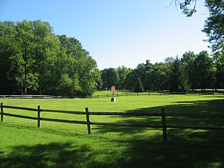
Fort Recovery was a United States Army fort ordered built by General "Mad" Anthony Wayne during what is now termed the Northwest Indian War. Constructed from late 1793 and completed in March 1794, the fort was built along the Wabash River, within two miles of what became the Ohio state border with Indiana. A detachment of Wayne's Legion of the United States held off an attack from combined Indian forces on June 30, 1794. The fort was used as a reference in drawing treaty lines for the 1795 Treaty of Greenville, and for later settlement. The fort was abandoned in 1796.

Legion of the United States

The Legion of the United States was a reorganization and extension of the Continental Army from 1792 to 1796 under the command of Major General Anthony Wayne composed of professionally trained soldiers, rather than state militias. The Legion was composed of four sub-legions each with its own infantry, cavalry, riflemen and artillery.

Charles Scott (governor) governor of Kentucky from 1808 to 1812

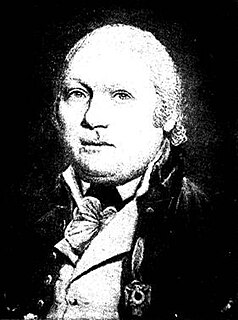
Charles Scott was an 18th-century American soldier who was elected the fourth Governor of Kentucky in 1808. Orphaned in his teens, Scott enlisted in the Virginia Regiment in October 1755 and served as a scout and escort during the French and Indian War. He quickly rose through the ranks to become a captain. After the war, he married and engaged in agricultural pursuits on land left to him by his father, but he returned to active military service in 1775 as the American Revolution began to grow in intensity. In August 1776, he was promoted to colonel and given command of the 5th Virginia Regiment. The 5th Virginia joined George Washington in New Jersey later that year, serving with him for the duration of the Philadelphia campaign. Scott commanded Washington's light infantry, and by late 1778 was also serving as his chief of intelligence. Furloughed at the end of the Philadelphia campaign, Scott returned to active service in March 1779 and was ordered to South Carolina to assist General Benjamin Lincoln in the southern theater. He arrived in Charleston, South Carolina, just as Henry Clinton had begun his siege of the city. Scott was taken as a prisoner of war when Charleston surrendered. Paroled in March 1781 and exchanged for Lord Rawdon in July 1782, Scott managed to complete a few recruiting assignments before the war ended.

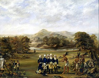
The Treaty of Fort Harmar was an agreement between the United States government and numerous Native American tribes with claims to the Northwest Territory. It was signed at Fort Harmar, near present-day Marietta, Ohio, on January 9, 1789. Representatives of the Iroquois Six Nations and other groups, including the Wyandot, Delaware, Ottawa, Chippewa, Potawatomi and Sauk met with Arthur St. Clair, the governor of the Northwest Territory, and other American leaders such as Josiah Harmar and Richard Butler.

History of Cincinnati history of the city in Ohio, United States

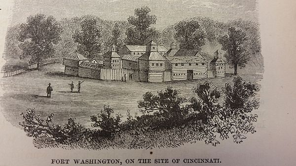
Cincinnati was founded in late December 1788 by Mathias Denman, Colonel Robert Patterson and Israel Ludlow. The original surveyor, John Filson, named it "Losantiville", from four terms, each of different language, before his death in October 1788. It means "The city opposite the mouth of the river"; "ville" is French for "city", "anti" is Greek for "opposite", "os" is Latin for "mouth", and "L" was all that was included of "Licking River".

James Fontaine was an officer who served in American Revolutionary War and the Northwest Indian War. The name is spelled several ways, including "Fountaine".

David Ziegler Mayor of Cincinnati

David Ziegler was a German immigrant to the United States who served in the U.S. military and became the first mayor of Cincinnati, Ohio.

Harmar Campaign

The Harmar Campaign was an attempt by the United States, in the fall of 1790, to subdue Native Americans in the Northwest Territory who were seeking to expel American settlers they saw as interlopers in their territory.

Fort Harmar

Fort Harmar was an early United States frontier military fort, built in pentagonal shape during 1785 at the confluence of the Ohio and Muskingum rivers, on the west side of the mouth of the Muskingum River. It was built under the orders of Colonel Josiah Harmar, then commander of the United States Army, and took his name. The fort was intended for the protection of Indians, i.e., to prevent pioneer squatters from settling in the land to the northwest of the Ohio River. "The position was judiciously chosen, as it commanded not only the mouth of the Muskingum, but swept the waters of the Ohio, from a curve in the river for a considerable distance both above and below the fort." It was the first frontier fort built in Ohio Country.

St. Clairs Defeat On November 4, 1791, part of the Northwest Indian War. It was a major American Indian victory and remains the greatest defeat of the United States Army by American Indians

St. Clair's Defeat also known as the Battle of the Wabash, the Battle of Wabash River or the Battle of a Thousand Slain, was a battle fought on November 4, 1791 in the Northwest Territory of the United States of America. The U.S. Army faced the Western Confederacy of Native Americans, as part of the Northwest Indian War. It was "the most decisive defeat in the history of the American military." It was the largest victory ever won by Native Americans.

Siege of Dunlaps Station

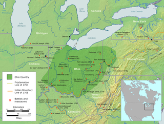
The Siege of Dunlap's Station was a battle that took place on January 10–11, 1791, during the Northwest Indian War between the Western Confederacy of American Indians and European-American settlers in what became the southwestern region of the U.S. state of Ohio. This was one of the Indians' few unsuccessful attacks during this period. It was shortly after the Harmar Campaign attacks and unprecedented defeat of U.S. Army forces. A few months after the siege, the Army's St. Clair's campaign famously failed.

Fort Steuben

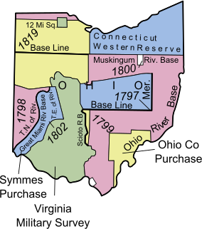
Fort Steuben was a fortification erected in Feb. 1787 on the Ohio River in eastern Ohio Country at the northern end of the Seven Ranges land tract to be surveyed. It was at the location of the modern city of Steubenville, Ohio. The fort was built by Major John Hamtramck and named for Friedrich Wilhelm von Steuben, a Prussian army officer who had served under General Washington. The original purpose was to provide protection from Indians for the first surveyors to venture into the Northwest Territory.

Fort St. Clair

Fort St. Clair was a fort built during the Northwest Indian War near the modern town of Eaton, Preble County, Ohio. The site of the fort was listed on the National Register of Historic Places in 1970.

References