Fresno, Ohio

Last updated

Fresno, Ohio
White Eyes Rural School.JPG
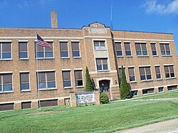
The former Fresno Elementary School
OHMap-doton-Fresno.png
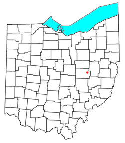
Location of Fresno, Ohio
Coordinates: 40°19′51″N81°44′19″W / 40.33083°N 81.73861°W / 40.33083; -81.73861
Country United States
State Ohio
County Coshocton
Townships White Eyes
Elevation
[1]
807 ft (246 m)
Population
 (2020) [2]
  Total140
Time zone UTC-5 (Eastern (EST))
  Summer (DST) UTC-4 (EDT)
ZIP
43824
Area code 740
GNIS feature ID2628893 [1]

Fresno is a census-designated place in eastern White Eyes Township, Coshocton County, Ohio, United States. [3] As of the 2020 census it had a population of 140. It has a post office with the ZIP code 43824. [4] It lies along State Route 93 between West Lafayette and Baltic.

Contents

History

Fresno was originally called Jacktown. [5] The residents apparently didn't like the name Jacktown, and the community was renamed Avondale by popular vote. [6] A post office was established under the name Avondale in 1875, and the name of the post office was changed to Fresno in 1905. [7]

Notable person

World-class runner Brian Olinger grew up in Fresno and attended Ridgewood High School. [8]

Related Research Articles

<span class="mw-page-title-main">Howard, Ohio</span> Census-designated place in Ohio, United States

Howard is a census-designated place (CDP) in southern Howard Township, Knox County, Ohio, United States. As of the 2020 census it had a population of 246. The United States Postal Service has assigned Howard the ZIP Code 43028. The community lies along U.S. Route 36.

<span class="mw-page-title-main">Bethlehem Township, Coshocton County, Ohio</span> Township in Ohio, United States

Bethlehem Township is one of the twenty-two townships of Coshocton County, Ohio, United States. As of the 2020 census the population was 1,054.

<span class="mw-page-title-main">Franklin Township, Coshocton County, Ohio</span> Township in Ohio, United States

Franklin Township is one of the twenty-two townships of Coshocton County, Ohio, United States. The 2020 census reported 1,165 people living in the township.

<span class="mw-page-title-main">Jackson Township, Coshocton County, Ohio</span> Township in Ohio, United States

Jackson Township is one of the twenty-two townships of Coshocton County, Ohio, United States. As of the 2020 census the population was 1,852.

<span class="mw-page-title-main">Keene Township, Coshocton County, Ohio</span> Township in Ohio, United States

Keene Township is one of the twenty-two townships of Coshocton County, Ohio, United States. As of the 2020 census the population was 1,623.

<span class="mw-page-title-main">White Eyes Township, Coshocton County, Ohio</span> Township in Ohio, United States

White Eyes Township is one of the twenty-two townships of Coshocton County, Ohio, United States. As of the 2020 census the population was 1,222.

<span class="mw-page-title-main">Derby, Ohio</span> CDP in Ohio, United States

Derby is a census-designated place in central Darby Township, Pickaway County, Ohio, United States. It is assigned the ZIP code 43117. The population was 355 at the 2020 census.

<span class="mw-page-title-main">Sulphur Springs, Ohio</span>

Sulphur Springs is a census-designated place (CDP) in eastern Liberty Township, Crawford County, Ohio, United States. As of the 2020 census it had a population of 197. It has a post office with the ZIP code 44881. It is located along State Route 98 northeast of the city of Bucyrus, the county seat of Crawford County.

Bladensburg is a census-designated place (CDP) on the border between Clay and Jackson townships, Knox County, Ohio, United States. As of the 2020 census the CDP had a population of 180. It has a post office with the ZIP code 43005. It lies along State Route 541 east of Martinsburg.

<span class="mw-page-title-main">Walhonding, Ohio</span> Unincorporated community in Ohio, U.S.

Walhonding is an unincorporated community in northern Newcastle Township, Coshocton County, Ohio, United States. It has a post office with the ZIP code 43843. It lies at the intersection of State Routes 206 and 715.

<span class="mw-page-title-main">Keene, Ohio</span> Unincorporated community in Ohio, U.S.

Keene is an unincorporated community in central Keene Township, Coshocton County, Ohio, United States. It has a post office with the ZIP code 43828.

<span class="mw-page-title-main">Bakersville, Ohio</span> Unincorporated community in Ohio, U.S.

Bakersville is an unincorporated community in northeastern Adams Township, Coshocton County, Ohio, United States. It has a post office with the ZIP code 43803. It lies along State Route 751 northeast of West Lafayette.

<span class="mw-page-title-main">Robertsville, Ohio</span> CDP in Ohio, United States

Robertsville is an unincorporated community and census-designated place in western Paris Township, Stark County, Ohio, United States. It has a post office with the ZIP code 44670. It lies along U.S. Route 30 between East Canton and Minerva and is in the Minerva Local School District. The community is part of the Canton–Massillon Metropolitan Statistical Area. The population was 293 at the 2020 census.

<span class="mw-page-title-main">Little Hocking, Ohio</span> Census-designated place in Ohio, US

Little Hocking is a census-designated place in southern Belpre Township, Washington County, Ohio, United States. It has a post office with the ZIP code 45742. The population of the CPD was 244 at the 2020 census.

New Bedford is an unincorporated community in Coshocton County, Ohio, United States.

Chili is an unincorporated community in Crawford Township, Coshocton County, Ohio, United States.

Bacon is an unincorporated community in Linton Township, Coshocton County, Ohio, United States.

Spring Mountain is an unincorporated community in Monroe Township, Coshocton County, Ohio, United States.

Canal Lewisville is an unincorporated community and census-designated place (CDP) in Coshocton County, Ohio, in the United States. As of the 2020 census it had a population of 417.

New Moscow is an unincorporated community in Virginia Township of Coshocton County, Ohio, United States.

References

  1. 1 2 U.S. Geological Survey Geographic Names Information System: Fresno, Ohio
  2. "Fresno CPD, Ohio - Census Bureau Profile". United States Census Bureau. Retrieved June 9, 2023.
  3. U.S. Geological Survey Geographic Names Information System: Fresno, Ohio
  4. Zip Code Lookup
  5. Bahmer, William J. (1909). Centennial History of Coshocton County, Ohio. S. J. Clarke Publishing Company. p.  75.
  6. Graham, Albert Adams (1881). History of Coshocton County, Ohio: Its Past and Present, 1740-1881. A. A. Graham. p.  621.
  7. "Coshocton County". Jim Forte Postal History. Archived from the original on December 8, 2015. Retrieved December 7, 2015.
  8. USATF.