Nellie, Ohio

Last updated

Nellie, Ohio
Nellie School Building.jpg
1938 Nellie School building
OHMap-doton-Nellie.png
Location of Nellie, Ohio
Map of Coshocton County Ohio Highlighting Nellie Village.png
Location of Nellie in Coshocton County
Coordinates: 40°20′19″N82°04′17″W / 40.33861°N 82.07139°W / 40.33861; -82.07139
Country United States
State Ohio
County Coshocton
Township Jefferson
Area
[1]
  Total0.68 sq mi (1.77 km2)
  Land0.68 sq mi (1.77 km2)
  Water0.00 sq mi (0.00 km2)
Elevation
[2]
824 ft (251 m)
Population
 (2020)
  Total122
  Density178.89/sq mi (69.04/km2)
Time zone UTC-5 (Eastern (EST))
  Summer (DST) UTC-4 (EDT)
FIPS code 39-53816 [3]
GNIS feature ID2399442 [2]

Nellie is a village in Coshocton County, Ohio, United States, along the Walhonding River. The population was 122 at the 2020 census.

Contents

The 1930s-era Mohawk Dam, a dry dam built for flood control, is just to the north and west of the village.

Geography

According to the United States Census Bureau, the village has a total area of 0.71 square miles (1.84 km2), all land. [4]

Demographics

Historical population
CensusPop.Note
1910 133
1920 1448.3%
1930 117−18.7%
1940 1213.4%
1950 16536.4%
1960 145−12.1%
1970 140−3.4%
1980 1507.1%
1990 130−13.3%
2000 1343.1%
2010 131−2.2%
2020 122−6.9%
U.S. Decennial Census [5]

2010 census

As of the census [6] of 2010, there were 131 people, 49 households, and 34 families living in the village. The population density was 184.5 inhabitants per square mile (71.2/km2). There were 56 housing units at an average density of 78.9 per square mile (30.5/km2). The racial makeup of the village was 98.5% White, 0.8% from other races, and 0.8% from two or more races.

There were 49 households, of which 34.7% had children under the age of 18 living with them, 53.1% were married couples living together, 8.2% had a female householder with no husband present, 8.2% had a male householder with no wife present, and 30.6% were non-families. 28.6% of all households were made up of individuals, and 12.3% had someone living alone who was 65 years of age or older. The average household size was 2.67 and the average family size was 3.15.

The median age in the village was 37.5 years. 28.2% of residents were under the age of 18; 5.4% were between the ages of 18 and 24; 29% were from 25 to 44; 22.9% were from 45 to 64; and 14.5% were 65 years of age or older. The gender makeup of the village was 52.7% male and 47.3% female.

2000 census

As of the census [3] of 2000, there were 134 people, 53 households, and 40 families living in the village. The population density was 188.6 inhabitants per square mile (72.8/km2). There were 104 housing units at an average density of 146.4 per square mile (56.5/km2). The racial makeup of the village was 96.27% White, 0.75% African American, and 2.99% from two or more races.

There were 53 households, out of which 30.2% had children under the age of 18 living with them, 64.2% were married couples living together, 9.4% had a female householder with no husband present, and 24.5% were non-families. 20.8% of all households were made up of individuals, and 11.3% had someone living alone who was 65 years of age or older. The average household size was 2.53 and the average family size was 2.95.

In the village, the population was spread out, with 24.6% under the age of 18, 11.9% from 18 to 24, 23.1% from 25 to 44, 26.9% from 45 to 64, and 13.4% who were 65 years of age or older. The median age was 38 years. For every 100 females there were 86.1 males. For every 100 females age 18 and over, there were 94.2 males.

The median income for a household in the village was $38,750, and the median income for a family was $40,417. Males had a median income of $31,250 versus $20,833 for females. The per capita income for the village was $15,333. There were 4.3% of families and 3.0% of the population living below the poverty line, including no under eighteens and 10.5% of those over 64.

Related Research Articles

<span class="mw-page-title-main">Stockholm, Wisconsin</span> Village in Wisconsin, United States

Stockholm is a village in Pepin County, Wisconsin, United States, founded in 1854 by immigrants from Karlskoga, Sweden, who named it after their country's capital. The population was 78 at the 2020 census. The village is located within the Town of Stockholm.

<span class="mw-page-title-main">Martin, Michigan</span> Village in Michigan, United States

Martin is a village in southeastern Allegan County in the U.S. state of Michigan. The population was 377 at the 2020 census.

<span class="mw-page-title-main">Tekonsha, Michigan</span> Village in Michigan, United States

Tekonsha is a village in Tekonsha Township, Calhoun County in the U.S. state of Michigan. It is part of the Battle Creek, Michigan Metropolitan Statistical Area. The population was 717 at the 2010 census.

<span class="mw-page-title-main">Stockbridge, Michigan</span> Village in Michigan, United States

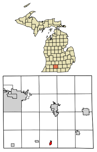
Stockbridge is a village in Ingham County in the U.S. state of Michigan. It is located within Stockbridge Township about 36 miles (58 km) southeast from downtown Lansing. The population was 1,218 at the 2010 census.
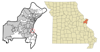
<span class="mw-page-title-main">Onsted, Michigan</span> Village in Michigan, United States

Onsted is a village within Lenawee County in the U.S. state of Michigan. The village had a population of 988 at the 2020 census. Located within the Irish Hills region, the village is part of Cambridge Township.

<span class="mw-page-title-main">Vandiver, Missouri</span> Village in Missouri, United States

Vandiver is a village in Audrain County, Missouri, United States. As of the 2010 census, the village population was 77.

<span class="mw-page-title-main">Wilbur Park, Missouri</span> Village in Missouri, United States

Wilbur Park is a village in St. Louis County, Missouri, United States. The population was 439 at the 2020 census.
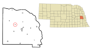
<span class="mw-page-title-main">Wayne Lakes, Ohio</span> Village in Ohio, United States

Wayne Lakes is a village in Darke County, Ohio, United States. The population was 693 at the 2020 census.

<span class="mw-page-title-main">Pleasant City, Ohio</span> Village in Ohio, United States

Pleasant City is a village in Guernsey County, Ohio, United States. The population was 400 at the 2020 census.

<span class="mw-page-title-main">Evendale, Ohio</span> Village in Ohio, United States

Evendale is a village in Hamilton County, Ohio, United States, within the Cincinnati metropolitan area. The population was 2,669 at the 2020 census.

<span class="mw-page-title-main">Hanover, Ohio</span> Village in Ohio, United States

Hanover is a village in Licking County, Ohio, United States. The population was 1,270 at the 2020 census. The village lies along Ohio State Route 16.

<span class="mw-page-title-main">Rocky Ridge, Ohio</span> Village in Ohio, United States

Rocky Ridge is a village in Ottawa County, Ohio, United States. The population was 312 at the 2020 census.

<span class="mw-page-title-main">Kettlersville, Ohio</span> Village in Ohio, United States

Kettlersville is a village in Shelby County, Ohio, United States. The population was 164 at the 2020 census.

<span class="mw-page-title-main">Pleasant Plain, Ohio</span> Village in Ohio, United States

Pleasant Plain is a village in Harlan Township, Warren County, Ohio, United States. The population was 129 at the 2020 census.

<span class="mw-page-title-main">Macksburg, Ohio</span> Village in Ohio, United States

Macksburg is a village in Washington County, Ohio, United States, along the West Fork of Duck Creek. The population was 120 at the 2020 census. The village is about 28 miles (45 km) south of Cambridge, Ohio.

<span class="mw-page-title-main">Walbridge, Ohio</span> Village in Ohio, United States

Walbridge is a village in Wood County, Ohio, United States, within the Toledo metropolitan area. The population was 3,011 at the 2020 census.

<span class="mw-page-title-main">Bellevue, Wisconsin</span> Village in Wisconsin, United States

Bellevue is a village in Brown County, Wisconsin. It was a town until incorporating as a village on February 14, 2003. The population was 15,935 at the time of the 2020 census. Bellevue is part of the Green Bay metropolitan area. Bellevue sits around 4.34 miles (6.99 km) east from central Green Bay.

<span class="mw-page-title-main">Friesland, Wisconsin</span> Village in Wisconsin, United States

Friesland is a village in Columbia County, Wisconsin, United States. The population was 320 at the 2020 census. It is part of the Madison Metropolitan Statistical Area, and was named after Friesland, one of the twelve provinces of the Netherlands.

<span class="mw-page-title-main">Dorchester, Wisconsin</span> Village in Wisconsin, United States

Dorchester is a village in Clark and Marathon counties in the U.S. state of Wisconsin, along the 45th parallel. It is part of the Wausau, Wisconsin Metropolitan Statistical Area. The population was 876 at the 2010 census. Of this, 871 were in Clark County, and only 5 were in Marathon County.

<span class="mw-page-title-main">Patch Grove, Wisconsin</span> Village in Wisconsin, United States

Patch Grove is a village in Grant County, Wisconsin, United States. The population was 198 at the 2010 census. The village is located within the Town of Patch Grove.

References

  1. "ArcGIS REST Services Directory". United States Census Bureau. Retrieved September 20, 2022.
  2. 1 2 U.S. Geological Survey Geographic Names Information System: Nellie, Ohio
  3. 1 2 "U.S. Census website". United States Census Bureau . Retrieved January 31, 2008.
  4. "US Gazetteer files 2010". United States Census Bureau. Archived from the original on January 25, 2012. Retrieved January 6, 2013.
  5. "Census of Population and Housing". Census.gov. Retrieved June 4, 2015.
  6. "U.S. Census website". United States Census Bureau . Retrieved January 6, 2013.