Gaar Corner | |
---|---|
Coordinates: 34°47′48″N96°51′43″W / 34.79667°N 96.86194°W | |
Country | United States |
State | Oklahoma |
County | Pontotoc |
Elevation | 1,011 ft (308 m) |
Time zone | UTC-6 (Central (CST)) |
• Summer (DST) | UTC-5 (CDT) |
GNIS feature ID | 1100438 [1] |
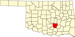
Gaar Corner is an Unincorporated community in the U.S. state of Oklahoma. [1] Gaar Corner is located in western Pontotoc County on State Highway 19, east of Stratford. While Gaar Corner is not shown on the official state map, it is marked by official ODOT place-name signs along SH-19.
Oklahoma is a state in the South Central region of the United States, bordered by the state of Texas to the south and west, Kansas to the north, Missouri to the northeast, Arkansas to the east, New Mexico to the west, and Colorado to the northwest. Partially in the western extreme of the Upland South, it is the 20th-most extensive and the 28th-most populous of the 50 United States. Its residents are known as Oklahomans and its capital and largest city is Oklahoma City. The state's name is derived from the Choctaw words okla, 'people' and humma, which translates as 'red'. Oklahoma is also known informally by its nickname, "The Sooner State", in reference to the Sooners, settlers who staked their claims in the Unassigned Lands before the Indian Appropriations Act of 1889 authorized the Land Rush of 1889.
Pontotoc County is in the south central part of Oklahoma. As of the 2020 census, the population was 38,065. Its county seat is Ada. The county was created at statehood from part of the Chickasaw Nation in Indian Territory. It was named for a historic Chickasaw tribal area in Mississippi. According to the Encyclopedia of Oklahoma History and Culture, Pontotoc is usually translated "cattail prairie" or "land of hanging grapes."
McCurtain County is in the southeastern corner of the U.S. state of Oklahoma. As of the 2020 census, its population was 30,814. Its county seat is Idabel. It was formed at statehood from part of the earlier Choctaw Nation in Indian Territory. The name honors an influential Choctaw family who lived in the area. Green McCurtain was the last chief when Oklahoma became a state in 1907.
Custer County is a county located in the U.S. state of Oklahoma. As of the 2020 census, the population was 28,513. Its county seat is Arapaho. The county was named in honor of General George Armstrong Custer.
Cotton County is a county located in the U.S. state of Oklahoma. As of the 2020 census, the population was 5,527. Its county seat is Walters. When Oklahoma achieved statehood in 1907, the area which is now Cotton County fell within the boundaries of Comanche County. It was split off in 1912, becoming the last county created in Oklahoma; it was named for the county's primary crop.
Canadian County is a county located in the U.S. state of Oklahoma. As of the 2020 census, the population was 154,405, making it the fourth most populous county in Oklahoma. Its county seat is El Reno.
Edmond is a city in Oklahoma County, Oklahoma, United States, and a part of the Oklahoma City metropolitan area in the central part of the state. The population was 94,428 according to the 2020 United States Census, a 16% increase from 2010. making it the fifth largest city in Oklahoma.
Oklahoma State University–Stillwater is a public land-grant research university in Stillwater, Oklahoma. OSU was founded in 1890 under the Morrill Act. Originally known as Oklahoma Agricultural and Mechanical College, it is the flagship institution of the Oklahoma State University System that holds more than 35,000 students across its five campuses with an annual budget of $1.7 billion. The main campus enrollment for the fall 2019 semester was 24,071, with 20,024 undergraduates and 4,017 graduate students. OSU is classified among "R1: Doctoral Universities – Very high research activity". According to the National Science Foundation, OSU spent $198.8 million on research and development in 2021.
In Utero is the third and final studio album by the American rock band Nirvana. It was released on September 21, 1993, by DGC Records. After breaking into the mainstream with their second album, Nevermind (1991), Nirvana hired Steve Albini to record In Utero, seeking a more complex, abrasive sound that was reminiscent of their work prior to Nevermind. Although frontman and primary songwriter Kurt Cobain claimed that the album was "very impersonal", many of its songs contain heavy allusions to his personal life and struggles, expressing feelings of angst that were common on the band's previous album.
U.S. Route 412 is an east–west United States highway, first commissioned in 1982. U.S. 412 overlaps expressway-grade Cimarron Turnpike from Tulsa west to Interstate 35 and the Cherokee Turnpike from 5 miles (8.0 km) east of Chouteau, Oklahoma, to 8 miles (13 km) west of the Arkansas state line. It runs the entire length of the Oklahoma Panhandle and traverses the Missouri Bootheel. Despite its numbering it is not associated with U.S. Route 12.
U.S. Route 56 is an east–west United States highway that runs for approximately 640 miles (1,030 km) in the Midwestern United States. US 56's western terminus is at Interstate 25 Business, US 412 and New Mexico State Road 21 in Springer, New Mexico and the highway's eastern terminus is at US 71 in Kansas City, Missouri. Much of it follows the Santa Fe Trail.
State Highway 95 is a state highway in the Panhandle region of the U.S. state of Oklahoma. This route, which is 42.1 miles (67.8 km) long, runs entirely through western Texas County. SH-95 does not have any lettered spur routes.
The Geography of Oklahoma encompasses terrain and ecosystems ranging from arid plains to subtropical forests and mountains. Oklahoma contains 10 distinct ecological regions, more per square mile than in any other state by a wide margin. It is situated in the Great Plains and U.S. Interior Highlands region near the geographical center of the 48 contiguous states. Usually considered part of the South Central United States, Oklahoma is bounded on the east by Arkansas and Missouri, on the north by Kansas, on the northwest by Colorado, on the far west by New Mexico, and on the south and near-west by Texas.
U.S. Highway 59 (US-59) heads along the eastern portion of the state of Oklahoma. US-59's 216.47-mile (348.37 km) route through Oklahoma takes it through the mountainous terrain of the eastern Oklahoma Ouachitas and Ozarks. US-59 serves several lakes and towns through Oklahoma's Green Country, including Grand Lake, a major recreation center. The route enters the state from Arkansas near Fogel, Arkansas, and ends at the Kansas state line south of Chetopa, Kansas.
U.S. Route 412 is a U.S. highway in the south-central portion of the United States, connecting Springer, New Mexico to Columbia, Tennessee. A 504.11-mile (811.29 km) section of the highway crosses the state of Oklahoma, traversing the state from west to east. Entering the state southwest of Boise City, US-412 runs the length of the Oklahoma Panhandle and serves the northern portion of the state's main body, before leaving the state at West Siloam Springs. Along the way, the route serves many notable cities and towns, including Boise City, Guymon, Woodward, Enid, and the state's second-largest city, Tulsa.
U.S. Route 64 (US-64) is a U.S. highway running from the Four Corners area to the Outer Banks of North Carolina. Between these two points, the highway passes through the entire width of Oklahoma; a total of 591.17 miles (951.40 km) of US-64 lies in the state of Oklahoma. US-64 enters the state from New Mexico, crossing the line between the two states between Clayton, New Mexico, and Boise City in Cimarron County. The route runs the full length of the Oklahoma Panhandle, then serves the northernmost tier of counties in the main body of the state before dipping southeastward to Tulsa, the state's second-largest city. From Tulsa, the highway continues southeast, leaving Oklahoma just west of Fort Smith, Arkansas. In addition to Tulsa, US-64 serves fifteen Oklahoma counties and the cities of Guymon, Woodward, Enid, and Muskogee.
Gaar or GAAR may refer to:
Chicken in the Rough, also known as Beverly's Chicken in the Rough, is a fried chicken restaurant chain and former franchise. It was one of the earliest restaurant chain franchises in the United States. Chicken in the Rough was founded by Beverly and Rubye Osborne in 1936 in Oklahoma City, and the restaurant's specialty, half a fried chicken dish, was also created in 1936. The dish itself was also referred to as "Chicken in the Rough", and consisted of half a fried chicken, shoestring potatoes and a biscuit with honey. Three restaurants presently serve the dish today, located in Oklahoma City, Port Huron, Michigan and Canadian neighbor Sarnia, Ontario. The chain's logo was an image of a rooster smoking a cigar and carrying a golf club. The chain also used a logo of "Chicken's Caddie", which depicted a chick acting as a golf caddie, stating "I'll gladly be fried for Chicken in the Rough".
Stephanie Irene Bice is an American politician serving as the U.S. representative for Oklahoma's 5th congressional district since 2021. A member of the Republican Party, she is the first Iranian American to be elected to Congress. Bice represented the 22nd district in the Oklahoma Senate from 2014 to 2020.