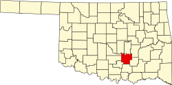
Happyland, Oklahoma

Last updated

Happyland
USA Oklahoma location map.svg
Red pog.svg
Happyland
Location within the state of Oklahoma
Usa edcp location map.svg
Red pog.svg
Happyland
Happyland (the United States)
Coordinates: 34°47′48″N96°32′58″W / 34.79667°N 96.54944°W / 34.79667; -96.54944
Country United States
State Oklahoma
County Pontotoc
Elevation
[1]
899 ft (274 m)
Time zone UTC-6 (Central (CST))
  Summer (DST) UTC-5 (CDT)
GNIS feature ID1100475 [1]

Happyland is an unincorporated community in Pontotoc County, Oklahoma, United States. [1] It is about 8 miles east of Ada on Oklahoma State Highway 1. [2]

Happyland has frequently been noted on lists of unusual place names. [3] [4] Sign theft of the Happyland sign has been reported. [5]

References

  1. 1 2 3 U.S. Geological Survey Geographic Names Information System: Happyland, Oklahoma
  2. "Ada, Oklahoma to Happyland, Oklahoma". Google Maps. Retrieved October 13, 2023.
  3. Bolton, Martha (February 8, 2006). The Cafeteria Lady Eats Her Way Across America: And Lives to Tell About It!. Gospel Light Publications. p. 76. ISBN   978-0-8307-3815-1.
  4. Simmons, Andy (August 16, 2012). Now That's Funny!: Jokes and Stories from the Man Who Keeps America Laughing. Reader's Digest. p. 117. ISBN   978-1-60652-504-3.
  5. Horcher, Gary (October 7, 2000). "Happyland". Oklahoman. Retrieved August 17, 2014.