Pickett, Oklahoma | |
|---|---|
 Pickett  Pickett | |
| Coordinates: 34°46′46″N96°46′32″W / 34.77944°N 96.77556°W | |
| Country | United States |
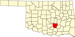
| State | Oklahoma |
| County | Pontotoc |
| Area | |
• Total | 3.23 sq mi (8.37 km2) |
| • Land | 3.23 sq mi (8.37 km2) |
| • Water | 0.00 sq mi (0.00 km2) |
| Elevation | 997 ft (304 m) |
| Population (2020) | |
• Total | 774 |
| • Density | 239.63/sq mi (92.53/km2) |
| Time zone | UTC-6 (Central (CST)) |
| • Summer (DST) | UTC-5 (CDT) |
| ZIP Code | 74820 (Ada) |
| Area code | 580 |
| FIPS code | 40-58650 |
| GNIS feature ID | 2812868 [2] |
Pickett is an unincorporated community and census-designated place (CDP) in Pontotoc County, Oklahoma, United States. It was first listed as a CDP prior to the 2020 census. [2]
Contents
The CDP is in west-central Pontotoc County, along Oklahoma State Highway 19, which leads east 5 miles (8 km) to Ada, the county seat, and west 10 miles (16 km) to Stratford.