
Prestonsburg is a home rule-class city in and the county seat of Floyd County, Kentucky, United States. The population was 3,255 at the time of the 2010 census, down from 3,612 at the 2000 census.
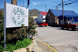
Allen is a home rule-class city in Floyd County, Kentucky, in the United States. The population was 193 at the 2010 census, up from 150 at the 2000 census.

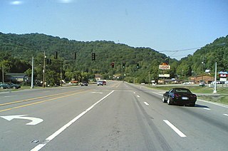
Warfield is a home rule-class city in Martin County, Kentucky, United States. The population was 284 at the 2000 census.

Coal Run Village is a home rule-class city in Pike County, Kentucky, in the United States. Bordered to the north, south, and east by Pikeville, the population was 1,706 at the 2010 census. It was the fastest-growing city in Kentucky from 2007 to 2008, with a population increase of 17.3%.
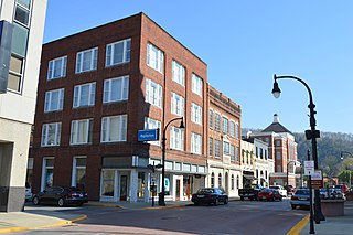
Pikeville is a city in and the county seat of Pike County, Kentucky, United States. During the 2010 U.S. Census, the population within Pikeville's city limits was 6,903. In Kentucky's current city classification system, Pikeville is a home rule-class city, a category that includes all of the state's more than 400 cities except for the two largest, Louisville and Lexington.

Big Sandy Community and Technical College (BSCTC), with its headquarters in Prestonsburg, Kentucky, is one of 16 two-year, open-admissions colleges of the Kentucky Community and Technical College System (KCTCS). It was created in 2003 from the consolidation of Prestonsburg Community College and Mayo Technical College. BSCTC maintains four campus locations: Prestonsburg Campus in Prestonsburg; Mayo Campus in Paintsville; Pikeville Campus in Pikeville; and Hager Hill Campus in Hager Hill.
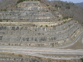
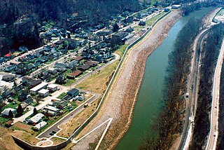
The Pikeville Cut-Through is a rock cut in Pikeville, Kentucky, United States created by the U.S. Army Corps of Engineers, through which passes a four-lane divided highway, a railroad line, and the Levisa Fork of the Big Sandy River. It is one of the largest civil engineering projects in the western hemisphere, moving nearly 18,000,000 cubic yards (14,000,000 m3) of soil and rock, compared to the Big Dig and the Panama Canal. Dr. William Hambley, who served as mayor of Pikeville for 29 years, Robert H. Holcomb, Chamber of Commerce president, and Henry Stratton, local attorney, spearheaded the project.
South Williamson is a census-designated place (CDP) in the Appalachian Mountains of northeastern Pike County, Kentucky, United States, on the border with West Virginia. It is separated from Williamson, West Virginia by the Tug Fork River. The community is located near U.S. Route 119 about 23 miles (37 km) east of Pikeville, Kentucky and 28 miles (45 km) southwest of Logan, West Virginia.

Virgie is a Census-designated place (CDP) located along Kentucky Route 1469 in Pike County, Kentucky, United States. Virgie's post office was established as Clintwood on April 3, 1890, with James M. Damron as postmaster. It was later renamed "Virgie" after the daughter of local resident, W.O.B. Ratliff, who was a lawyer and lumber dealer in Pikeville.

Dorton is an unincorporated community and coal town in southern Pike County, Kentucky, United States. Located along U.S. Route 23, also known as Country Music Highway, it lies at 37.27667°N, 82.57917°W at an altitude of 683 feet. It is centered at the confluence of Dorton and Shelby Creeks and the junction of U.S. 23 and KY 610, 13 miles south of Pikeville.

Coxs Creek is an unincorporated community along U.S. Routes 31E/150 in Nelson County, Kentucky, United States, 4½ miles north of the county seat of Bardstown. It is named for Colonel Isaac Cox of Pennsylvania, who built a "fort" at the site in April 1775 before he fought in the American Revolutionary War, with the help of his brother James. The land had actually been his father's, but David moved back to Virginia before he developed it. More of a station, Cox's 1,000 acres (4.0 km2) was said to be the first pioneer station in Nelson County. Isaac Cox would later be the last white man to be killed by Indians during the time of the great Indian wars in what later became Kentucky.
Drift, Kentucky is an unincorporated community and coal town in Floyd County, Kentucky, United States. As of the census of 2000, there were 569 people residing in the ZIP Code Tabulation Area (ZCTA) for Drift's ZIP code (41619).

River is an unincorporated community in Johnson County, Kentucky, United States. The post office was first established on September 6, 1890, and its current ZIP code is 41254. Its telephone area code is 606. Its geographic coordinates are.
Betsy Layne is a census-designated place (CDP) and coal town in Floyd County, Kentucky, United States. It was established in 1875 along the Levisa Fork. The post office opened on May 1, 1908, with Clayton L. Hitchins as postmaster. Its ZIP code is 41605. The 2010 census reported the population to be 688. Stage actress Bette Henritze is a native of Betsy Layne.
Beefhide is an unincorporated community spanning across a county line between Letcher County and Pike County, Kentucky, United States.
Oldtown is an unincorporated community in Greenup County, in the U.S. state of Kentucky.
Richardson is an unincorporated community in Lawrence County, in the U.S. state of Kentucky.
Risner is an unincorporated community in Floyd County, in the U.S. state of Kentucky.
Robinson Creek is a stream located within Pike County, Kentucky. It is a tributary of Shelby Creek.


