
Breathitt County is a county located in the eastern Appalachian portion of the U.S. state of Kentucky. As of the 2010 census, the population was 13,878. Its county seat is Jackson, Kentucky. The county was formed in 1839 and was named for John Breathitt, who was Governor of Kentucky from 1832 to 1834. Breathitt County was a prohibition or dry county, until a public vote in July 2016 that allowed alcohol sales.

The Cumberland River is a major waterway of the Southern United States. The 688-mile-long (1,107 km) river drains almost 18,000 square miles (47,000 km2) of southern Kentucky and north-central Tennessee. The river flows generally west from a source in the Appalachian Mountains to its confluence with the Ohio River near Paducah, Kentucky, and the mouth of the Tennessee River. Major tributaries include the Obey, Caney Fork, Stones, and Red rivers.

The Kentucky River is a tributary of the Ohio River, 260 miles (418 km) long, in the U.S. Commonwealth of Kentucky. The river and its tributaries drain much of the central region of the state, with its upper course passing through the coal-mining regions of the Cumberland Mountains, and its lower course passing through the Bluegrass region in the north central part of the state. Its watershed encompasses about 7,000 square miles (18,000 km2). It supplies drinking water to about one-sixth of the population of the Commonwealth of Kentucky.

The Cumberland Mountains are a mountain range in the southeastern section of the Appalachian Mountains. They are located in western Virginia, eastern edges of Kentucky, and eastern middle Tennessee, including the Crab Orchard Mountains. Their highest peak, with an elevation of 4,223 feet (1,287 m) above mean sea level, is High Knob, which is located near Norton, Virginia.

The Tug Fork is a tributary of the Big Sandy River, 159 miles (256 km) long, in southwestern West Virginia, southwestern Virginia, and eastern Kentucky in the United States. Via the Big Sandy and Ohio rivers, it is part of the watershed of the Mississippi River.

The Levisa Fork is a tributary of the Big Sandy River, approximately 164 miles (264 km) long, in southwestern Virginia and eastern Kentucky in the United States.

Carr Creek Lake, located east of Hazard, Kentucky, along Kentucky Route 15 in Knott County, is a 710 acres (3 km2) reservoir created by the U.S. Army Corps of Engineers in 1976. Carr Creek Lake's earth and rock fill dam is 130 ft (40 m) tall and 720 ft (219 m) long, and the dam is located 8.8 mi (14 km) above the mouth of Carr Fork River, a tributary of the North Fork Kentucky River.

The Big South Fork National River and Recreation Area preserves the Big South Fork of the Cumberland River and its tributaries in northeastern Tennessee and southeastern Kentucky. In addition, the former mining community of Blue Heron is preserved and interpreted via signage.

Breaks Interstate Park is a bi-state state park located partly in southeastern Kentucky and mostly in southwestern Virginia, in the Jefferson National Forest, at the northeastern terminus of Pine Mountain. Rather than their respective state park systems, it is instead administered by an interstate compact between the states of Virginia and Kentucky. It is one of several interstate parks in the United States, but only one of two operated jointly under a compact rather than as two separate state park units. The Virginia Department of Conservation and Recreation and the Kentucky Department of Parks are still major partner organizations, however.

Blue Heron, also known as Mine 18, is a former coal mining community or coal town on the banks of the Big South Fork of the Cumberland River in McCreary County, Kentucky, United States, that has been recreated and is maintained as an interpretive history area in the Big South Fork National River and Recreation Area.
The New Haven Battlefield is the area of American Civil War engagement (military)s at the intersection of the Rolling Fork and the former Louisville and Nashville Railroad line between Knoxville and New Haven, Kentucky. The geographic area includes the James Howell Farm and additional combat areas of December 30, 1862.
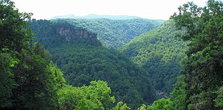
The Russell Fork is a 51.9-mile-long (83.5 km) tributary of the Levisa Fork in southwestern Virginia and southeastern Kentucky in the United States. Known for its whitewater, it rises in the Appalachian Mountains of southwest Virginia, in southern Dickenson County, and flows north through the town of Haysi, Virginia, the Breaks Interstate Park, and the town of Elkhorn City, Kentucky, in Pike County, where it flows into the Levisa Fork which, together with the Tug Fork, form the Big Sandy River.
Right Fork of Meathouse is an unincorporated community in Pike County, Kentucky, United States. Right Fork of Meathouse is located on Pigpen Branch, the right fork of Meathouse Fork, 12.7 miles (20.4 km) east-northeast of Pikeville.
Right Fork is an unincorporated community in Morgan County, Kentucky, United States.
Kentucky Route 205 (KY 205) is a 7.1-mile-long (11.4 km) state highway in the U.S. state of Kentucky. The highway connects mostly rural areas of Breathitt, Wolfe, and Morgan counties with Jackson, Vancleve, and Helechawa.
Kentucky Route 306 (KY 306) is a 2.1-mile-long (3.4 km) state highway in the U.S. state of Kentucky. The highway travels south-to-north, mostly in Wheelwright, within Floyd County.
Kentucky Route 378 (KY 378) is a 20.618-mile-long (33.181 km) state highway in the U.S. state of Kentucky. The highway travels through mostly rural areas of Breathitt and Magoffin counties.


