
Catlettsburg is a home rule-class city in and the county seat of Boyd County, Kentucky, United States. The city population was 1,780 at the 2020 census. It is part of the Huntington–Ashland metropolitan area.
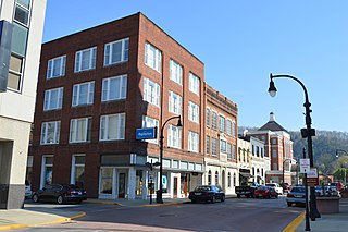
Pikeville is a home rule-class city in and the county seat of Pike County, Kentucky, United States. The population of Pikeville was 7,754 as of the 2020 U.S. Census. Pikeville serves as a regional economic, educational and entertainment hub for the surrounding areas of eastern Kentucky, Virginia and West Virginia. It is home to the University of Pikeville and the Pikeville Cut-Through, the second-largest earthmoving project in the western hemisphere.

The Hatfield–McCoy feud, also described by journalists as the Hatfield–McCoy conflict, involved two American families of the West Virginia–Kentucky area along the Tug Fork of the Big Sandy River from 1863 to 1891. The Hatfields of West Virginia were led by William Anderson "Devil Anse" Hatfield, while the McCoys of Kentucky were under the leadership of Randolph "Ole Ran'l" McCoy. Those involved in the feud were descended from Joseph Hatfield and William McCoy (born c. 1750). The feud has entered the American folklore lexicon as a metonym for any bitterly feuding rival parties.

Hatfield Government Center is a light rail station on the in downtown Hillsboro, Oregon, United States, owned and operated by TriMet. The station is the western terminus of the MAX Blue Line. Opened in 1998, it is located in the same block as the Hillsboro Post Office and adjacent to the Washington County Courthouse and the Hillsboro Civic Center. The block is bounded by First and Adams streets on the east and west and Washington and Main streets on the south and north. The station is named in honor of Mark O. Hatfield, a former United States Senator from Oregon and light rail proponent. It is the furthest west light rail station in the Continental United States.

Hatfield is an unincorporated community in northwestern Harrison County, Missouri, United States. It is located approximately twelve miles east of Grant City on Route 46.

William Sidney Hatfield, was a West Virginia law enforcement officer noted for his involvement in bitter labor disputes, on the side of labor, during the Coal Wars of the early 20th century.
Nokomis is a town in the Canadian province of Saskatchewan.
Neatsville is an unincorporated community in Adair County, in the U.S. state of Kentucky. It is located at the junction of Kentucky Route 206 and Kentucky Route 76. Its elevation is 705 feet (215 m). For unknown reasons, the town's name was spelled as Neetsville from 1876 until 1886, when the town's post office closed. In its early history from around the 1810s to 1900, Neatsville progressively grew to become a well-established, incorporated town. It has been relocated twice through the years, once due to flooding circa 1900–1902, which decimated the town, and once in the 1960s when the Green River was impounded to make way for the Green River Reservoir.
Wharncliffe is an unincorporated community in Mingo County, West Virginia, United States. It is 7 miles (11 km) southwest of Gilbert, and has a post office with ZIP code 25651.

Colmar is a suburban unincorporated community located in Montgomery County, Pennsylvania, United States, along State Route 309 just northeast of Lansdale. The West Branch Neshaminy Creek forms the community's natural northern boundary and flows eastward into the Neshaminy Creek. It is located in Hatfield and Montgomery Townships. It is served by the North Penn School District and is part of the North Penn Valley region that is centered on the borough of Lansdale. Colmar is important to transportation in the northern Delaware Valley due to its location on Route 309 and having the Colmar station on the Lansdale/Doylestown Line of SEPTA Regional Rail. While Colmar has its own post office, with the ZIP code of 18915, nearby areas use the Hatfield ZIP code of 19440 or the Lansdale ZIP code of 19446.
Line Lexington is an unincorporated community located in the Delaware Valley on Route 309 in Bucks and Montgomery counties in Pennsylvania, United States. It is split between the Bucks County townships of Hilltown and New Britain and the Montgomery County township of Hatfield. The Montgomery County portion of the village is in the North Penn School District and is part of the North Penn Valley region that is centered on the borough of Lansdale. The Bucks County portion is also served by the North Penn School District. While it has its own post office with the ZIP code of 18932, portions use the Colmar ZIP code of 18915, the Chalfont ZIP code of 18914 or the Hatfield ZIP code of 19440. It is served by SEPTA Suburban Bus Route 132 and the nearest SEPTA Regional Rail stations are nearby in Colmar and Chalfont on the Lansdale/Doylestown Line. The Line Lexington telephone exchange uses area code 215.

Hatfields & McCoys is a 2012 American three-part Western television miniseries based on the Hatfield–McCoy feud produced by History channel. The two-hour episodes aired on May 28, 29, and 30, 2012.
Fusonia is an unincorporated community and coal town in Perry County, Kentucky, United States.
Hardburly is an unincorporated community and coal town in Perry County, Kentucky, United States.
Christopher is an unincorporated community and coal town in Perry County, Kentucky, United States. Their Post Office has been closed.
Beefhide is an unincorporated community spanning across a county line between Letcher County and Pike County, Kentucky, United States.

Hardy is an unincorporated community and coal town in Pike County, Kentucky, United States.
Meta is an unincorporated community in Pike County, Kentucky. Meta is located at the junction of Kentucky Route 1426 and Kentucky Route 2169 7.7 miles (12.4 km) northeast of Pikeville. The community had a post office from 1896 to 1959.
Unionville is a suburban community in the Delaware Valley located on Pennsylvania Route 309. It is mainly in Hatfield Township, Montgomery County but also in Hilltown Township, Bucks County, Pennsylvania, United States.
Piso is an unincorporated community located in Pike County, Kentucky, United States. Their post office has been closed. The community was named by Bud Williamson after viewing an advertisement for medicine in an almanac.


