
Buchanan County is a United States county in far western Virginia, the only county in the state to border both West Virginia and Kentucky. The county is part of the Southwest Virginia region and lies in the rugged Appalachian Plateau portion of the Appalachian Mountains. Its county seat is Grundy. Buchanan County was established in 1858 from parts of Russell and Tazewell counties, and it was named in honor of then-President James Buchanan. Local pronunciation differs from that of the 15th president's surname; here the county is pronounced as "Búh-can-nin". In 1880, part of Buchanan County was taken to form Dickenson County.

Pike County is a county in the U.S. state of Kentucky. As of the 2020 Census, the population was 58,669. Its county seat is Pikeville. The county was founded in 1821. It is a moist county—a county in which alcohol sales are prohibited but which contains a "wet" city. In three of the county's cities—Pikeville, Elkhorn City, and Coal Run Village—package alcohol sales are legal.

Johnson County is a county located in the U.S. state of Kentucky. As of the 2020 census, the population was 22,680. Its county seat is Paintsville. The county was formed in 1843 and named for Richard Mentor Johnson, a colonel of the War of 1812, United States Representative, Senator, and Vice President of the United States.

Redan is an unincorporated community and census-designated place (CDP) in DeKalb County, Georgia, United States. As of the 2020 census, the CDP had a total population of 31,749. It is a predominantly African American community in eastern DeKalb County, and is a suburb of Atlanta.

Mount Washington is a home rule-class city in northeast Bullitt County, Kentucky, in the United States. The population was 18,090 at the 2020 census. The city is one of several surrounding Louisville that have experienced a sharp rise in population in the past three decades, becoming a commuter town.

Morgantown is a home rule-class city in, and the seat of Butler County, Kentucky, United States. The population was 2,471 at the time of the 2020 Census.

Cold Spring is a home rule-class city in Campbell County, Kentucky, in the United States. The population was 6,216 at the 2020 census. It is part of the Cincinnati-Northern Kentucky metropolitan area.

Harlan is a home rule-class city in and the county seat of Harlan County, Kentucky, United States. The population was 1,745 at the 2010 census, down from 2,081 at the 2000 census.

Cynthiana is a home rule-class city in Harrison County, Kentucky, in the United States. The population was 6,402 at the 2010 census. It is the seat of its county.

Independence is a home rule-class city in Kenton County, Kentucky, United States. It is one of its county's two seats of government. The population was 28,676 at the time of the 2020 census. It is the third largest city in Northern Kentucky after Covington and Florence, and is part of the Cincinnati metropolitan area.

Barbourville is a home rule-class city in Knox County, Kentucky, in the United States. The population was 3,165 at the 2010 census, down from 3,589 at the 2000 census. It is the county seat of Knox County. The city was formally established by the state assembly in 1812. It was incorporated in 1854 and then reincorporated in 1856.

Louisa is a home-rule class city located in eastern Kentucky, United States, at the merger of the Levisa and Tug Forks into the Big Sandy River, which forms part of the state's border with West Virginia. It is the seat of Lawrence County. The population was 2,467 at the 2010 census and an estimated 2,375 in 2018.

Vanceburg is a home rule-class city in Lewis County, Kentucky, United States, along the Ohio River. The population was 1,428 at the 2020 census. It is the county seat of Lewis County.
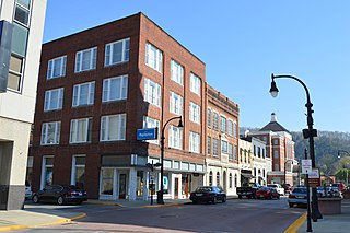
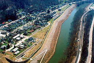
Pikeville is a home rule-class city in and the county seat of Pike County, Kentucky, United States. Its population was 7,754 as of the 2020 U.S. Census. Pikeville serves as a regional economic, educational, and entertainment hub for the surrounding areas of eastern Kentucky, Virginia, and West Virginia. It is home to the University of Pikeville and the Pikeville Cut-Through, the second-largest earthmoving project in the Western Hemisphere.

Franklin is a home rule-class city in and the county seat of Simpson County, Kentucky, United States. The county is located on the south central border of the state, and its population was 10,176 at the 2020 census.
South Williamson is a unincorporated community in the Appalachian Mountains of northeastern Pike County, Kentucky, United States, on the border with West Virginia. It is separated from Williamson, West Virginia by the Tug Fork River. The community is located near U.S. Route 119 about 23 miles (37 km) east of Pikeville, Kentucky and 28 miles (45 km) southwest of Logan, West Virginia.

Shelby Valley High School (SVHS) is a public high school located in Pike County, Kentucky, United States. The school campus is situated on flat land in the rugged mountains of eastern Kentucky. There are 597 students currently enrolled in grades 9–12. Located approximately ten miles south of Pikeville on US 23, the school receives students from three elementary schools and two middle schools.

Otwell is an unincorporated census-designated place in Jefferson Township, Pike County, in the U.S. state of Indiana.

Dorton is an unincorporated community and coal town in southern Pike County, Kentucky, United States. Located along U.S. Route 23, also known as Country Music Highway. It is centered at the confluence of Dorton and Shelby Creeks and the junction of U.S. 23 and KY 610, 13 miles south of Pikeville.

Belfry is an unincorporated community and census-designated place in Pike County, Kentucky. Belfry is located on U.S. Route 119, 16.8 miles (27.0 km) northeast of Pikeville. Belfry has a post office with ZIP code 41514, which opened on February 26, 1921. The origin of the name "Belfry" is obscure.


