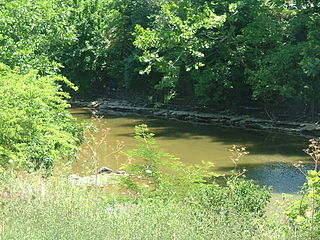
Lick Creek | |
---|---|
Unincorporated community | |
Coordinates: 37°22′49″N82°17′50″W / 37.38028°N 82.29722°W Coordinates: 37°22′49″N82°17′50″W / 37.38028°N 82.29722°W | |
Country | United States |
State | Kentucky |
County | Pike |
Elevation | 925 ft (282 m) |
Time zone | Eastern (EST) (UTC-5) |
• Summer (DST) | EDT (UTC-4) |
ZIP codes | 41540 |
GNIS feature ID | 508455 [1] |
Lick Creek is an unincorporated community located in Pike County, Kentucky, United States.
In law, an unincorporated area is a region of land that is not governed by a local municipal corporation; similarly an unincorporated community is a settlement that is not governed by its own local municipal corporation, but rather is administered as part of larger administrative divisions, such as a township, parish, borough, county, city, canton, state, province or country. Occasionally, municipalities dissolve or disincorporate, which may happen if they become fiscally insolvent, and services become the responsibility of a higher administration. Widespread unincorporated communities and areas are a distinguishing feature of the United States and Canada. In most other countries of the world, there are either no unincorporated areas at all, or these are very rare; typically remote, outlying, sparsely populated or uninhabited areas.
Pike County is a county located in the U.S. state of Kentucky. As of the 2010 census, the population was 65,024. Its county seat is Pikeville. The county was founded in 1821.
Kentucky, officially the Commonwealth of Kentucky, is a state located in the east south-central region of the United States. Although styled as the "State of Kentucky" in the law creating it, (because in Kentucky's first constitution, the name state was used) Kentucky is one of four U.S. states constituted as a commonwealth. Originally a part of Virginia, in 1792 Kentucky became the 15th state to join the Union. Kentucky is the 37th most extensive and the 26th most populous of the 50 United States.
Big Bone is an unincorporated community in southern Boone County, Kentucky, United States. It is bounded on the west by the Ohio River, and Rabbit Hash, on the south by Big Bone Creek, which empties into the river at Big Bone Landing. The northern extent is along Hathaway Road, and the eastern portion extends not further than U.S. 42, and is approached from that direction by Beaver Road coming from either Richwood or Walton. Big Bone took its name from a nearby prehistoric mineral lick of the same name. Geographical features of interest include Big Bone Lick State Park and the now disappeared Big Bone Island.
Silver Creek is a large creek that flows for approximately 40 miles (64 km) through Madison County, Kentucky, in the United States.
Mouthcard is a small unincorporated community in Pike County, Kentucky, United States near the Virginia state line. It lies on the Levisa Fork River of the Big Sandy River in the heart of the Appalachians. U.S. Route 460 runs through Mouthcard to meet U.S. Route 23 in Pikeville, the county seat.
The Office of Kentucky Nature Preserves is an agency of the Commonwealth of Kentucky in the United States dedicated to the protection of Kentucky's natural heritage. It oversees a statewide program of nature preserves, Kentucky Wild Rivers Program, and the "Nature's Finest" license plate program of the Kentucky Heritage Land Conservation Fund Board. The program was formerly known as the "Kentucky State Nature Preserves Commission", from 1976 until a reorganization in 2018.
The Licking River is a partly navigable, 303-mile-long (488 km) tributary of the Ohio River in northeastern Kentucky in the United States. The river and its tributaries drain much of the region of northeastern Kentucky between the watersheds of the Kentucky River to the west and the Big Sandy River to the east. The North Fork Licking River, in Pendleton County, Kentucky is one of its tributaries.
Yellow Creek may refer to:
Knob Lick is an unincorporated community in Metcalfe County, Kentucky, United States. Knob Lick is located on Kentucky Route 70, 8 miles (13 km) northwest of Edmonton. Knob Lick has a post office with ZIP code 42154. Knob lick was named by a salt lick near the knob hill where the rock quarry now is. It was founded in 1977 by Kenneth Chapman when he rode in on his trusty 1066.
Saltlick Creek or Salt Lick Creek may refer to:
Hueysville, also known as Bosco, is an unincorporated community in Floyd County, Kentucky, United States, located on Salt Lick Creek Road west of Kentucky Route 550. CSX Transportation's E&BV Subdivision passes through Hueysville.
Five Lick Creek was an unincorporated community within Robertson County, Kentucky, United States.
Lick Creek may refer to:
Salt Lick Creek is a stream in Lewis County, Kentucky, in the United States. It is a tributary of the Ohio River.
Kentucky Route 198 (KY 198) is a 12.5-mile-long (20.1 km) state highway in the U.S. state of Kentucky. The highway connects Yosemite and Turnersville with mostly rural areas of Casey and Lincoln counties.
Kentucky Route 211 (KY 211) is a 7.1-mile-long (11.4 km) state highway in the U.S. state of Kentucky. The highway is split into two segments, separated by the Licking River. The southern segment connects mostly rural areas of Bath County with Salt Lick. The northern segment, which is significantly shorter, is in rural Rowan County.
Kentucky Route 324 (KY 324) is a 10.8-mile-long (17.4 km) state highway in the U.S. state of Kentucky. The highway connects mostly rural areas of Mason County with Mays Lick.
Kentucky Route 344 (KY 344) is a 20.920-mile-long (33.667 km) state highway in the U.S. state of Kentucky. The highway travels through mostly rural areas of Fleming and Lewis counties
This Pike County, Kentucky state location article is a stub. You can help Wikipedia by expanding it. |