Lodge Grass is a town in Big Horn County, Montana, United States. The population was 441 at the 2020 census.

The Little Bighorn River is a 138-mile-long (222 km) tributary of the Bighorn River in the United States in the states of Montana and Wyoming. The Battle of the Little Bighorn, also known as the Battle of the Greasy Grass, was fought on its banks on June 25–26, 1876, as well as the Battle of Crow Agency in 1887.

Corridor Q is a highway in the U.S. states of Kentucky, Virginia, and West Virginia. It is part of the Appalachian Development Highway System and U.S. Route 460. Corridor Q runs from Corridor B near Pikeville, Kentucky, easterly to Interstate 81 in Christiansburg, Virginia.
Elsie is an unincorporated community in Magoffin County, Kentucky, United States. It lies along U.S. Route 460 northwest of the city of Salyersville, the county seat of Magoffin County. It sits along a stretch of the Licking River and includes the side valleys of Wolf Branch, Buck Branch, Cripple Creak, and Greasy Creak. Its elevation is 850 feet (259 m).
The 3rd Regiment Kentucky Volunteer Infantry was an infantry regiment that served in the Union Army during the American Civil War.
The 12th Kentucky Cavalry Regiment was a cavalry regiment that served in the Union Army during the American Civil War.
Eula Hall was an Appalachian activist and healthcare pioneer who founded the Mud Creek Clinic in Grethel in Floyd County, Kentucky.

Shelbiana is an unincorporated community and coal town in Pike County, Kentucky, United States.

Kentucky Route 221 (KY 221) is a 42.5-mile-long (68.4 km) state highway in the U.S. state of Kentucky. The highway connects mostly rural areas of Bell, Harlan, Perry, and Leslie counties with the Daniel Boone National Forest.

Kentucky Route 225 (KY 225) is a 16.4-mile-long (26.4 km) state highway in the U.S. state of Kentucky. The highway connects mostly rural areas of Bell and Knox counties with Barbourville.
Greasy Creek may refer to:
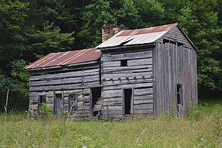
The John Shell Cabin, in Leslie County, Kentucky, located south of Chappell, Kentucky on Greasy Creek Road, was listed on the National Register of Historic Places in 1975.
Dehart is an unincorporated community in Morgan County, Kentucky, United States.

Kentucky Route 764 (KY 764) is a 18.697-mile-long (30.090 km) rural secondary state highway in southern Daviess County and northern Ohio County. It begins at a junction with U.S. Route 231 south of Masonville. The road heads to Pleasant Ridge and intersects KY 2115. The road then heads easterly and then passes under Interstate 165. KY 764 intersects KY 762, then it passes over the Greasy Creek. It finally intersects KY 1738 before passing back into Daviess County, where it enters the community of Oklahoma. The road goes to Whitesvile, running concurrently with KY 54. KY 764 separates from KY 54, and then intersects KY 2157, and after a few miles, it ends at KY 144 west of Pellville. The first few miles are signed as east–west, with the remaining signed as north–south.


