
Perry County is a county located in the U.S. state of Kentucky. As of the 2010 census, the population was 28,712. Its county seat is Hazard. The county was founded in 1820. Both the county and county seat are named for Commodore Oliver Hazard Perry, a naval hero in the War of 1812.

McCreary County is a county located in the U.S. state of Kentucky. As of the 2010 census, the population was 18,306. Its county seat is Whitley City. The county is named for James B. McCreary, a Confederate war hero and two-time Governor of Kentucky. During his second term as Governor, McCreary County was created by the Legislature and was named in his honor.

Hopkins County is a county located in the western part of the U.S. state of Kentucky. As of the 2010 census, the population was 46,920. Its county seat is Madisonville. The county was formed in 1806 and named for General Samuel Hopkins, an officer in both the American Revolutionary War and War of 1812, and later a Kentucky legislator and U.S. Congressman.

Harlan County is a county located in southeastern Kentucky. As of the 2010 census, the population was 29,278. Its county seat is Harlan.

The West Kentucky Coal Field comprises an area in the west-central and northwestern part of the state, bounded by the Dripping Springs Escarpment and the Pennyroyal Plateau and the Ohio River, but is part of the Illinois Basin that extends into Indiana and Illinois. It is characterized by Pennsylvanian age sandstones, shales and coal. Nearly all of the counties in the area are part of the television market known as the Kentucky–Illinois–Indiana tri-state area.

Lookout Mountain is a mountain ridge located at the northwest corner of the U.S. state of Georgia, the northeast corner of Alabama, and along the Tennessee state line in Chattanooga. Lookout Mountain was the scene of the "Last Battle of the Cherokees" during the Nickajack Expedition, which took place in the 18th century, as well as the November 24, 1863 Battle of Lookout Mountain during the American Civil War.

Black Mountain is the highest mountain peak in the Commonwealth of Kentucky, United States, with a summit elevation of 4,145 feet (1,263 m) above mean sea level and a top-to-bottom height of over 2,500 feet (760 m). The summit is located at approximately 36°54′51″N82°53′38″W in Harlan County, Kentucky near the Virginia border, just above the towns of Lynch, Kentucky and Appalachia, Virginia. It is about 500 feet (150 m) taller than any other mountain in Kentucky.

Appalachian music is the music of the region of Appalachia in the Eastern United States. It is derived from various European and African influences, including English ballads, Irish and Scottish traditional music, hymns, and African-American blues. First recorded in the 1920s, Appalachian musicians were a key influence on the early development of Old-time music, country music, and bluegrass, and were an important part of the American folk music revival of the 1960s. Instruments typically used to perform Appalachian music include the banjo, American fiddle, fretted dulcimer, and guitar.

Mount Lookout, Ohio is one of the Eastern neighborhoods of Cincinnati, just northwest of Linwood and overlooking the Ohio River valley. The neighborhood is named for the Mount Lookout Observatory, which moved to the neighborhood in 1873. The population was 4,814 at the 2010 census.

Point Lookout Light is a lighthouse that marks the entrance to the Potomac River at the southernmost tip of Maryland's western shore of the Chesapeake Bay, south of the town of Scotland in Saint Mary's County, Maryland. It is known for its association with ghost stories and has been the subject of paranormal investigations.

Stone is an unincorporated community and coal town in Pike County, Kentucky, United States. It was established in 1912. Stone was a mining community named for Galen Stone, head of the Pond Creek Coal Company which was based in Stone. In 1922 the Pond Creek Coal Company was sold to Fordson Coal Company, which was a subsidiary of Ford Motor Company. In 1936 Fordson sold the mine at Stone to Eastern Coal Company.
Lookout was an American Thoroughbred racehorse that is best known for winning the 1893 Kentucky Derby.
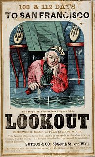
Lookout was an 1853 clipper known for her passages from New York to San Francisco, and as an offshore and coastal trader in the lumber and coal trades.

The Kentucky Coal Museum is heritage center located in Benham, Kentucky. Its focus is the history of the coal industry in Eastern Kentucky, featuring specific exhibits on the company towns of Benham and neighboring Lynch. It is housed in a former company store that was built by International Harvester in 1923. In June 1990, the Tri-City Chamber of Commerce purchased the building for the future site of the museum. After receiving additional grants from the state of Kentucky, the museum opened in May 1994.
Barthell is a former coal town in McCreary County, Kentucky, United States. It was established in 1902 and was the first of 18 mining camps to be built by the Stearns Coal and Lumber Company. It now serves as an open-air history museum, which is open from April through Thanksgiving.
Glomawr is an unincorporated community located in Perry County, Kentucky, United States.
Closplint is an unincorporated community in Harlan County, Kentucky, United States. The settlement was named Cloversplint after the seam of coal and the mining company that built it as a coal town in 1926 , and operated there between 1928 and 1946 . When the United States Postal Service established a post office, the name was shortened to Closplint.
Fourseam is an unincorporated community located in Perry County, Kentucky, United States.
Black Star Coal Camp is an unincorporated community and coal town in Harlan County, Kentucky, United States.


