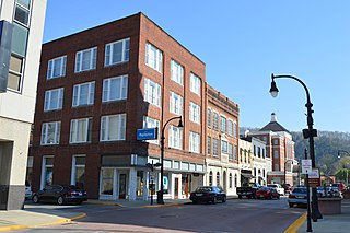
Marrowbone | |
---|---|
Unincorporated community | |
Coordinates: 37°21′57″N82°24′50″W / 37.36583°N 82.41389°W Coordinates: 37°21′57″N82°24′50″W / 37.36583°N 82.41389°W | |
Country | United States |
State | Kentucky |
County | Pike |
Elevation | 755 ft (230 m) |
Time zone | Eastern (EST) (UTC-5) |
• Summer (DST) | EDT (UTC-4) |
ZIP codes | 41559 |
GNIS feature ID | 517534 [1] |
Marrowbone is an unincorporated community located in Pike County, Kentucky, United States. It was also known as Regina.
In law, an unincorporated area is a region of land that is not governed by a local municipal corporation; similarly an unincorporated community is a settlement that is not governed by its own local municipal corporation, but rather is administered as part of larger administrative divisions, such as a township, parish, borough, county, city, canton, state, province or country. Occasionally, municipalities dissolve or disincorporate, which may happen if they become fiscally insolvent, and services become the responsibility of a higher administration. Widespread unincorporated communities and areas are a distinguishing feature of the United States and Canada. In most other countries of the world, there are either no unincorporated areas at all, or these are very rare; typically remote, outlying, sparsely populated or uninhabited areas.
Pike County is a county located in the U.S. state of Kentucky. As of the 2010 census, the population was 65,024. Its county seat is Pikeville. The county was founded in 1821.
Kentucky, officially the Commonwealth of Kentucky, is a state located in the east south-central region of the United States. Although styled as the "State of Kentucky" in the law creating it, (because in Kentucky's first constitution, the name state was used) Kentucky is one of four U.S. states constituted as a commonwealth. Originally a part of Virginia, in 1792 Kentucky became the 15th state to join the Union. Kentucky is the 37th most extensive and the 26th most populous of the 50 United States.
Pikeville is a city in and the county seat of Pike County, Kentucky, United States. During the 2010 U.S. Census, the population within Pikeville's city limits was 6,903. In Kentucky's current city classification system, Pikeville is a home rule-class city, a category that includes all of the state's more than 400 cities except for the two largest, Louisville and Lexington.
U.S. Route 68 is a United States highway that runs for 560 miles (900 km) from northwest Ohio to Western Kentucky. The highway's western terminus is at US 62 in Reidland, Kentucky. Its present northern terminus is at Interstate 75 in Findlay, Ohio, though the route once extended as far north as Toledo. US 68 intersects with US 62 three times during its route. It is signed east–west in Kentucky and north–south in Ohio.
Marrowbone Township is located in Moultrie County, Illinois. As of the 2010 census, its population was 1,730 and it contained 751 housing units.
Marrowbone is a census-designated place in Cumberland County, Kentucky, United States. As of the 2010 census it had a population of 217. It has a post office, with the ZIP code of 42759.
The 39th Kentucky Volunteer Infantry Regiment was an infantry regiment that served in the Union Army during the American Civil War.
Marrowbone, Kentucky may refer to the following places in the U.S. state of Kentucky:
Lookout is an unincorporated community and coal town located in Pike County, Kentucky, United States. It was also known as the Marrowbone Coal Mine. Its post office closed in January 2011
Little Floyd County is an unincorporated community in Pike County, Kentucky, United States. Little Floyd County is located on Mare Creek 7.3 miles (11.7 km) northwest of Pikeville.
Aflex is an unincorporated community and coal town in Pike County, Kentucky, United States.
Beefhide is an unincorporated community spanning across a county line between Letcher County and Pike County, Kentucky, United States.
Hellier is an unincorporated community and coal town in Pike County, Kentucky, United States. Hellier was featured in an independent documentary called "Hellier". It is a five part series that follows the investigation and research of the Kentucky goblins. Dana & Greg Newkirk, owners of The Travelling Museum of the Paranormal and the Occult, lead the investigation. Along with Conner James Randall and Karl Pfieffer.
Meta is an unincorporated community in Pike County, Kentucky. Meta is located at the junction of Kentucky Route 1426 and Kentucky Route 2169 7.7 miles (12.4 km) northeast of Pikeville. The community had a post office from 1896 to 1959.
Canada is an unincorporated community in Pike County, Kentucky. Canada is located on U.S. Route 119, 13.8 miles (22.2 km) northeast of Pikeville.
Marrowbone may refer to the following places:
Robinson Creek is an unincorporated community located in Pike County, Kentucky, United States.
The Cincinnati metropolitan area, informally known as Greater Cincinnati or the Greater Cincinnati Tri-State Area, is a metropolitan area that includes counties in the U.S. states of Ohio, Kentucky, and Indiana around the Ohio city of Cincinnati. The United States Census Bureau's formal name for the area is the Cincinnati–Middletown, OH–KY–IN Metropolitan Statistical Area. As of the 2010 U.S. Census, this MSA had a population of 2,114,580, making Greater Cincinnati the 29th most populous metropolitan area in the United States, the first largest metro area entirely in Ohio, followed by Cleveland (2nd) and Columbus (3rd).
Kentucky Route 195 (KY 195) is a 11.6-mile-long (18.7 km) state highway in the U.S. state of Kentucky. The highway connects Ashcamp with Marrowbone with mostly rural areas of Pike County.
The Marrowbone Historic District is a 1.7 acres (0.69 ha) historic district in Marrowbone, Cumberland County, Kentucky which was listed on the National Register of Historic Places in 1983. It included three contributing buildings.
This Pike County, Kentucky state location article is a stub. You can help Wikipedia by expanding it. |