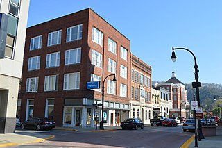
Pikeville is a city in and the county seat of Pike County, Kentucky, United States. During the 2010 U.S. Census, the population within Pikeville's city limits was 6,903. In Kentucky's current city classification system, Pikeville is a home rule-class city, a category that includes all of the state's more than 400 cities except for the two largest, Louisville and Lexington.

The Tug Fork is a tributary of the Big Sandy River, 159 miles (256 km) long, in southwestern West Virginia, southwestern Virginia, and eastern Kentucky in the United States. Via the Big Sandy and Ohio rivers, it is part of the watershed of the Mississippi River.

The Levisa Fork is a tributary of the Big Sandy River, approximately 164 miles (264 km) long, in southwestern Virginia and eastern Kentucky in the United States.

Mouthcard is a small unincorporated community in Pike County, Kentucky, United States near the Virginia state line. It lies on the Levisa Fork River of the Big Sandy River in the heart of the Appalachians. U.S. Route 460 runs through Mouthcard to meet U.S. Route 23 in Pikeville, the county seat.
Stone is an unincorporated community and coal town in Pike County, Kentucky, United States. It was established in 1912. Stone was a mining community named for Galen Stone, head of the Pond Creek Coal Company which was based in Stone. In 1922 the Pond Creek Coal Company was sold to Fordson Coal Company, which was a subsidiary of Ford Motor Company. In 1936 Fordson sold the mine at Stone to Eastern Coal Company.

New Milton is an unincorporated community in central Doddridge County, West Virginia, United States. The community is located along Meathouse Fork, southeast of the town of West Union, the county seat of Doddridge County. Its elevation is 833 feet (254 m). Although it is unincorporated, it has a post office, with the ZIP code of 26411.
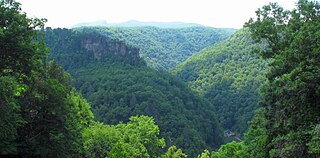
The Russell Fork is a 51.9-mile-long (83.5 km) tributary of the Levisa Fork in southwestern Virginia and southeastern Kentucky in the United States. Known for its whitewater, it rises in the Appalachian Mountains of southwest Virginia, in southern Dickenson County, and flows north through the town of Haysi, Virginia, the Breaks Interstate Park, and the town of Elkhorn City, Kentucky, in Pike County, where it flows into the Levisa Fork which, together with the Tug Fork, form the Big Sandy River.
Big Isaac is an unincorporated community in Doddridge County, West Virginia, United States. Big Isaac is 6 miles (9.7 km) south-southeast of Salem, along Laurel Run, a headwaters tributary of Meathouse Fork. The Big Isaac Post Office closed on December 31, 1962.
Blandville is an unincorporated community in Doddridge County, West Virginia, United States. Blandville is located along West Virginia Route 18 and Meathouse Fork 4.5 miles (7.2 km) southeast of West Union. Blandville had a post office, which closed on November 9, 2002.
Sugar Camp is an unincorporated community in Doddridge County, West Virginia, United States. The community is located along West Virginia Route 18 at the confluence of Toms Fork and Meathouse Fork.
Left Fork of Blackberry is an unincorporated community located in Pike County, Kentucky, United States.
Meathouse is an unincorporated community located in Pike County, Kentucky, United States.
Right Fork of Long Fork is an unincorporated community located in Pike County, Kentucky, United States.
Little Floyd County is an unincorporated community in Pike County, Kentucky, United States. Little Floyd County is located on Mare Creek 7.3 miles (11.7 km) northwest of Pikeville.
Upper Dick is an unincorporated community in Pike County, Kentucky. Upper Dick is located on Dix Fork 11.5 miles (18.5 km) northeast of Pikeville.
Meta is an unincorporated community in Pike County, Kentucky. Meta is located at the junction of Kentucky Route 1426 and Kentucky Route 2169 7.7 miles (12.4 km) northeast of Pikeville. The community had a post office from 1896 to 1959.
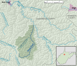
Toms Fork is a tributary of the Meathouse Fork, 9.3 miles (15.0 km) long, in north-central West Virginia in the United States. Via the Meathouse Fork, Middle Island Creek, and the Ohio River, it is part of the watershed of the Mississippi River, draining an area of 15.5 square miles (40 km2) in a rural region on the unglaciated portion of the Allegheny Plateau.


