Gedera, or less commonly known as Gdera (Hebrew: גְּדֵרָה), is a town in the southern part of the Shfela region in the Central District of Israel founded in 1884. It is 13 kilometres (8 miles) south of Rehovot.[3] In 2022, it had a population of 31,438.[1]
Tel Qatra, which lies at the northern edge of Gedera, is usually identified with Kedron, a place fortified by the Seleucids against the Hasmonaeans (1 Macc. 15:39–41, 16:9).[9] It has also been identified with Gedrus, a large village in the time of Eusebius (fourth century).[9] Eusebius identified Gedrus with biblical Gedor, which is a name also appearing on the Madaba map, but several other sites for Gedor have been proposed.[9]
Tel Qatra was occupied from the Middle Bronze Age to at least the early Islamic period.[9] Sometime between then and the Medieval period, the settlement moved to the southern foot of the tell, where the Palestinian village of Qatra existed until 1948.[9] Its peak was in the Byzantine period when the tell had at least one large public building.[9]
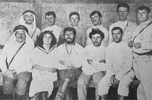
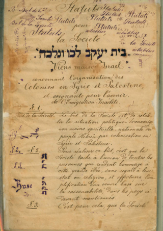
Gedera was founded in the winter of 1884 by members of the Bilu group, to the south of Qatra.[10] Gedera was established on a tract of village land purchased for the Biluites by Yechiel Michel Pines of the Lovers of Zion from the French consul in Jaffa, Poliovierre.[11][12] The first pioneers arrived at the site during the festival of Chanukah. In 1888, Benjamin and Mina Fuchs built Gedera's first stone house, later used as a Bnai Brith meeting house.[13]
The Zionist secular colonists of Gederah were young and considered aggressive towards the native Palestinian Arab population. Zionist sources indicate they provoked Palestinians in the adjacent village of Qatra, humiliating them and being unfair and arrogant towards them. In one case, following a quarrel with Qatra in 1887 (in the course of which a colonist was wounded while trying to prevent Arab herdsmen from grazing their flocks on the colony's land), the colonists deliberately started a fight to attract the attention of prominent Jewish activists in Jaffa.[14]
In 1912, a group of Yemenite immigrants settled in Gedera. During the British Mandate, Gedera became a popular resort due to its mild climate and fresh air.
Gedera 1930 1:20,000Gedera 1945 1:250,000
In 1949–1953, thousands of immigrants from Yemen, Romania, Iraq, Poland, Egypt, Morocco, Tunis, India, Iran, Libya, and other countries were housed in tent camps.[15]
Gedera water tower
The land on which Gederah was established had once been owned by the Palestinians of Qatra, who had lost it due to debts.[10] They were cultivating it as tenant farmers when the Jewish owners arrived and resented the intrusion onto what they still thought of as their land.[10] According to another account, the land was actually owned by Qatra, but had been assigned by the government to the nearby village of Mughar when Qatra disclaimed ownership to avoid a certain murder charge.[12] Mughar then sold it to Polivierre, who sold it to Pines.[12] This, and the proximity of the two sites, led to poor relations between the communities that sometimes led to violent clashes.[10]Israel Belkind, a member of Bilu, described Gedera's relationship with its Arab neighbors as among the worst in all the settlements.[10] Haim Hissin, also a Bilu member, criticized the Arabs for their provocative behavior, but also blamed the Jews for being unfair and arrogant.[10]
Qatra was depopulated by the Haganah on 17 May 1948.[16]
In the 1950s, a neighborhood called Oriel ("light of God") was established for new immigrants with visual impairments. The immigrants worked in a sheltered workshop, and the neighborhood was specially planned to promote their independence.[17]
On February 9, 2009, a Grad rocket fired from the Gaza Strip hit Gedera, marking the northernmost point in a round of 200 rockets targeting southern Israel.[18]
Gedera is built on seven hills in the Southern Coastal Plain which rise to the height of 80 metres (262 feet)above sea level. The town has an area of 14,500 dunams (14.5 square kilometres or 5.6 square miles).[19] Gedera is considered to be the southern edge of central Israel while Hadera is considered the northern edge, hence the Israeli expression "from Hadera to Gedera" to describe the most populated area in Israel.
At the time of the 1922 census of Palestine, Gedera had a population of 140 inhabitants, consisting of 136 Jews and 4 Christians.[21] The 1931 census, recorded 63 occupied houses and a population of 201 Jews and 7 Muslims.[22] By 1945, the population had increased to an estimated 970 Jews.[23]
Gedera today has a large population of Yemenite Jews. Most estimates put their population at 50% of Gedera, making it one of the few primarily Mizrahi towns in the Central District of Israel. In 2008, 1,700 Ethiopian Jews were living in Gedera.[24]
Economy
The principal agricultural branches of Gedera in its early years were grapes and grains. Citrus and other field crops were added later. In the 1930s, several industries were established, and the moshava became a vacation resort with convalescence and rest homes.[3]
Urban development
Gedera's position near the large south-central cities of Israel (Rehovot, Ashdod and Kiryat Gat), low prices for private homes and the fact that it is a green and quiet town yet it is in the central district near Tel Aviv and Jerusalem make it attractive to Israelis. Gedera is one of the faster-growing towns in Israel, with a 7.9% growth rate.[25]
New Gedera is an upscale neighborhood built by the Azorim company. A major shopping venue built by Azorim is the Gedera Mall, located in the southeast of the town. First opened in September 2007, Gedera Mall has small businesses along with anchor tenants from semi-major department stores from Israel and Europe.
The major road Highway 7 was recently constructed alongside the border of Gedera, linking Gedera directly to Israel's cross-country highway, Highway 6.
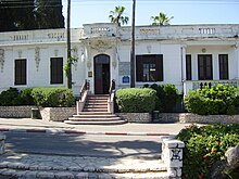
The Museum of the History of Gedera and the Biluim is located in a restored historical building at the end of Biluim Street.[26] Beit Mintz, built by Dr. Moshe Mintz, doubled as a residence (western wing) and communal hall (eastern side). When Mintz died in 1930, he bequeathed the house to the people of Gedera.[15] The house was used as a concert hall, a wedding venue and a move theater. In the summer, films were screened in the courtyard. In 1986, it was dedicated as a museum in the presence of the Mintz family.[27] A concrete monument entitled "Bereshit Bara" ("Genesis") by the Austrian artist Ernst Degasperi stands in a garden opposite the museum.[28]
The Sverdlov Hut is the one remaining hut built by the Biluim. It belonged to Chana and Yigal Sverdlov, who later left it to the city. A bell used to call residents for public meetings is located in the front yard. In 1885, the pioneers dug a 20×4×2 meter hole and covered it with a roof to use as a stable. Today, it has been restored, and is known as "Bor HaBilu'im".[15]
The first designated school building was built in 1896. Later, the building became "Beit HaIkar", the Farmer's House, a meeting place for the local farmers.[15]
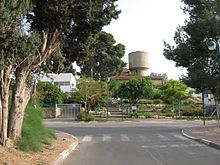
The 16.5 meter water tower behind Yeshurun Central Synagogue was built in 1935. The bottom floor was used as a classroom. The top floor held a water tank, and served as a watchtower.[15]
A sculpture garden in Gedera showcases the work of Yoma Segev, who creates sculptures from scrap and recycled materials.[29]
Archaeology
A pottery workshop for the manufacture of Gaza Jars was discovered at Tel Qatra, an archaeological tel on the outskirts of Gedera.[30] Gaza amphorae were used to ship wine and other foodstuffs across the Byzantine world.[31]
Ashkelon or Ashqelon is a coastal city in the Southern District of Israel on the Mediterranean coast, 50 kilometres (30 mi) south of Tel Aviv, and 13 kilometres (8 mi) north of the border with the Gaza Strip.
Gush Dan or Tel Aviv metropolitan area is a conurbation in Israel, located along the country's Mediterranean coastline. There is no single formal definition of Gush Dan, though the term is in frequent use by both governmental bodies and the general public. It ranges from combining Tel Aviv with cities that form an urban continuum with it, to the entire areas from both the Tel Aviv District and the Central District, or sometimes the whole Metropolitan Area of Tel Aviv, which includes a small part of the Southern District as well. Gush Dan is the largest conurbation and metropolitan area in Israel and the center of Israel's financial and High technology sector. The metropolitan area having an estimated population of 4,156,900 residents, 89% of whom are Israeli Jews.
Hadera is a city located in the Haifa District of Israel, in the northern Sharon region, approximately 45 kilometers (28 miles) from the major cities of Tel Aviv and Haifa. The city is located along 7 km (5 mi) of the Israeli Mediterranean Coastal Plain. The city's population includes a high proportion of immigrants arriving since 1990, notably from Ethiopia and the former Soviet Union. In 2022 it had a population of 103,041.
Lod, also known as Lydda, is a city 15 km southeast of Tel Aviv and 40 km (25 mi) northwest of Jerusalem in the Central District of Israel. It is situated between the lower Shephelah on the east and the coastal plain on the west. The city had a population of 85,351 in 2019.
Rehovot is a city in the Central District of Israel, about 20 kilometers south of Tel Aviv. In 2022 it had a population of 150,748.
Bilu was a Jewish movement of the late 19th century, fueled predominantly by the immigration of Russian Jews, whose goal was the agricultural settlement of the Land of Israel. Its members were known as Bilu'im, and the movement sought to inspire Jews to migrate to Ottoman Palestine. The Bilu'im rejected progressive notions such as Emancipation and assimilation as viable options for Jewish survival. The movement collapsed as a result of the challenging farming conditions in Palestine and a lack of funding to sustain the settlers.
The population of the region of Palestine, which approximately corresponds to modern Israel and the Palestinian territories, has varied in both size and ethnic composition throughout the history of Palestine.
Al-Shaykh Muwannis, also Sheikh Munis, was a small Palestinian Arab village in the Jaffa Subdistrict of Mandatory Palestine, located approximately 8.5 kilometers from the center of Jaffa city in territory earmarked for Jewish statehood under the UN Partition Plan. The village was abandoned in March 1948 due to the threats of Jewish militias, two months before the 1948 Arab–Israeli war. Today, Tel Aviv University lies on part of the village land.
The First Aliyah, also known as the agriculture Aliyah, was a major wave of Jewish immigration (aliyah) to Ottoman Palestine between 1881 and 1903. Jews who migrated in this wave came mostly from Eastern Europe and from Yemen, stimulated by pogroms and violence against the Jewish communities in those areas. An estimated 25,000 Jews immigrated. Many of the European Jewish immigrants during the late 19th-early 20th century period gave up after a few months and went back to their country of origin, often suffering from hunger and disease.
Qatra was a Palestinian Arab village in the Ramle Subdistrict, located 15 kilometers (9.3 mi) southwest of the city of Ramla and 40 kilometers (25 mi) west of Jerusalem, some 50 meters (160 ft) above sea level. It was depopulated in May 1948.
Salamah was a Palestinian Arab village, located five kilometers east of Jaffa, that was depopulated in the lead-up to the 1948 Arab-Israeli War. The town contains the supposed grave of Salama Abu Hashim, a companion of the Islamic prophet Muhammad. His tomb, two village schools, and ten houses from among the over 800 houses that had made up the village, are all that remain of the structures of the former village today.
Aseret is a community settlement on the coastal plain of south-central Israel. Located near Gedera, it falls under the jurisdiction of Gederot Regional Council.
Kidron is a moshav in central Israel. Located in the Shephelah just east of Gedera, and near the Tel Nof Airbase, it falls under the jurisdiction of Brenner Regional Council. In 2022 it had a population of 1,626.
Hulda is a kibbutz in central Israel. Located in the Shephelah near the Hulda Forest and the Burma Road, it falls under the jurisdiction of Gezer Regional Council. In 2022 it had a population of 1,187.
Following are timelines of the history of Ottoman Syria, taken as the parts of Ottoman Syria provinces under Ottoman rule.
Ghabat Kafr Sur was a Palestinian village in the Tulkarm Subdistrict of Mandatory Palestine. It was depopulated during the 1948 Arab–Israeli War on May 15, 1948, under Operation Coastal Clearing. It was located 16 km southwest of Tulkarm.
Israel Belkind was a Jewish educator, author, writer, historian and founder of the Bilu movement. A pioneer of the First Aliyah, Belkind founded the Biluim, a group of Jewish idealists aspiring to settle in the Land of Israel with the political purpose to redeem Eretz Yisrael and re-establish the Jewish State on it.
Mandatory Palestine was a geopolitical entity that existed between 1920 and 1948 in the region of Palestine under the terms of the League of Nations Mandate for Palestine.
Tel Erani or Tell esh-Sheikh Ahmed el-ʿAreini is a multi-period archaeological site on the outskirts of Kiryat Gat in the Southern District of Israel. It is also known by the name ʻIrâq el-Menshiyeh, although thought to have borne the original Arabic name of Menshiyet es-Saḥalīn. The tell was first occupied in the Chalcolithic period, but its most notable remains are from the Bronze Age and Iron Age, when it was the site of a substantial Philistine city with links to Egypt. It has been identified with the biblical cities of Libnah, Gath, Mmst, Eglon and Makkedah, but none of these identifications are certain. The city was destroyed in the 6th century BCE, possibly by the Babylonians. In the Persian period, it was the site of a temple. There are also signs of settlement in the Hellenistic, Byzantine, and Mamluk periods. The Palestinian village of Iraq al-Manshiyya was located at the foot of the tell until it was depopulated in the 1948 Arab–Israeli War.
↑ M. V. Guérin (1869). Description géographique, historique et archéologique de la Palestine. Vol.Judée II. Paris. p.35.{{cite book}}: CS1 maint: location missing publisher (link)
↑ W. F. Albright (1921–1922). "Contributions to the Historical Geography of Palestine". The Annual of the American School of Oriental Research in Jerusalem. 2/3: 1–46. doi:10.2307/3768450. JSTOR3768450.
↑ W. F. Albright (1922–1923). "Excavations and results at Tell El-Fûl (Gibeah Of Saul)". The Annual of the American Schools of Oriental Research. 4: iii–160. doi:10.2307/3768487. JSTOR3768487.
↑ Shmuel Vargon (1992). "Gedud: A Place-Name in the Shephelah of Judah". Vetus Testamentum. 42 (4): 557–564. doi:10.2307/1518965. JSTOR1518965.
1 2 3 4 5 6 Moshe Fischer; Itamar Taxel; David Amit (2008). "Rural settlement in the vicinity of Yavneh in the Byzantine period: A religio-archaeological perspective". Bulletin of the American Schools of Oriental Research (350): 7–35.
1 2 3 Arieh L. Avnieri (1984). The Claim of Dispossession; Jewish Land-Settlement and the Arabs, 1878–1948. New Brunswick and London: Transaction Books. p.90.
↑ Yuval Ben-Bassat (2009). "Proto-Zionist – Arab Encounters in Late Nineteenth-Century Palestine: Socioregional Dimensions". Journal of Palestine Studies. XXXVIII: 42–63.
↑ J. B. Barron, ed. (1923). Palestine: Report and General Abstracts of the Census of 1922. Government of Palestine. Table V. The alternative name Qatra Yehud also appears.
↑ E. Mills, ed. (1932). Census of Palestine 1931. Population of Villages, Towns and Administrative Areas. Jerusalem: Government of Palestine. p.3.
↑ Government of Palestine, Department of Statistics. Village Statistics, April, 1945. Quoted in S. Hadawi, Village Statistics, 1945. PLO Research Center, 1970, p66.
This page is based on this Wikipedia article Text is available under the CC BY-SA 4.0 license; additional terms may apply. Images, videos and audio are available under their respective licenses.