
Highway 6, also known as the Trans-Israel Highway or Cross-Israel Highway, is a major electronic toll highway in Israel. Highway 6 is the first Israeli Build-Operate-Transfer road constructed, carried out mainly by the private sector in return for a concession to collect tolls on the highway for a given number of years. It is also one of the largest infrastructure projects undertaken in Israel.

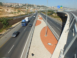
Highway 20, more commonly known as the Ayalon Highway, or simply Ayalon, is a major inter city freeway in Gush Dan, Israel. The road runs along the eastern border of central Tel Aviv from north to south and connects all of the major highways leading to the city—such as Highway 4 from Ashdod and the Southern regions, Highway 2 from Haifa and the Northern regions, Highway 5 from the East, and Highway 1 from Jerusalem and the Southeast. The Ayalon Highway is heavily used; on an average day, almost 600,000 vehicles enter the freeway. It consists of a multi-lane highway with a multi-track railway located between the opposite travel lanes. Some of the highway's route is along the Ayalon River, hence its name.

Highway 5 or the Trans-Samaria Highway, is one of Israel's main highways, connecting the Mediterranean coast immediately north of Tel Aviv with the central Sharon plain and eastwards to Ariel and other Israeli settlements in the northern West Bank.

Highway 2 is an Israeli highway located on the coastal plain of the Mediterranean Sea. It begins as a major arterial road within Tel Aviv, becoming a freeway as it exits the city northward, continuing to Haifa. North of Tel Aviv, the highway is also called The Coastal Highway.
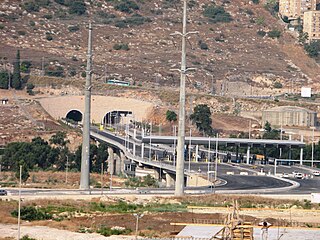
Highway 23, more-commonly known as the "Carmel Tunnels", are a set of toll tunnels in Haifa, Israel. The tunnels' purpose is to reduce road congestion in the Haifa area and to provide an alternate route for reaching the eastern and central parts of the city, Haifa Bay and the Krayot area to and from Israel's central coastal plain without having to travel through traffic-congested downtown Haifa, having to drive up and across Mount Carmel, or bypassing Haifa from the east – along the edge of the Jezreel Valley. The tunnels cut the travel time from the Haifa South interchange in the west to the Checkpost interchange in the east from 30–50 minutes down to 6 minutes.
Highway 22, also known as the Bay Highway, is a suburban freeway in the Haifa metropolitan area connecting downtown Haifa with the city's northern exit to the Krayot. From there it continues northwards as a bypass of the Krayot, providing an alternative route to Highway 4.
Highway 40 is a north-south intercity road in Israel. At 302 km long, it is the second longest highway in Israel, after Highway 90. The highway runs from Kfar Saba in the center of Israel to the Arabah in the south, serving as a main connection between central Israel and Be'er Sheva.

Highway 3 is a highway in Israel. It begins at Highway 4 on the outskirts of Ashkelon, running east-northeast, passing through Kiryat Malakhi and Latrun, and ending just short of Modi'in.

Highway 12 is a single carriageway road in the South District of Israel. It surrounds the mountains of Eilat from the north and west, and it connects Eilat to Highway 10 and Highway 40, which lead toward central Israel. Highway 10 continues north toward the Gaza Strip, whereas Highway 40 proceeds to Beersheba via Mizpe Ramon.

Highway 13 is an expressway in southern Israel. It is 12 km long. It begins in the north at Tzihor junction with Highway 40 and ends in the south at Menuha junction with Highway 90. Thus, it connects between Highway 40, which runs north to Mizpe Ramon and Beersheba via the central Negev, and Highway 90, which traverses the Arava region on Israel's eastern border.

Highway 25 is a rural highway in southern Israel. It begins northwest of Nahal Oz at the border with the Gaza Strip, and it passes through Netivot, Beersheba and Dimona. It continues southeast toward Arava Junction, where it meets Highway 90. Its length is estimated by the Israeli Department of Transportation as 172 km and 780 meters.
Highway 34 is a highway in the South District of Israel that begins at Yad Mordechai in the north, passes through Sderot, and ends in the south at Netivot. Its length is 19.75 km.
Highway 41 is an arterial road in south-central Israel. It connects Highway 4 and Highway 7 to the Port of Ashdod. The designation "41" also applied to the continuation of the road eastward to Gedera until that section of the road was upgraded and renamed "7".
Highway 42 is a north-south highway in central Israel. It leads from just south of Ashdod Interchange in the south to Gan Rave interchange in the north. The road is 19 km (12 mi) long.

Highway 46 is a short highway in central Israel. The road, just 4 km long, was created to bypass the portion of Highway 40 that crosses the aviation industrial zone near Ben Gurion International Airport, a section of road that suffers from heavy traffic.
Highway 9 is an east-west limited-access expressway in Israel that opened to traffic on July 24, 2014.

Highway 71 is an east-west highway that passes through the eastern Jezreel Valley and the Beit She'an Valley, below the north slopes of the Gilboa mountains, in northern Israel. The road follows a path parallel to the Harod Creek in the Harod Valley and to the Jezreel Valley railway. It is 35 kilometres (22 mi) long and leads from Afula in the west, via Beit She'an, to the Jordan River Border Crossing in the east. The Navot interchange located approximately 10 km southeast of Afula provides a shortcut via Route 675 through the Ta'anakh region from Highway 71 and Beit She'an to Highway 65 and central Israel.
Highway 77 is an east-west highway in northern Israel. It crosses the Lower Galilee in the region of the Beit Netofa Valley. The road leads from the Tel Qashish Interchange nearby Yokneam Illit to Tiberias. It is 48km long. Its western section, from the Tel Qashish Interchange to the Golani Interchange is a freeway.

Route 531, is a suburban freeway in the southern Sharon region of Israel, just north of the Tel Aviv Metropolitan Area. The highway begins at Highway 6 and terminates at the Ayalon Highway with an extension to the Coastal Highway.

Highway 45 is the official designation of a 3.3 km stretch of road forming a continuous connection between Route 443 from the Tel Aviv Metropolitan Area and Highway 50 to central Jerusalem and a 1.4 km spur serving the Atarot Industrial Park.

