Light Rail
Red Line | ||||||||||||||||||||||||||||||||||||||||||||||||||||||||||||||||||||||||||||||||||||||||||||||||||||||||||||||||||||||||||||||||||||||||||||||||||||||||||||||||||||||||||||||||||||||||||||||||||||||||||||||||||||||||||||||||||||||||||||||||||||||||||||
|---|---|---|---|---|---|---|---|---|---|---|---|---|---|---|---|---|---|---|---|---|---|---|---|---|---|---|---|---|---|---|---|---|---|---|---|---|---|---|---|---|---|---|---|---|---|---|---|---|---|---|---|---|---|---|---|---|---|---|---|---|---|---|---|---|---|---|---|---|---|---|---|---|---|---|---|---|---|---|---|---|---|---|---|---|---|---|---|---|---|---|---|---|---|---|---|---|---|---|---|---|---|---|---|---|---|---|---|---|---|---|---|---|---|---|---|---|---|---|---|---|---|---|---|---|---|---|---|---|---|---|---|---|---|---|---|---|---|---|---|---|---|---|---|---|---|---|---|---|---|---|---|---|---|---|---|---|---|---|---|---|---|---|---|---|---|---|---|---|---|---|---|---|---|---|---|---|---|---|---|---|---|---|---|---|---|---|---|---|---|---|---|---|---|---|---|---|---|---|---|---|---|---|---|---|---|---|---|---|---|---|---|---|---|---|---|---|---|---|---|---|---|---|---|---|---|---|---|---|---|---|---|---|---|---|---|---|---|---|---|---|---|---|---|---|---|---|---|---|---|---|---|---|
| ||||||||||||||||||||||||||||||||||||||||||||||||||||||||||||||||||||||||||||||||||||||||||||||||||||||||||||||||||||||||||||||||||||||||||||||||||||||||||||||||||||||||||||||||||||||||||||||||||||||||||||||||||||||||||||||||||||||||||||||||||||||||||||
The Tel Aviv Light Rail Red Line will pass through Bnei Brak as an underground light rail system, expected to be operational in 2022. It is planned to be built underground as it passes through the city.
Transport in Bnei Brak occupies a central location within the Gush Dan (Israel's main metropolitan centre). It has an important role in transport throughout the region.
Across the Gush Dan, metropolitan local bus services are operated by the Dan Bus Company. Many buses traverse Bnei Brak due to its central location, East of Tel Aviv, west of Petah Tikva, north of Ramat Gan, and south of Ramat HaSharon
Red Line | ||||||||||||||||||||||||||||||||||||||||||||||||||||||||||||||||||||||||||||||||||||||||||||||||||||||||||||||||||||||||||||||||||||||||||||||||||||||||||||||||||||||||||||||||||||||||||||||||||||||||||||||||||||||||||||||||||||||||||||||||||||||||||||
|---|---|---|---|---|---|---|---|---|---|---|---|---|---|---|---|---|---|---|---|---|---|---|---|---|---|---|---|---|---|---|---|---|---|---|---|---|---|---|---|---|---|---|---|---|---|---|---|---|---|---|---|---|---|---|---|---|---|---|---|---|---|---|---|---|---|---|---|---|---|---|---|---|---|---|---|---|---|---|---|---|---|---|---|---|---|---|---|---|---|---|---|---|---|---|---|---|---|---|---|---|---|---|---|---|---|---|---|---|---|---|---|---|---|---|---|---|---|---|---|---|---|---|---|---|---|---|---|---|---|---|---|---|---|---|---|---|---|---|---|---|---|---|---|---|---|---|---|---|---|---|---|---|---|---|---|---|---|---|---|---|---|---|---|---|---|---|---|---|---|---|---|---|---|---|---|---|---|---|---|---|---|---|---|---|---|---|---|---|---|---|---|---|---|---|---|---|---|---|---|---|---|---|---|---|---|---|---|---|---|---|---|---|---|---|---|---|---|---|---|---|---|---|---|---|---|---|---|---|---|---|---|---|---|---|---|---|---|---|---|---|---|---|---|---|---|---|---|---|---|---|---|---|
| ||||||||||||||||||||||||||||||||||||||||||||||||||||||||||||||||||||||||||||||||||||||||||||||||||||||||||||||||||||||||||||||||||||||||||||||||||||||||||||||||||||||||||||||||||||||||||||||||||||||||||||||||||||||||||||||||||||||||||||||||||||||||||||
The Tel Aviv Light Rail Red Line will pass through Bnei Brak as an underground light rail system, expected to be operational in 2022. It is planned to be built underground as it passes through the city.
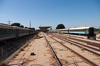
The Bnei Brak Railway Station opened in 1949 but was closed during the 1990s for refurbishment. It was reopened, and rebuilt in 2000. The station is, however, a fair distance from the city centre and so less accessible. The station is served by trains on the suburban Kfar Saba to Rishon LeZion line.
Bnei Brak's eastern border is demarcated by Highway 4, to the west the city is easily accessible from the Ayalon Highway.

Tel Aviv-Yafo, often referred to as just Tel Aviv, is the most populous city in the Gush Dan metropolitan area of Israel. Located on the Israeli Mediterranean coastline and with a population of 460,613, it is the economic and technological center of the country. If East Jerusalem is considered part of Israel, Tel Aviv is the country's second most populous city after Jerusalem; if not, Tel Aviv is the most populous city ahead of West Jerusalem.

Transportation in Israel is based mainly on private motor vehicles and bus service and an expanding railway network. A lack of inland waterways and the small size of the country make air and water transport of only minor importance in domestic transportation, but they are vitally important for Israel's international transport links. Demands of population growth, political factors, the Israel Defense Forces, tourism and increased traffic set the pace for all sectors, being a major driver in the mobility transition towards railways and public transit while moving away from motorized road transport. All facets of transportation in Israel are under the supervision of the Ministry of Transport and Road Safety.

Gush Dan is a conurbation in Israel, located along the country's Mediterranean coastline. There is no single formal definition of Gush Dan, though the term is in frequent use by governmental bodies. It ranges from combining Tel Aviv with cities that form urban continuum with it, to the entire areas from both the Tel Aviv and the Central District, or sometimes the whole Metropolitan Area of Tel Aviv., which includes a small part of the Southern District as well. Gush Dan is the largest conurbation and metropolitan area in Israel, with the metropolitan area having an estimated population of 4,054,570 residents, 95% of whom are Israeli Jews.
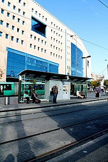
The Jerusalem Central Bus Station is the main bus depot in Jerusalem, Israel and one of the busiest bus stations in the country. Located on Jaffa Road near the entrance to the city, it serves Egged, Superbus and Dan intercity bus routes. City buses and light rail trains pick up and discharge passengers across the street on Jaffa Road and on Zalman Shazar Boulevard, which can be accessed via an underground pedestrian passageway. The entrance to Israel Railways' underground Navon Railway Station is located across the light rail stop in front of the station.
Dankal is a planned mass transit system for the Tel Aviv metropolitan area in central Israel. The system will include different modes of mass transit, including rapid transit (metro), light rail transit (LRT), and bus rapid transit (BRT). Overseen by the government agency NTA, the project will complement the intercity and suburban rail network operated by Israel Railways.

Highway 20, more commonly known as the Ayalon Highway, or simply Ayalon, is a major intracity freeway in Gush Dan, Israel. The road runs along the eastern border of central Tel Aviv from north to south and connects all of the major highways leading to the city—such as Highway 4 from Ashdod and the Southern regions, Highway 2 from Haifa and the Northern regions, Highway 5 from the East, and Highway 1 from Jerusalem and the Southeast. The Ayalon Highway is heavily used; on an average day almost 600,000 vehicles enter the freeway. It consists of a multi-lane highway with a multi-track railway located between the opposite travel lanes. Some of the highway's route is along the Ayalon River, hence its name.
This article is about transport in Petah Tikva, Israel.

Tel Aviv University railway station is an Israel Railways station in northern Tel Aviv, Israel. It is officially named Tel Aviv Universita – Merkaz HaYeridim in Hebrew, due to its proximity to Tel Aviv University and Expo Tel Aviv.

The Tel Aviv Savidor Central railway station is a major railway station on the Ayalon Railway in central Tel Aviv, Israel, serving most lines of Israel Railways.

Transport in Jerusalem is characterized by a well-developed inter-city network and an emerging, developing intra-city network. Ben Gurion International Airport serves as Jerusalem's closest international airport. Egged bus lines and Israel Railways connect the city of Jerusalem to much of Israel, and a high-speed rail line to the airport and Tel Aviv is currently under construction, while the segment to Ben Gurion Airport is already in limited operation. Within the city, the roads, rather than the rails, are the primary mode of transportation.

Rail transport in Israel includes heavy rail as well as light rail. Excluding light rail, the network consists of 1,384 kilometers (860 mi) of track, and is undergoing constant expansion. All of the lines are standard gauge and as of 2016 the heavy rail network is in the initial stages of an electrification program. A government owned company, Israel Railways, manages the entire heavy rail network. Most of the network is located on the densely populated coastal plain. Some of the rail routes in Israel date back to before the establishment of the state – to the days of the British Mandate for Palestine and earlier. Rail infrastructure was considered less important than road infrastructure during the state's early years, and except for the construction of the coastal railway in the early 1950s, the network saw little investment until the late 1980s. In 1993, a rail connection was opened between the coastal railway from the north and southern lines through Tel Aviv. Previously the only connection between northern railways and southern railways bypassed the Tel Aviv region – Israel's population and commercial center. The linking of the nationwide rail network through the heart of Tel Aviv was a major factor in facilitating further expansion in the overall network during the 1990s and 2000s and as a result of the heavy infrastructure investments passenger traffic rose significantly, from about 2.5 million per year in 1990 to about 67 million in 2018.

The Tel Aviv transportation system is seen as the hub of the Israeli transport network in terms of road, rail, and air transport. The Israeli road network partly centers on the city, with some of the country's largest highways passing through or running to the city. The city forms a major part of the country's rail network, whilst Ben Gurion International Airport located near the city is the country's largest airport. There is also a strong public transport system within the city, based primarily on bus transportation.

Bnei Brak–Ramat HaHayal railway station is a suburban passenger railway station in Israel, operated by Israel Railways. It is located on the Yarkon Railway near the Bnei Brak–Ramat Gan and Bnei Brak–Tel Aviv borders next to the Ayalon Mall and Ramat Gan Stadium. In spite of its proximity to important industrial and commercial areas of Gush Dan as well as to residential areas of Tel Aviv, Bnei Brak is one of the less-popular stations of Israel Railways, possibly because of its misleading name and lack of awareness. As a result, in an effort to increase the public's awareness of the station, the name of the Ramat HaHayal neighborhood located to the north of the station was added to the station's name in 2016.

Herzliya railway station is an Israel Railways passenger station located in the city of Herzliya. The station currently has three island platforms serving two tracks each. In the 2010s, the Ayalon Highway was extended past the station northwards so that the platforms lie contained in the median of the highway, like the train stations in Tel Aviv.
The Red Line will be the first section of a light rail system in the Tel Aviv metropolitan area, known as the Tel Aviv Light Rail. The line will run from Bat Yam in the south to Petah Tikva in the northeast with a significant portion of it underground. The total cost of the red line is estimated at NIS 11 billion or, approximately US$3 billion. Construction began in 2011 and is expected to be completed in February 2023, after numerous delays.
Tel Aviv South railway station was the name of two former railway stations in Tel Aviv, Israel, which were situated in two different locations. The original station opened in 1920, then in 1970 it was relocated 2.5 km south-east, and it finally closed to passengers in 1993.
The Israeli city of Beersheba occupies a central role in southern Israel. Because of its central position in the Negev it is situated on important national routes reaching down to the far southern port of Eilat. Be'er Sheva is also home to a population of 195,000, with an estimated metro population at over 500,000 making it one of the largest cities in Israel. Much of the cities high-tech industry is concentrated in the center of the city, with Industrial estates existing in the south of the city, both of these areas are thus extensively served.

The Rishon LeZion Moshe Dayan railway station is an Israel Railways station in Rishon LeZion. The station is located adjacent to the Moshe Dayan Interchange on the Ayalon Highway. It serves as the terminus of a new suburban passenger line serving the cities of Holon, Bat Yam, and Rishon LeZion in southern Gush Dan. Current travel time from the station to Tel Aviv HaHagana railway station is about 18 minutes.
The Yarkon Railway is a double-track railroad following the course of the Yarkon River in the central area of Israel. It is about 15 km long, stretching from the Coastal Railway to the Eastern Railway.
The Purple Line is a light rail transit (LRT) line under construction in the Tel Aviv metropolitan Area in Israel. The line will operate as part of the planned Tel Aviv metropolitan area mass transit system and is expected to be the second line to open. The line will connect the city centre of Tel Aviv with its eastern suburbs of Yehud and Giv'at Shmuel.
| |
| Commuter rail | |
| Metro |
|
| Light rail | |
| Bus rapid transit | |
| Funicular | |
| Cable car | |
Italics: under construction or currently not operational | |
| Roads |
| ||||
|---|---|---|---|---|---|
| Bus operators | |||||
| Rail transport |
| ||||
| Cycle infrastructure | |||||
| Sea ports | |||||
| Aviation |
| ||||
| Cable cars | |||||
| By city | |||||
| Smart cards | |||||