Route 293 is a rural road that connects Highway 40 to Netivot and to Route 34 and Highway 25. Many Kibbutzim and Moshavim are along its path.

Route 293 is a rural road that connects Highway 40 to Netivot and to Route 34 and Highway 25. Many Kibbutzim and Moshavim are along its path.
This article contains a bulleted list or table of intersections which should be presented in a properly formatted junction table.(November 2021) |
| Junction | Location | Intersecting roads |
|---|---|---|
| Beit Kama Junction | Beit Kama | Highway 40 |
| Sde Tzvi Junction | Sde Tzvi | Route 334 |
| HaGdi Junction | Netivot | Highway 25 |
| Roads |
| ||||
|---|---|---|---|---|---|
| Bus operators | |||||
| Rail transport |
| ||||
| Cycling | |||||
| Sea ports | |||||
| Aviation |
| ||||
| Cable cars | |||||
| By city | |||||
| Smart cards | |||||

The Dwight D. Eisenhower National System of Interstate and Defense Highways, commonly known as the Interstate Highway System, is a network of controlled-access highways that forms part of the National Highway System in the United States. The system extends throughout the contiguous United States and has routes in Hawaii, Alaska, and Puerto Rico.

The United States Numbered Highway System is an integrated network of roads and highways numbered within a nationwide grid in the contiguous United States. As the designation and numbering of these highways were coordinated among the states, they are sometimes called Federal Highways, but the roadways were built and have always been maintained by state or local governments since their initial designation in 1926.

The Trans-Canada Highway is a transcontinental federal–provincial highway system that travels through all ten provinces of Canada, from the Pacific Ocean on the west coast to the Atlantic Ocean on the east coast. The main route spans 7,476 km (4,645 mi) across the country, one of the longest routes of its type in the world. The highway system is recognizable by its distinctive white-on-green maple leaf route markers, although there are small variations in the markers in some provinces.

U.S. Route 1 or U.S. Highway 1 (US 1) is a major north–south United States Numbered Highway that serves the East Coast of the United States. It runs 2,370 miles (3,810 km) from Key West, Florida, north to Fort Kent, Maine, at the Canadian border, making it the longest north–south road in the US. US 1 is generally paralleled by Interstate 95 (I-95), though US 1 is significantly farther west (inland) between Jacksonville, Florida, and Petersburg, Virginia, while I-95 is closer to the coastline. In contrast, US 1 in Maine is much closer to the coast than I-95, which runs farther inland than US 1. The route connects most of the major cities of the East Coast—including Miami, Jacksonville, Raleigh, Richmond, Washington DC, Baltimore, Philadelphia, New York City, and Boston passing from the Southeastern US to New England.

State Route 1 (SR 1) is a major north–south state highway that runs along most of the Pacific coastline of the U.S. state of California. At 656 miles (1,056 km), it is the longest state route in California, and the second-longest in the US after Montana Highway 200. SR 1 has several portions designated as either Pacific Coast Highway (PCH), Cabrillo Highway, Shoreline Highway, or Coast Highway. Its southern terminus is at Interstate 5 (I-5) near Dana Point in Orange County and its northern terminus is at U.S. Route 101 (US 101) near Leggett in Mendocino County. SR 1 also at times runs concurrently with US 101, most notably through a 54-mile (87 km) stretch in Ventura and Santa Barbara counties, and across the Golden Gate Bridge.

U.S. Route 66 or U.S. Highway 66 was one of the original highways in the United States Numbered Highway System. It was established on November 11, 1926, with road signs erected the following year. The highway, which became one of the most famous roads in the United States, originally ran from Chicago, Illinois, through Missouri, Kansas, Oklahoma, Texas, New Mexico, and Arizona before terminating in Santa Monica in Los Angeles County, California, covering a total of 2,448 miles (3,940 km).

The Lincoln Highway is the first transcontinental highway in the United States and one of the first highways designed expressly for automobiles. Conceived in 1912 by Indiana entrepreneur Carl G. Fisher, and formally dedicated October 31, 1913, the Lincoln Highway runs coast-to-coast from Times Square in New York City west to Lincoln Park in San Francisco, originally through 13 states: New York, New Jersey, Pennsylvania, Ohio, Indiana, Illinois, Iowa, Nebraska, Colorado, Wyoming, Utah, Nevada, and California. In 1915, the "Colorado Loop" was removed, and in 1928, a realignment relocated the Lincoln Highway through the northern tip of West Virginia. Thus, there are a total of 14 states, 128 counties, and more than 700 cities, towns and villages through which the highway passed at some time in its history.

The Pan-American Highway is a network of roads stretching across the Americas and measuring about 30,000 kilometres (19,000 mi) in total length. Except for a break of approximately 106 km (66 mi) across the border between northwest Colombia and southeast Panama called the Darién Gap, the roads link almost all of the Pacific coastal countries of the Americas in a connected highway system. According to Guinness World Records, the Pan-American Highway is the world's longest "motorable road". It is only possible to cross by land between South America and Central America—the last town in Colombia to the first outpost in Panama—by a difficult and dangerous hike of at least four days through the Darién Gap, one of the rainiest areas of the planet.
A state highway, state road, or state route is usually a road that is either numbered or maintained by a sub-national state or province. A road numbered by a state or province falls below numbered national highways in the hierarchy. Roads maintained by a state or province include both nationally numbered highways and un-numbered state highways. Depending on the state, "state highway" may be used for one meaning and "state road" or "state route" for the other.

Numbered highways in Canada are split by province, and a majority are maintained by their province or territory transportation department. All highways in Canada are numbered except for three in the Northwest Territories, one in Alberta, one in Ontario, and one in Quebec. Ontario's 7000 series are not marked with their highway number but have been assigned one by the Ministry of Transportation. A number of highways in all provinces are better known locally by their name rather than their number. Some highways have additional letters added to their number: A is typically an alternate route, B is typically a business route, and other letters are used for bypass (truck) routes, connector routes, scenic routes, and spur routes. The territory of Nunavut has no highways.

Highways in Australia are generally high capacity roads managed by state and territory government agencies, though Australia's federal government contributes funding for important links between capital cities and major regional centres. Prior to European settlement, the earliest needs for trade and travel were met by narrow bush tracks, used by tribes of Indigenous Australians. The formal construction of roads began in 1788, after the founding of the colony of New South Wales, and a network of three major roads across the colony emerged by the 1820s. Similar road networks were established in the other colonies of Australia. Road construction programs in the early 19th century were generally underfunded, as they were dependent on government budgets, loans, and tolls; while there was a huge increase in road usage, due to the Australian gold rushes. Local government authorities, often known as Road Boards, were therefore established to be primarily responsible for funding and undertaking road construction and maintenance. The early 1900s saw both the increasingly widespread use of motorised transportation, and the creation of state road authorities in each state, between 1913 and 1926. These authorities managed each state's road network, with the main arterial roads controlled and maintained by the state, and other roads remaining the responsibility of local governments. The federal government became involved in road funding in the 1920s, distributing funding to the states. The depression of the 1930s slowed the funding and development of the major road network until the onset on World War II. Supply roads leading to the north of the country were considered vital, resulting in the construction of Barkly, Stuart, and Eyre Highways.

U.S. Route 40 or U.S. Highway 40 (US 40), also known as the Main Street of America, is a major east–west United States Highway traveling across the United States from the Mountain States to the Mid-Atlantic States. As with most routes whose numbers end in a zero, US 40 once traversed the entire United States. It is one of the first U.S. Highways created in 1926 and its original termini were in San Francisco, California, and Atlantic City, New Jersey. US 40 currently ends at a junction with I-80 in Silver Summit, Utah, just outside Salt Lake City. West of this point US 40 was functionally replaced with I-80, and as these segments of I-80 were constructed the western portion of US 40 was truncated several times.
A routenumber, designation or abbreviation is an identifying numeric designation assigned by a highway authority to a particular stretch of roadway to distinguish it from other routes and, in many cases, also to indicate its classification, general geographical location and/or orientation. The numbers chosen may be used solely for internal administrative purposes; however, in most cases they are also displayed on roadside signage and indicated on maps.

A concurrency in a road network is an instance of one physical roadway bearing two or more different route numbers. When two roadways share the same right-of-way, it is sometimes called a common section or commons. Other terminology for a concurrency includes overlap, coincidence, duplex, triplex, multiplex, dual routing or triple routing.
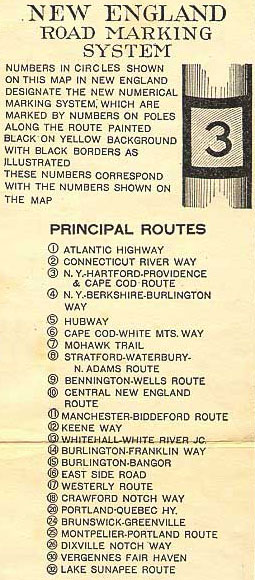
The New England road marking system was a regional system of marked numbered routes in the six-state region of New England in the United States. The routes were marked by a yellow rectangular sign with black numbers and border. Many signs were painted on telephone poles. The routes were approved by the highway departments of the six New England states in April 1922.

A supplemental route is a state secondary road in the U.S. state of Missouri, designated with letters. Supplemental routes were various roads within the state which the Missouri Department of Transportation was given in 1952 to maintain in addition to the regular routes, though lettered routes had been in use from at least 1932. The four types of roads designated as Routes are: