
Highway 5 or the Trans-Samaria Highway, is one of Israel's main highways, connecting the Mediterranean coast immediately north of Tel Aviv with the central Sharon plain and eastwards to Ariel and other Israeli settlements in the northern West Bank.

Highway 3 is a highway in Israel. It begins at Highway 4 on the outskirts of Ashkelon, running east-northeast, passing through Kiryat Malakhi and Latrun, and ending just short of Modi'in.
Highway 7 is a highway in the South District of Israel from Ashdod to Yad Binyamin. It connects the Port of Ashdod with the Trans-Israel Highway.

Highway 10 is a road in the South District of Israel. It is one of the longest routes in Israel, extending for nearly the entire border of Israel with Egypt from the Gaza Strip in the north to Sayarim junction in the south. Under a military security advisory, its entire 113-mile length is almost permanently off-limits to civilian traffic.

Highway 13 is an expressway in southern Israel. It is 12 km long. It begins in the north at Tzihor junction with Highway 40 and ends in the south at Menuha junction with Highway 90. Thus, it connects between Highway 40, which runs north to Mizpe Ramon and Beersheba via the central Negev, and Highway 90, which traverses the Arava region on Israel's eastern border.

Highway 25 is a rural highway in southern Israel. It begins northwest of Nahal Oz at the border with the Gaza Strip, and it passes through Netivot, Beersheba and Dimona. It continues southeast toward Arava Junction, where it meets Highway 90. Its length is estimated by the Israeli Department of Transportation as 172 km and 780 meters.
Highway 31 is an inter-city highway in southern Israel. It begins at Lakiya Interchange with Highway 6 at Lakiya. It passes through Hura, Kuseife, Arad, and it terminates at Zohar Junction with Highway 90 south of Neve Zohar just west of the Dead Sea.
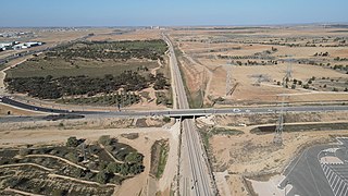
Highway 34 is a highway in the South District of Israel that begins at Yad Mordechai in the north, passes through Sderot, and ends in the south at Netivot. Its length is 19.75 km.

Highway 38 is an arterial road in the low plains of Judea in Israel. It serves as the main access route to Beit Shemesh and as a main north–south route in the region. Along the route are many nature preserves and archeological sites.
Highway 41 is an arterial road in south-central Israel. It connects Highway 4 and Highway 7 to the Port of Ashdod. The designation "41" also applied to the continuation of the road eastward to Gedera until that section of the road was upgraded and renamed "7".
Highway 42 is a north-south highway in central Israel. It leads from just south of Ashdod Interchange in the south to Gan Rave interchange in the north. The road is 19 km (12 mi) long.

Highway 46 is a short highway in central Israel. The road, just 4 km long, was created to bypass the portion of Highway 40 that crosses the aviation industrial zone near Ben Gurion International Airport, a section of road that suffers from heavy traffic.

Highway 71 is an east-west highway that passes through the eastern Jezreel Valley and the Beit She'an Valley, below the north slopes of the Gilboa mountains, in northern Israel. The road follows a path parallel to the Harod Creek in the Harod Valley and to the Jezreel Valley railway. It is 35 kilometres (22 mi) long and leads from Afula in the west, via Beit She'an, to the Jordan River Border Crossing in the east. The Navot interchange located approximately 10 km southeast of Afula provides a shortcut via Route 675 through the Ta'anakh region from Highway 71 and Beit She'an to Highway 65 and central Israel.

Highway 70 is a highway, 44 km in length, running through the Western Galilee region in the Northern District of Israel. It connects the Lower Galilee to Kiryat Ata and Shlomi near Israel's border with Lebanon.
Route 264 is a north-south regional highway in southern Israel. It connects Highway 25 at HaNasi junction with Highway 40 at Kama junction. It is 14.5km long.

Route 171 is a regional east-west road in southern Israel. It is the only east-west road in the Negev Mountains. It is 33 km long. It goes from Mount Harif junction on Highway 10 adjacent to Israel's border with Egypt to HaRuhot junction with Highway 40 about 5 km north of Mitzpe Ramon. The road passes mostly along the northern edge of Makhtesh Ramon and along the flowing path of Nahal Nitzana. In its eastern portion, it crosses HaRuhot Plain and passes by the Mitzpe Ramon Airport.

Route 864 is a north-south regional highway in the Galilee in northern Israel. It begins in the south at Rameh junction with Highway 85 and ends in the north at Hosen junction with Highway 89.

Route 386 is a road in Israel that runs from Tzur Hadassah to Jerusalem.

Highway 45 is the official designation of a 3.3 km stretch of road forming a continuous connection between Route 443 from the Tel Aviv Metropolitan Area and Highway 50 to central Jerusalem and a 1.4 km spur serving the Atarot Industrial Park.

Route 227 is a 34-kilometre (21 mi) road in the eastern Negev desert of Israel. It starts from an intersection with Route 206 in the northwest and ends in Ir Ovot in the southeast, intersecting with Highway 90. It has one at-grade intersection at 19 km. The original road was laid by British land surveyors in 1927. Prior to 1956, this was the primary route from Beersheba to Eilat.


