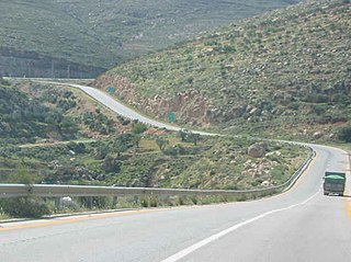
Allon Road is the name given by Israel to Routes 458, 508, and 578 in the West Bank, running roughly south–north along the eastern watershed of the Judaean and Samarian Hills, between Highway 1 near Kfar Adumim east of Jerusalem and Highway 90 at Mehola in the central Jordan Valley.

Highway 3 is a highway in Israel. It begins at Highway 4 on the outskirts of Ashkelon, running east-northeast, passing through Kiryat Malakhi and Latrun, and ending just short of Modi'in.
Highway 7 is a highway in the South District of Israel from Ashdod to Yad Binyamin. It connects the Port of Ashdod with the Trans-Israel Highway.

Highway 10 is a road in the South District of Israel. It is one of the longest routes in Israel, extending for nearly the entire border of Israel with Egypt from the Gaza Strip in the north to Sayarim junction in the south. Under a military security advisory, its entire 113-mile length is almost permanently off-limits to civilian traffic.

Highway 12 is a single carriageway road in the South District of Israel. It surrounds the mountains of Eilat from the north and west, and it connects Eilat to Highway 10 and Highway 40, which lead toward central Israel. Highway 10 continues north toward the Gaza Strip, whereas Highway 40 proceeds to Beersheba via Mizpe Ramon.

Highway 25 is a rural highway in southern Israel. It begins northwest of Nahal Oz at the border with the Gaza Strip, and it passes through Netivot, Beersheba and Dimona. It continues southeast toward Arava Junction, where it meets Highway 90. Its length is estimated by the Israeli Department of Transportation as 172 km and 780 meters.
Route 293 is a rural road that connects Highway 40 to Netivot and to Route 34 and Highway 25. Many Kibbutzim and Moshavim are along its path.

Highway 92 is a north-south highway in northeastern Israel. It follows the eastern edge of the Kinneret from Ma'agan junction in the south at Highway 98 to Yehudiya junction in the north at Highway 87. It is 26.15 km long.

Highway 91 is an east-west highway in northern Israel and the Golan Heights. It extends through the Jordan Rift Valley and the central Golan Heights. It begins in the west at Mahanayim junction with Highway 90, and it ends in the east at Zivan junction near the Israeli settlement Ein Zivan, where it meets Highway 98. The road is 28 km long.
Highway 42 is a north-south highway in central Israel. It leads from just south of Ashdod Interchange in the south to Gan Rave interchange in the north. The road is 19 km (12 mi) long.

Highway 46 is a short highway in central Israel. The road, just 4 km long, was created to bypass the portion of Highway 40 that crosses the aviation industrial zone near Ben Gurion International Airport, a section of road that suffers from heavy traffic.
Highway 9 is an east-west limited-access expressway in Israel that opened to traffic on July 24, 2014.

Highway 66 is a north–south highway in the Jezreel Valley in northern Israel.
Highway 77 is an east-west highway in northern Israel. It crosses the Lower Galilee in the region of the Beit Netofa Valley. The road leads from the Tel Qashish Interchange nearby Yokneam Illit to Tiberias. It is 48km long. Its western section, from the Tel Qashish Interchange to the Golani Interchange is a freeway.

Route 171 is a regional east-west road in southern Israel. It is the only east-west road in the Negev Mountains. It is 33 km long. It goes from Mount Harif junction on Highway 10 adjacent to Israel's border with Egypt to HaRuhot junction with Highway 40 about 5 km north of Mitzpe Ramon. The road passes mostly along the northern edge of Makhtesh Ramon and along the flowing path of Nahal Nitzana. In its eastern portion, it crosses HaRuhot Plain and passes by the Mitzpe Ramon Airport.

Route 999 is an east–west regional route in the northern Golan Heights, which Israel captured from Syria in the Six-Day War in 1967. Its access is restricted to Israeli army vehicles for almost its entire length. It begins from Si'on adjacent to the community Snir and the village Ghajar, where it splits north from Highway 99. About 2 km after this junction stands an IDF checkpoint. After the checkpoint, the road moves in a northeast direction and climbs steeply on Shebaa farms in parallel with the international border between Golan Heights and Lebanon. The road passes near the Shebaa farms while on its steep course in the Mount Hermon nature reserve. For the entire length of the road, IDF installations are standing, and it ends its length of 29 km with another IDF checkpoint near the lower cable car of Mount Hermon, where it meets Highway 98.

Route 888 is a north-south regional highway in northern Israel. It begins at Beit Tzida junction with Highway 87 and ends at Beit HaMekhes junction with Highway 91.
Route 866 is a north-south regional highway in northern Israel. It begins at Hananya junction with Highway 85 in the south and ends at Meron junction with Highway 89 in the north.

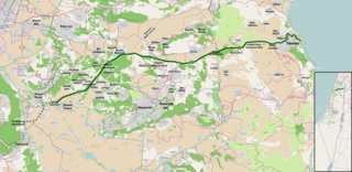
Route 505 is a regional Israeli highway in the Israeli-occupied West Bank.

Route 227 is a 34-kilometre (21 mi) road in the eastern Negev desert of Israel. It starts from an intersection with Route 206 in the northwest and ends in Ir Ovot in the southeast, intersecting with Highway 90. It has one at-grade intersection at 19 km. The original road was laid by British land surveyors in 1927. Prior to 1956, this was the primary route from Beersheba to Eilat.

