Route 386 (Israel)

Last updated
ISR-HW-386.svg
Route 386
כביש 386
ILroute-386.png
NahalSorekRefaimJaffaJerusalemRailroadRoad386Jan272023.jpg
Refaim Bridge, at which the Jaffa–Jerusalem railway is passing below road 386, at the point Nahal Refaim is entering Nahal Sorek
Route information
Length23 km (14 mi)
Major junctions
North endTzur Hadassah Junction
Major intersections
  • Nes Harim Junction
  • Kerem Junction
  • Holland Square
  • Molikovsky Square
  • Denia Square
  • Haft Square
South endJunction at Shazar Blvd
Location
Country Israel
Highway system
ISR-HW-367.svg Route 367 ISR-HW-398.svg Route 398
Sorek Wastewater Treatment Plant in Nahal Sorek, near Road 386 and beside Mount Eitan [he] MountEitanSorekWastewaterTreatmentPlantRoad386NahalSorekJan272023 02.jpg
Sorek Wastewater Treatment Plant in Nahal Sorek, near Road 386 and beside Mount Eitan  [ he ]

Route 386 is a road in Israel that runs from Tzur Hadassah to Jerusalem.

Contents

Route

The route begins as a two-lane undivided road in the Judean Mountains at 730 meters above sea level at Tzur Hadassah Junction with Route 375. [1] It travels west-northwest for 2 km. passing Moshav Bar Giora and Nes Harim Junction with Road 3866 where it turns eastward for 1.2 km. and negotiates a hairpin turn. The road then begins a long winding descent, first west, then north, then east, skirting around the west side of the Har Giora Nature Reserve offering scenic views as it descends into the Sorek Valley. At its lowest point of 550 meters, the road passes Jerusalem's largest sewage treatment facility (Sorek). [2]

It then begins a slow northeasterly ascent as it passes Jerusalem's main electrical substation (Sapir Station) [3] and the Sataf Spring Nature Reserve. [4] Turning more easterly, it enters Jerusalem just before passing below Hadassah Hospital and intersects with Route 395 at Kerem Junction. It continues its ascent via Ein Kerem Street through the neighbourhood of Ein Kerem travelling southeast, then north, then east until Holland Square adjacent to the Bayit VeGan neighbourhood. From this point, Route 386 becomes a boulevard with traffic light-controlled intersections.

The road continues northeasterly as Sderot Herzl (Herzl Boulevard), also known as Tzir Herzl (Herzl Axis), the major north-south route on the west side of the city. [5] Along this portion of the route, tracks were laid for the Jerusalem Light Rail, which began operation in August 2011. The road passes Yad Vashem, the Mount Herzl National Cemetery and Sha'arei Tzedek Medical Center. [6] Between Molikovsky Square at Shmuel Beyth Street and Haft Square at HeHalutz Street, northbound traffic may continue through Beit HaKerem along Herzl Boulevard. Southbound traffic, however, is shunted 0.2 km (0.12 mi). west along the parallel Mordechai Ish-Shalom Street.

After Haft Square, the road travels between the neighbourhoods of Kiryat Moshe and Kiryat HaLeom, passing nearby the Kiryat Moshe Interchange of Highway 50 (Begin Expressway). It ends at 800 meters above sea level at Shazar Boulevard at the main western entrance to Jerusalem at the base of the Jerusalem Chords Bridge and the Binyanei HaUma Convention Center.

Junctions

kmNameTypeMeaningLocationRoad(s) Crossed
0צומת צור הדסה
(Tzur Hadassah Junction)
Zeichen 215 - Kreisverkehr, StVO 2000.svg Rock of Hadassah Tzur Hadassah,
Mevo Beitar,
Mount Kitron
ISR-HW375.png Route 375
1.4 Fareskilt 20.PNG Fire Station entrance road
2צומת בר גיורה
(Bar Giora Junction)
Fareskilt 20.PNG named after
Simon bar Giora
Bar Giora entrance road
2.2צומת נס הרים
(Nes Harim Junction)
Fareskilt 20.PNG Mountain Banner Nes Harim ISR-HW3866.png Road 3866
3.4(hairpin turn) Winding left curve (Israel road sign).png
7(narrow bridge
over rail line)
Narrow bridge.png Tel Aviv–Jerusalem
Rail Line
9.1 Fareskilt 20.PNG Sorek
Water Purification Plant
entrance road
10(narrow bridge
over stream)
Narrow bridge.png Sorek Stream
10.1 Fareskilt 20.PNG JNF Canada Forest
in the Jerusalem Hills
entrance road
11.5 Fareskilt 20.PNG Sapir
electrical substation
entrance road
13.2 Fareskilt 20.PNG Sataf Spring
Nature Reserve
entrance road
14.5 Jerusalem Municipal Boundary
15.6 Fareskilt 20beige.png Hadassah Hospital,
Even Sapir
ISR-HW396.png Route 396
(Kalman Yaakov Mann St.)
16.2צומת כרם
(Kerem Junction)
Zeichen 215 - Kreisverkehr, StVO 2000.svg vineyard ISR-HW395.png Route 395
Ein Kerem Street
16.9 Fareskilt 20beige.png Ein KeremEmek HaTeimanim St.
17.3כיכר קסטל
(Kastel Square)
Fareskilt 20beige.png castle Ein KeremHaHadasim St.
Ha'Ilanot Rd.
17.4כיכר עין כרם
(Ein Kerem Square)
Fareskilt 20beige.png spring of the vineyardEin KeremHaAhayot Rd.
HaHoma Lane
17.5 Fareskilt 20beige.png Ein KeremHaMa'ayan St.
HaSha'ar Alley
17.55 Fareskilt 20beige.png Ein KeremHaOren St.
17.6 Fareskilt 20beige.png Ein KeremHaOrev Alley
17.7 Fareskilt 20beige.png Ein KeremMa'ale HaBustan
17.8 Fareskilt 20beige.png Ein KeremHaYekev Alley
17.9 Fareskilt 20beige.png Winding left curve (Israel road sign).png Ein KeremKarmit Rd.
18.05 Fareskilt 20beige.png Ein KeremHaHoma Lane
18.6 Fareskilt 20beige.png Ein KeremShaul Barkali St.
19.7 Fareskilt 20beige.png Jerusalem Light Rail
Park and ride Facility
entrance
Herzl Boulevard
20כיכר הולנד
(Holland Square)
19-A Israely road sign.svg Tram sign israelbeige.png Yad VaShem,
Bayit VeGan,
Jerusalem Light Rail Station
HaZikaron St.,
HaPisga St.,
Kiryat HaYovel St.
20.2 19-A Israely road sign.svg Bayit VeGanBayit VeGan St.,
HaRav Uziel St.
20.4 19-A Israely road sign.svg Har Herzl entrance road
20.6כיכר מיליקובסקי
(Mileikowsky Square)
19-A Israely road sign.svg named after
Nathan Mileikowsky
Beit HaKerem,
Yefeh Nof,
Sha'arei Tzedek,
Yad Sarah
Shmuel Beyth St.,
Yefeh Nof St.
to Mordechai Ish-Shalom Rd.
20.8(pedestrian crossing) 19-A Israely road sign.svg Pedestrian crossing.png Beit HaKerem,
Yefeh Nof,
Jerusalem Light Rail Station
20.9 19-A Israely road sign.svg Beit HaKerem,
Yefeh Nof
Aharonov St.
21.1 19-A Israely road sign.svg Beit HaKerem,
Yefeh Nof
HaMeyasdim St.,
HaTomer St.
21.2כיכר דניה
(Denia Square)
19-A Israely road sign.svg named to honor the
Danish resistance movement
Beit HaKerem,
Yefeh Nof,
Jerusalem Light Rail Station
HaArazim St.,
Beit HaKerem St.
21.6(pedestrian crossing) 19-A Israely road sign.svg Pedestrian crossing.png Beit HaKerem,
Yefeh Nof,
Jerusalem Light Rail Station
21.8כיכר האפט
(Haft Square)
19-A Israely road sign.svg named after
Avraham Haft
Beit HaKerem,
Yefeh Nof,
Kiryat Moshe
Yehoshua Farbstein St.
(to Mordechai Ish Shalom Rd.),
HeHalutz St.,
Beit HaKerem St.
22.1 19-A Israely road sign.svg Kiryat Moshe,
Kiryat HaLeom
Wolfson Blvd.,
Baron Hirsch St.
22.3(southbound only) 19-A Israely road sign.svg Tram sign israelbeige.png Kiryat Moshelight rail crossing
22.5 19-A Israely road sign.svg Kiryat Moshe,
Kiryat HaLeom
Kiryat Moshe St.,
Rabin Blvd.
to ISR-FW-50.svg Highway 50
22.7 19-A Israely road sign.svg Kiryat Moshe,
Rova Mevo Ha'ir,
Jerusalem Light Rail Station
HaRav Tzvi Yehuda St.
22.9 19-A Israely road sign.svg Givat Shaul,
Romema,
Rova Mevo Ha'ir,
Strings Bridge
Shazar Blvd.

Related Research Articles

<span class="mw-page-title-main">Pisgat Ze'ev</span> Israeli settlement in East Jerusalem

Pisgat Ze'ev is an Israeli settlement in East Jerusalem and the largest residential neighborhood in Jerusalem with a population of over 50,000. Pisgat Ze'ev was established by Israel as one of the city's five Ring Neighborhoods on land effectively annexed after the 1967 Six-Day War.

<span class="mw-page-title-main">Highway 1 (Israel–Palestine)</span> Highway in Israel

Highway 1 is the main highway in Israel, connecting Tel Aviv and Jerusalem, and continuing eastwards to the Jordan Valley in the West Bank.

<span class="mw-page-title-main">Beit HaKerem, Jerusalem</span> Neighborhood in Jerusalem, Israel

Beit HaKerem is a largely secular upscale neighborhood in southwest Jerusalem. It is located between Kiryat Moshe to the northwest and Bayit VeGan to the south. Beit HaKerem has a population of 15,000.

<span class="mw-page-title-main">Kiryat HaYovel</span>

Kiryat HaYovel is a neighborhood in southwestern Jerusalem on Mount Herzl. It was built in the early 1950s to house new immigrants. Today, Kiryat HaYovel has a population of 25,000 residents.

<span class="mw-page-title-main">Jerusalem Light Rail</span> Light rail system in Jerusalem, Israel

The Jerusalem Light Rail is a light rail system in Jerusalem. Currently, the Red Line is the only one in operation, the first of several light rail lines planned in Jerusalem.

<span class="mw-page-title-main">Highway 50 (Israel–Palestine)</span> Road in Israel and Palestine

Highway 50, officially called Begin Boulevard and also referred to as Menachem Begin Expressway or Begin Highway, is a north-south urban freeway, through western Jerusalem, named after Israel's sixth Prime Minister, Menachem Begin. Local Jerusalemites simply refer to it as 'Begin'. It enters Area C of the West Bank on the north end and East Jerusalem on both ends.
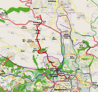
Karmei Tzur, or Carmei Tzur is an Israeli settlement organized as a community settlement in the West Bank located north of Hebron in the Judean hills between the Palestinian towns of Beit Ummar and Halhul. The National Religious community falls under the jurisdiction of Gush Etzion Regional Council. Under the terms of the Oslo Accords of 1993 between Israel and the Palestine Liberation Organization, Karmei Tzur was designated Area "C" under full Israeli civil and security control. In 2021 it had a population of 965.

<span class="mw-page-title-main">Transport in Jerusalem</span>

Transport in Jerusalem is characterized by a well-developed inter-city network and an emerging, developing intra-city network. Ben Gurion International Airport serves as Jerusalem's closest international airport. Egged bus lines and Israel Railways connect the city of Jerusalem to much of Israel, and a high-speed rail line to the airport and Tel Aviv is currently under construction, while the segment to Ben Gurion Airport is already in limited operation. Within the city, the roads, rather than the rails, are the primary mode of transportation.

<span class="mw-page-title-main">Mateh Yehuda Regional Council</span> Regional council

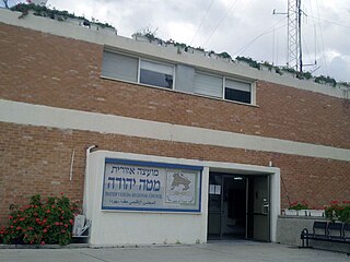
Mateh Yehuda Regional Council is a regional council in the Jerusalem District of Israel. In 2008 it was home to 36,200 people.

<span class="mw-page-title-main">Highway 44 (Israel)</span> Road in Israel

Highway 44 is an arterial road in central Israel. It connects Tel Aviv-Yafo and Holon to Ramla, Lod and the Shefela. It is numbered as a north–south road and follows a north-west to south-east path.

<span class="mw-page-title-main">Tzur Hadassah</span> Place in Jerusalem, Israel

Tzur Hadassah is a local council located in the Jerusalem Corridor, located 12 kilometres (7.5 mi) southwest of Jerusalem, at an altitude of 755 meters above sea level, located on Route 375 west of Betar Ilit, about one kilometer west of the Green Line, adjacent to the Palestinian village of Wadi Fukin. In 2021 it had a population of 11,930. In 2023 it was awarded Local council (Israel) status.

<span class="mw-page-title-main">Route 411 (Israel)</span> Road in Israel

Route 411, is the designation of a regional route in the Shephelah region in Israel running southeasterly consolidating previous local roads and new construction. The western section begins at Highway 42 near Kfar Gevirol in western Rehovot and continues just past Route 410. The central section, completed in June 2014, continues to the entrance of Kvutzat Shiller. The eastern section begins just short of Highway 40 south of Rehovot and terminates at Highway 3 towards Jerusalem, bypassing the towns of Kiryat Ekron and Mazkeret Batya.

<span class="mw-page-title-main">Jerusalem corridor</span> Geographical district between Jerusalem and the Shfela in Israel

The Jerusalem corridor is an area between Jerusalem and the Shephelah in Israel. Its northern border is the old road to Jerusalem; its southern border, the Elah Valley; and its western border, Sha'ar HaGai/Bab el-Wad and the road to Beit Shemesh. The largest towns in the Jerusalem corridor are Beit Shemesh, Mevasseret Zion, Abu Ghosh, Tzur Hadassah and Kiryat Ye'arim.

<span class="mw-page-title-main">Yefeh Nof</span>

Yefeh Nof is a neighborhood in west Jerusalem, founded in 1929. Together with Ramat Beit HaKerem and Givat Beit HaKerem, it is part of the larger Beit HaKerem neighborhood. Its name is one of the seventy poetic names the Hebrew Bible uses for Jerusalem, and literally means "beautiful view".
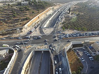
Tzur Shalem is an Israeli outpost attached to the Israeli settlement of Karmei Tzur in The Gush Etzion settlement bloc in the West Bank. The outpost is under the jurisdiction of the Gush Etzion Regional Council. The international community considers Israeli settlements in the West Bank illegal under international law, but the Israeli government disputes this.

<span class="mw-page-title-main">Jerusalem Road 20</span>

Jerusalem Road 20 is a combination of existing roads and new construction creating a continuous route between Jerusalem's Highway 50 and Pisgat Ze'ev via Beit Hanina. The number "20" is a designation used by the Jerusalem Municipality. Several segments of the road follow national road 4197. The cost of the project was NIS 180 million and was completed on 5 May 2013.

<span class="mw-page-title-main">Route 436 (Israel–Palestine)</span> Road in Israel

Route 436 is a regional arterial road in Israel and the West Bank between Jerusalem and Givat Ze'ev. The southern portion begins as a major urban artery in Jerusalem's predominantly Hareidi neighborhoods leading to Highway 50, to Highway 1 and to the northern neighborhood of Ramot. Further north, the road runs alongside portions of Israel's West Bank Barrier as it approaches Givat Ze'ev. It crosses Route 443 to the Tel Aviv area and Highway 45 to Atarot and ends at the Beitunia section of the security barrier. The speed limit begins at 50 km/h along its urban section becoming 70 km/h as it passes through Ramot and then becoming 90 km/h as it leaves the Jerusalem municipality northwards. The road officially ends at the Beitunya cargo transfer terminal.

Kerem Tunnel is a cycling tunnel in southwest Jerusalem, Israel. It is currently the only one in Israel.

References

  1. Shai Mahelel, YnetNews (2005-11-10). "Hiking in Israel". Daily Jews. Retrieved 2013-03-13.
  2. 31.7584057,35.1027281 (Map). Google Maps. Retrieved 2021-06-28.
  3. 31.7585472,35.099209 (Map). Google Maps. Retrieved 2021-06-28.
  4. 31.7705157,35.1279092 (Map). Google Maps. Retrieved 2021-06-28.
  5. Fodor's (1999). Fodor's Israel (7th ed.). Fodor's Travel. p. 548. ISBN   9781400008988.
  6. Semsek, Hans-Günter; Verlag, Nelles; Pfaffenbach, Carmella (1996). Israel. Nelles Verlag GmbH. p. 256. ISBN   9783886184125.

31°46′17.80″N35°09′06.20″E / 31.7716111°N 35.1517222°E / 31.7716111; 35.1517222