This article needs additional citations for verification .(June 2012) |
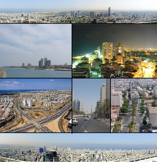
Petah Tikva is a city in the Central District of Israel.
This article needs additional citations for verification .(June 2012) |
Petah Tikva is a city in the Central District of Israel.

Petah Tikva is enclosed by four highways - Geha Highway, Highway 5, Highway 40 and Maccabit Road (Highway 471, which opened in November 2007). Highways 4 and 5 are freeways within Petah Tikva. Road 483 connects Petah Tikva and nearby Rosh HaAyin, and Road 4713 connects it with Kfar Sirkin.
Another major road and perhaps the main transportation artery of the city is Jabotinsky Road (Road 481), which connects Petah Tikva with Bnei Brak, Ramat Gan and Tel Aviv. It is one of the busiest roads in Israel and the Tel Aviv Subway is expected to go through its length.
Petah Tikva has two railway stations – the Segula station, which is located near the Yarkon Interchange and is separated from the rest of the city, and the Kiryat Aryeh station. Both stations are near industrial zones and mainly serve commuters from other towns who work in Petah Tikva, not Petah Tikva's own population.
A railway station existed in a more central area in Petah Tikva in the past, on the former Tel Aviv – Petah Tikva line. Citing the success of the Be'er Sheva Center Railway Station spur, a plan for a train station near the central bus station of Petah Tikva was included in the Israel Railways secondary expansion plan (post-2013). However, it was frozen due to local opposition.
Red Line | ||||||||||||||||||||||||||||||||||||||||||||||||||||||||||||||||||||||||||||||||||||||||||||||||||||||||||||||||||||||||||||||||||||||||||||||||||||||||||||||||||||||||||||||||||||||||||||||||||||||||||||||||||||||||||||||||||||||||||||||||||||||||||||
|---|---|---|---|---|---|---|---|---|---|---|---|---|---|---|---|---|---|---|---|---|---|---|---|---|---|---|---|---|---|---|---|---|---|---|---|---|---|---|---|---|---|---|---|---|---|---|---|---|---|---|---|---|---|---|---|---|---|---|---|---|---|---|---|---|---|---|---|---|---|---|---|---|---|---|---|---|---|---|---|---|---|---|---|---|---|---|---|---|---|---|---|---|---|---|---|---|---|---|---|---|---|---|---|---|---|---|---|---|---|---|---|---|---|---|---|---|---|---|---|---|---|---|---|---|---|---|---|---|---|---|---|---|---|---|---|---|---|---|---|---|---|---|---|---|---|---|---|---|---|---|---|---|---|---|---|---|---|---|---|---|---|---|---|---|---|---|---|---|---|---|---|---|---|---|---|---|---|---|---|---|---|---|---|---|---|---|---|---|---|---|---|---|---|---|---|---|---|---|---|---|---|---|---|---|---|---|---|---|---|---|---|---|---|---|---|---|---|---|---|---|---|---|---|---|---|---|---|---|---|---|---|---|---|---|---|---|---|---|---|---|---|---|---|---|---|---|---|---|---|---|---|---|
| ||||||||||||||||||||||||||||||||||||||||||||||||||||||||||||||||||||||||||||||||||||||||||||||||||||||||||||||||||||||||||||||||||||||||||||||||||||||||||||||||||||||||||||||||||||||||||||||||||||||||||||||||||||||||||||||||||||||||||||||||||||||||||||
The Tel Aviv Light Rail Red Line will pass through Petah Tikva as a ground-level light rail system, expected to be operational in 2022. It is planned to go through Jabotinsky and Orlov streets and works to expand the streets and create public transportation lanes started in 2005, and 2009 work on the first station of the light rail next to the Beilinson Hospital are in progress.
The Red Line depot will also be located in Petah Tikva, next to the Kiryat Aryeh business park.

A number of bus companies operate throughout the city, with numerous terminals. The Egged Bus Cooperative handles inter-city lines, the Dan Bus Company is responsible for lines from Petah Tikva to other cities in the Gush Dan area as well as to the West Bank (but not lines within Petah Tikva), while Afikim handles lines within the city.
The transfer of internal lines from Dan to Kavim was made in April 2006 amid severe opposition from Petah Tikva's residents.[ citation needed ] In 2016, the lines were transferred again from Kavim to Afikim.
The main bus terminal in Petah Tikva is the central bus station. Other terminals include the Sirkin Terminal, Beit Rivka, the Kaplan/Beilinson Terminal and the nearby mall, which is also a large transport hub. The main junctions of the city which serve as major inter-city bus stops are Segula Junction (roads 40/481), Ganim Junction (roads 40/483), Sirkin Junction (roads 40/4713) and Geha Interchange (roads 4/481).
In August 2009, Petah Tikva became the first city in Israel to deploy electronic signs on regular bus stations throughout the city. Six such stations were set up in the pilot run, and 50 are slated eventually. [1]

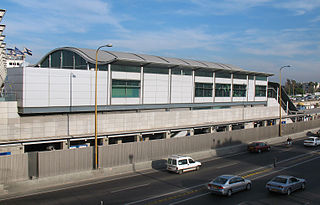
The Petah Tikva central bus station, abbreviated Petah Tikva CBS, is the main bus station in Petah Tikva, Israel. It serves Afikim, Dan, Egged, and Kavim buses. It is officially located on Zeev Orlov St. 64 on one side and Zeev Orlov St. 75 on the other.
The Petah Tikva CBS has four platforms, each of which contains a multitude of small bus stations – two platforms are in an enclosed area to the side of Orlov St. and serve Dan and Kavim buses, while the other two platforms are on Orlov Street itself and serve Egged buses.
As of today, The Petah Tikva CBS is under renovation. Most of the route moved to a temporary terminal called "Moshe Arn Terminal". Only the bus routes of Dan and route 385 of Kavim remained in the Petah Tikva CBS. [2]
The following buses stop at the Petah Tikva CBS or at Modhe Arns Terminal. Many of their routes, especially Egged's, do not originate in the station but come from Tel Aviv.
Notes:
| Line | Route |
|---|---|
| 159 | Petah Tikva CBS – Camp Tzrifin (mornings only) |
| 164 | Petah Tikva CBS – Rehovot CBS (via Rishon LeZion) |
| 249 | Petah Tikva CBS – Rehovot CBS (via Lod, Ramla) |
| 921 | Tel Aviv CBS – Haifa Hof HaCarmel CBS |
| Line | Route |
|---|---|
| 7/7א | Rosh HaAyin Cemetery Terminal – Petah Tikva HaHarash Terminal |
| 10/10א | Petah Tikv CBS – Yoseftal neighborhood |
| 17 | Petah Tikva CBS – Rosh HaAyin Cemetery Terminal |
| 21 | Petah Tikva CBS – Petah Tikva CBS via Kfar Maas |
| 23 | Sgula Industrial Area – Petah Tikva Beit Rivka |
| 25 | Petah Tikva CBS – Petah Tikva Beit Rivka |
| 27 | Rosh HaAyin Cemetery Terminal – Petah Tikva HaHarash Terminal |
| 31 | Petah Tikva CBS – Petah Tikva CBS |
| 41 | Petah Tikva CBS – Kiryat Matalon neighborhood |
| 47 | Giv'at Shmuel – Petah Tikva CBS |
| 49/49א | Petah Tikva CBS – Tel Aviv University |
| 53/53א | Petah Tikva CBS – Hadar HaMoshavot neighborhood |
| 62 | Schneider Terminal – Sgula Industrial Area |
| 67 | Petah Tikva CBS – Petah Tikva Sgula Train Station |
| 81 | Ra'anana – Kedumim Giv'at Shalem neighborhood (alternate route) |
| 83 | Petah Tikva CBS – Sdei Hemed |
| 84 | Petah Tikva CBS – Mazor |
| 87 | Petah Tikva CBS – Tel HaShomer |
| 88 | Petah Tikva CBS – Yarhiv |
| 89/89א | Petah Tikva CBS – Nahshonim |
| 91 | Petah Tikva CBS – Kfar Sirkin |
| 97 | Hadar Ganim neighbirhood - Petah Tikva CBS |
| 99/99א | Amisav – Petah Tikva CBS |

| Line | Route |
|---|---|
| 1 | Petah Tikva CBS – Bat Yam Sports Center |
| 38 | Petah Tikva CBS – Holon Peres Park |
| 51 | Petah Tikva CBS – Tel Aviv CBS |
| 66 | Petah Tikva CBS – Tel Aviv Carmelit Terminal |
| 92 | Petah Tikva CBS – Ramat Gan Ayalon Mall |
| 138 | Petah Tikva CBS – Tel Aviv Arlozorov Terminal |
| Line | Route |
|---|---|
| 76 | Petah Tikva CBS – Or Yehuda |
| 78 | Petah Tikva CBS – Or Yehuda |
| 385 | Petah Tikva CBS – Shoham |
| 641 | Petah Tikva HaHarash Terminal – Netanya CBS |
| Line | Route |
|---|---|
| 551 | Petah Tikva Kiryat Aryeh tailway station – Herzliya railway station |
| 553 | Petah Tikva CBS – Herzliya Marina |
| 561 | Petah Tikva Kiryat Aryeh tailway station – Kfar Saba CBS |
| Line | Route |
|---|---|
| 184 | Petah Tikva CBS – Oranit |
| 185 | Petah Tikva CBS – Etz Efraim |
| 186 | Ariel – Tel Aviv CBS |
| 189 | Immanuel – Bnei Brak |
| 386 | Petah Tikva CBS – Ariel University Center of Samaria (alternate route) |

Petah Tikva, also known as Em HaMoshavot, is a city in the Central District of Israel, 10.6 km (6.6 mi) east of Tel Aviv. It was founded in 1878, mainly by Haredi Jews of the Old Yishuv, and became a permanent settlement in 1883 with the financial help of Baron Edmond de Rothschild.
Gush Dan or Tel Aviv metropolitan area is a conurbation in Israel, located along the country's Mediterranean coastline. There is no single formal definition of Gush Dan though the term is in frequent use by both governmental bodies and the general public. It ranges from combining Tel Aviv with cities that form urban continuum with it to the entire areas from both the Tel Aviv and the Central District or sometimes the whole Metropolitan Area of Tel Aviv. which includes a small part of the Southern District as well. Gush Dan is the largest conurbation and metropolitan area in Israel, with the metropolitan area having an estimated population of 4,156,900 residents, 89% of whom are Israeli Jews.

Rosh HaAyin is a city in the Central District of Israel. In 2021, it had a population of 71,651.
The Tel Aviv Light Rail, also known as Dankal is a planned mass transit system for the Tel Aviv metropolitan area in central Israel. The system will include different modes of mass transit, including rapid transit (metro), light rail transit (LRT), and bus rapid transit (BRT). Overseen by the government agency NTA, the project will complement the intercity and suburban rail network operated by Israel Railways.

Metropoline is an Israeli bus company, which provides bus routes from Beersheba to Tel Aviv and other destinations in the Southern District, Intracity and intercity routes in Ramat HaSharon, Herzliya, Hod HaSharon, Ra'anana, Kfar Saba and other destinations in southern HaSharon. It was founded in 2000 by Tour Bus and two other transportation companies.

Kavim is an Israeli bus company based in Holon. It was founded in 2000 and provided lines in the eastern Gush Dan region - the towns/cities Kiryat Ono, Petah Tikva, Or Yehuda, Givatayim and others. In February 2005, Kavim expanded to the north, where it started providing bus lines in Afula, Bet She'an and the Nazareth area. In 2006, more routes are planned in Petah Tikva and Rosh HaAyin. Many of Kavim's current routes were transferred from the Dan Bus Company. In 2011, the bus company Illit was merged with Kavim. In 2012, Kavim won the tender for the Heshmonaim cluster which includes the cities Ramla, Lod and Modi'in, and the tender for cluster of regional bus routes in the Netanya Hadera area. Kavim started the operate the routes in both clusters in 2013. In 2015, Kavim's bus routes in Afula were transferred to Superbus bus company. In 2017 Kavim won the tender of the Valley of Elah and Beitar Illit cluster that contains routes that Kavim currently operates and few routes of Superbus in the Beit Shemesh area.

Binyamina railway station is an Israel Railways passenger station located in the region of Binyamina-Giv'at Ada and serves these towns, as well as Zikhron Ya'akov, Or Akiva and other small communities in the area.

The Tel Aviv Savidor Central railway station is a major railway station on the Ayalon Railway in central Tel Aviv, Israel, serving most lines of Israel Railways.

Rishon LeZion–HaRishonim railway station is a station of Israel Railways in Rishon LeZion, part of the Tel Aviv – Rishon LeZion line. The station is located in the southern area of the city, in the middle of HaRishonim Interchange, at the intersection of the new Highway 431 and Route 412. It was opened on September 13, 2003 with the Beit Shemesh railway station. The station has two platforms. It is the southern terminus of the suburban line to Netanya.

Tel Aviv HaShalom railway station is a major railway station on the Ayalon Railway in central Tel Aviv, Israel, serving most lines of Israel Railways. It is located in the median of the Ayalon Highway at the HaShalom interchange, near the city's main commercial area and HaKirya IDF base. In 2019, over 15 million passengers used the station, making it the busiest in the country.
Tel Aviv HaHagana railway station is a major railway station on the Ayalon Railway in southern Tel Aviv, Israel, serving most lines of Israel Railways. It is located in the median of the Ayalon Highway, north of Highway 1 and 400 meters east of the Tel Aviv Central Bus Station. In 2019, over six million passengers used the station, making it the third-busiest in the country after the nearby Savidor Central and HaShalom stations at the time; it was subsequently overtaken by Jerusalem–Yitzhak Navon and demoted to fourth place, but remains the third-busiest station in Tel Aviv.

Rehovot railway station is an Israel Railways station located in the city of Rehovot. It serves the city, the Weizmann Institute of Science and the nearby science industries park, as well as the city of Ness Ziona. The station is named after Ehud Hadar, CEO of Israel Railways between 1994 and 1996.

The Tel Aviv transportation system is seen as the hub of the Israeli transport network in terms of road, rail, and air transport. The Israeli road network partly centers on the city, with some of the country's largest highways passing through or running to the city. The city forms a major part of the country's rail network, whilst Ben Gurion International Airport located near the city is the country's largest airport. There is also a strong public transport system within the city, based primarily on bus transportation.

Bnei Brak–Ramat HaHayal railway station is a suburban passenger railway station in Israel, operated by Israel Railways. It is located on the Yarkon Railway near the Bnei Brak–Ramat Gan and Bnei Brak–Tel Aviv borders next to the Ayalon Mall and Ramat Gan Stadium. In spite of its proximity to important industrial and commercial areas of Gush Dan as well as to residential areas of Tel Aviv, Bnei Brak is one of the less-popular stations of Israel Railways, possibly because of its misleading name and lack of awareness. As a result, in an effort to increase the public's awareness of the station, the name of the Ramat HaHayal neighborhood located to the north of the station was added to the station's name in 2016.
Bareket is a moshav in central Israel. Located in the Shephelah around five kilometres north-east of Ben Gurion International Airport and covering 2,500 dunams, it falls under the jurisdiction of Hevel Modi'in Regional Council. In 2021 it had a population of 2,192.
The Red Line will be the first section of a light rail system in the Tel Aviv metropolitan area, known as the Tel Aviv Light Rail. The line will run from Bat Yam in the south to Petah Tikva in the northeast with a significant portion of it underground. The total cost of the red line is estimated at NIS 11 billion or, approximately US$3 billion. Construction began in 2011 and is expected to be completed in May 2023, after numerous delays.

Afikim is an Israel bus company that operates on routes connecting the Gush Dan and Sharon plain regions with the western Samaria region of the West Bank, as well as lines in Ashdod, Yavne, Rosh HaAyin and other locations.
The Yarkon Railway is a double-track railroad following the course of the Yarkon River in the central area of Israel. It is about 15 km long, stretching from the Coastal Railway to the Eastern Railway.
The Purple Line is a light rail transit (LRT) line under construction in the Tel Aviv metropolitan Area in Israel. The line will operate as part of the planned Tel Aviv metropolitan area mass transit system and is expected to be the second line to open. The line will connect the city centre of Tel Aviv with its eastern suburbs of Yehud and Giv'at Shmuel.
| Commuter rail | |
|---|---|
| Metro |
|
| Light rail | |
| Bus rapid transit | |
| Funicular | |
| Cable car | |
Italics: under construction or currently not operational | |
| Roads |
| ||||
|---|---|---|---|---|---|
| Bus operators | |||||
| Rail transport |
| ||||
| Cycling | |||||
| Sea ports | |||||
| Aviation |
| ||||
| Cable cars | |||||
| By city | |||||
| Smart cards | |||||