
The Krayot or Qerayot are a cluster of four small cities and two neighbourhoods of Haifa founded in the 1930s on the outskirts of the city of Haifa, Israel, in the Haifa Bay area.

Highway 6, also known as the Trans-Israel Highway or Cross-Israel Highway, is a major electronic toll highway in Israel. Highway 6 is the first Israeli Build-Operate-Transfer road constructed, carried out mainly by the private sector in return for a concession to collect tolls on the highway for a given number of years. It is also one of the largest infrastructure projects undertaken in Israel.

Highway 20, more commonly known as the Ayalon Highway, or simply Ayalon, is a major inter city freeway in Gush Dan, Israel. The road runs along the eastern border of central Tel Aviv from north to south and connects all of the major highways leading to the city—such as Highway 4 from Ashdod and the Southern regions, Highway 2 from Haifa and the Northern regions, Highway 5 from the East, and Highway 1 from Jerusalem and the Southeast. The Ayalon Highway is heavily used; on an average day, almost 600,000 vehicles enter the freeway. It consists of a multi-lane highway with a multi-track railway located between the opposite travel lanes. Some of the highway's route is along the Ayalon River, hence its name.

Highway 5 or the Trans-Samaria Highway, is one of Israel's main highways, connecting the Mediterranean coast immediately north of Tel Aviv with the central Sharon plain and eastwards to Ariel and other Israeli settlements in the northern West Bank.

Highway 1 is the main highway in Israel, connecting Tel Aviv and Jerusalem, and continuing eastwards to the Jordan Valley in the West Bank.

Haifa Hof HaCarmel railway station is an Israel Railways station serving the city of Haifa, Israel.
Highway 50, officially called Begin Boulevard and also referred to as Menachem Begin Expressway or Begin Highway, is a north-south urban freeway, through western Jerusalem, named after Israel's sixth Prime Minister, Menachem Begin. Local Jerusalemites simply refer to it as 'Begin'. It enters Area C of the West Bank on the north end and East Jerusalem on both ends.

Highway 2 is an Israeli highway located on the coastal plain of the Mediterranean Sea. It begins as a major arterial road within Tel Aviv, becoming a freeway as it exits the city northward, continuing to Haifa. North of Tel Aviv, the highway is also called The Coastal Highway.

Highway 4 is an Israeli highway that runs along Israel's entire coastal plain of the Mediterranean Sea, from the Rosh HaNikra border crossing with Lebanon in the North to the Erez Border Crossing with the Gaza Strip in the South. The highway follows in part the route of the ancient Via Maris.
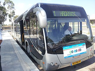
The Metronit, also spelled Matronit, is a bus rapid transit (BRT) system in Haifa, Israel.
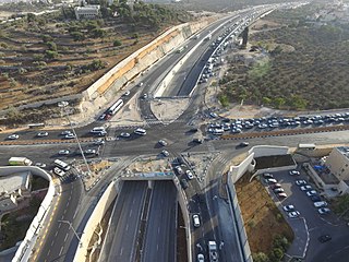
Highway 22, also known as the Bay Highway, is a suburban freeway in the Haifa metropolitan area connecting downtown Haifa with the city's northern exit to the Krayot. From there it continues northwards as a bypass of the Krayot, providing an alternative route to Highway 4.

Highway 471, commonly called Maccabit Road, is a suburban expressway in the center of the Tel Aviv Metropolitan Area in Israel. The expressway connects Highway 4 in the west with Route 444 in the east. It is part of a road system planned to provide improved access to Highway 6.
Highway 7 is a highway in the South District of Israel from Ashdod to Yad Binyamin. It connects the Port of Ashdod with the Trans-Israel Highway.
Highway 9 is an east-west limited-access expressway in Israel that opened to traffic on July 24, 2014.

The Tel Aviv–Jerusalem railway is a railway line in Israel connecting the cities of Tel Aviv and Jerusalem. The line serves as the main rail link between the two cities, complementing the old Jaffa–Jerusalem railway. As such, the railway is often referred to in Israel as the high-speed railway to Jerusalem to distinguish it from the older, longer and slower line. In spite of that name, the line is not high-speed under the definition used by the International Union of Railways: both its design speed of 200 km/h (125 mph) and its current operational speed of 160 km/h (99 mph) are below the 250 km/h (155 mph) threshold used by the UIC to define high-speed railways, and it is traversed by IR's regular rolling stock instead of the UIC requirement for specially-designed high-speed trains.

Route 531, is a suburban freeway in the southern Sharon region of Israel, just north of the Tel Aviv Metropolitan Area. The highway begins at Highway 6 and terminates at the Ayalon Highway with an extension to the Coastal Highway.
Maccabi Ironi Tirat HaCarmel Football Club is an Israeli football club based in Tirat Carmel. They are currently in Liga Gimel, the fifth tier.

The A1, also commonly Rruga e Kombit or SH10, is the longest and only toll motorway in Albania, stretching 114 kilometres (71 mi) in the counties of Lezhë and Kukës. It consists for the most part of two traffic lanes and an emergency lane in each driving direction separated by a central reservation.
China Civil Engineering Construction Corporation Ltd. was established in June 1979 under the approval of the State Council of the People's Republic of China.

Highway 45 is the official designation of a 3.3 km stretch of road forming a continuous connection between Route 443 from the Tel Aviv Metropolitan Area and Highway 50 to central Jerusalem and a 1.4 km spur serving the Atarot Industrial Park.


