
Yeruham is a town in the Southern District of Israel, in the Negev desert. It covers 38,584 dunams, and had a population of 11,170 in 2022. It is named after the Biblical Jeroham.
Highway 40 is a north-south intercity road in Israel. At 302 km long, it is the second longest highway in Israel, after Highway 90. The highway runs from Kfar Saba in the center of Israel to the Arabah in the south, serving as a main connection between central Israel and Be'er Sheva.

Highway 10 is a road in the South District of Israel. It is one of the longest routes in Israel, extending for nearly the entire border of Israel with Egypt from the Gaza Strip in the north to Sayarim junction in the south. Under a military security advisory, its entire 113-mile length is almost permanently off-limits to civilian traffic.
Highway 31 is an inter-city highway in southern Israel. It begins at Lakiya Interchange with Highway 6 at Lakiya. It passes through Hura, Kuseife, Arad, and it terminates at Zohar Junction with Highway 90 south of Neve Zohar just west of the Dead Sea.

The Petroleum Road or Tapline Road is a 47 km (29 mi) long, privately owned north-south asphalt road in the Golan Heights. The name Petroleum Road derives from the now defunct oil pipeline of the Trans-Arabian Pipeline Company, which the road runs adjacent to. It begins near Mount Peres on the east edge of the central Golan and ends in the northern Golan near the Israeli-occupied Golan-Lebanese frontier, nearby Ghajar.
The Railway to Beersheba is a railroad line that runs from central Israel to the Zin Factories in southern Israel, with a spur to the Be'er Sheva Center Railway Station and branch lines to Ramat Hovav, the Arad phosphate mines and factories in Tzefa, and a connection to the Ashkelon–Beersheba railway. It is part of the main line of Israel Railways, of which the northern starting point of the line designated as the "line to Beersheba" is usually indicated as beginning at Na'an junction, where the railway splits to Beersheba and Jerusalem. Because the line is not limited to Beersheba, it is known in Israel as Mesilat HaDarom.

Highway 73 is a highway in the Jezreel Valley in northern Israel. It proceeds from the Nahalal junction in the west toward the Adashim junction in the east. It is 12 km long.
Route 866 is a north-south regional highway in northern Israel. It begins at Hananya junction with Highway 85 in the south and ends at Meron junction with Highway 89 in the north.

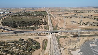
Route 411, is the designation of a regional route in the Shephelah region in Israel running southeasterly consolidating previous local roads and new construction. The western section begins at Highway 42 near Kfar Gevirol in western Rehovot and continues just past Route 410. The central section, completed in June 2014, continues to the entrance of Kvutzat Shiller. The eastern section begins just short of Highway 40 south of Rehovot and terminates at Highway 3 towards Jerusalem, bypassing the towns of Kiryat Ekron and Mazkeret Batya.
The 1958–59 Liga Alef season saw Bnei Yehuda win the title and promotion to Liga Leumit.
The Israeli city of Beersheba occupies a central role in southern Israel. Because of its central position in the Negev it is situated on important national routes reaching down to the far southern port of Eilat. Be'er Sheva is also home to a population of 195,000, with an estimated metro population at over 500,000 making it one of the largest cities in Israel. Much of the cities high-tech industry is concentrated in the center of the city, with Industrial estates existing in the south of the city, both of these areas are thus extensively served.
The 1968–69 Israel State Cup was the 30th season of Israel's nationwide football cup competition and the 15th after the Israeli Declaration of Independence.
The 10th Anniversary Cup was a stand-alone cup competition played to celebrate the 10th anniversary of the Israeli Declaration of Independence.
Hapoel Yeruham is an Israeli football club based in Yeruham. The club is currently in Liga Bet Sout B division.
Hapoel Dimona was an Israeli football club based in Dimona.
Highway 989 is a regional route in the northern Golan, connecting Sa'ar on Highway 99 with Majdal Shams on Highway 98.

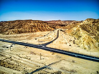
The Petroleum Road or Tapline Road is a transverse road that was paved in 1941 by the Iraq Petroleum Company, hence its name. Today the route is marked as Route 224 in the western part connecting the Negev junction to Yeruham, a short section on Route 204 in the middle, and Route 225 in the eastern part, from Yeruham to HaMakhtesh HaGadol. Added to these is a dirt road about two kilometres long inside HaMakhtesh HaGadol.
Route 222 is a regional arterial road in the Negev that connects the Mash'abim Junction within the Ramat Negev Regional Council and the Gvulot Junction within the Eshkol Regional Council. The length of the road is 46 km (29 mi).

Route 784 is a regional highway in Northern Israel, which serves as a main transportation artery for the residents of the Misgav Regional Council and connects the Jezreel Valley with the Galilee settlements by the shortest route. The road starts at the Yiftahel interchange in the south and ends at the West Karmiel interchange in the north. From the Misgav junction to the Yuvalim junction, the road overlaps with Route 805. The length of the road is 26 km (16 mi).
Highway 67 is a highway in northern Israel and is one of the two main traffic arteries that cross the Carmel while connecting the coastal plain to Highway 6. The length of the road is 13 km (8.1 mi). The road starts at the Zikhron Ya'akov interchange and ends at the Ein Tut interchange at the junction with Highway 6.
