
Gib Heath (historically Gibb Heath or Gibheath) is a small area of Birmingham, England. [1] It is an inner-city area generally considered to be a part of Handsworth. [2]
Gib Heath (historically Gibb Heath or Gibheath) is a small area of Birmingham, England. [1] It is an inner-city area generally considered to be a part of Handsworth. [2]
Balsall Heath is an inner-city area of Birmingham, West Midlands, England. It has a diverse cultural mix of people and is the location of the Balti Triangle.
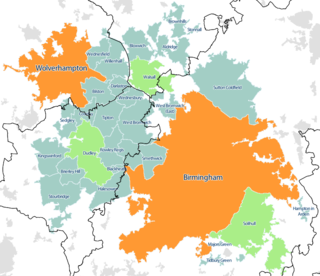
The West Midlands conurbation is the large conurbation that includes the cities of Birmingham and Wolverhampton and the towns of Sutton Coldfield, Dudley, Walsall, West Bromwich, Solihull, Stourbridge and Halesowen in the English West Midlands.

Gravelly Hill is an area of Birmingham, United Kingdom.

Short Heath is an area of Birmingham, England near to Erdington. The area's postcode is B23.

Birmingham Hodge Hill is a constituency of part of the city of Birmingham represented in the House of Commons since 2004 by Liam Byrne, a member of the Labour Party.

Birmingham, Sparkbrook and Small Heath was a parliamentary constituency represented in the House of Commons of the Parliament of the United Kingdom. It elected one Member of Parliament (MP) by the first-past-the-post system of election. The constituency was notable for having the largest percentage of Muslim voters of any UK constituency at 48.8%.
Falcon Lodge is the area of Sutton Coldfield, Birmingham, West Midlands, England, covered in predominantly council houses forming the Falcon Lodge Estate. It is located between Whitehouse Common and Reddicap Heath. To the west of the estate lies Rectory Park. It forms part of the edge of the Sutton Coldfield conurbation and the English countryside.
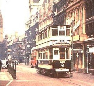
Birmingham Corporation Tramways operated a network of tramways in Birmingham from 1904 until 1953. It was the largest narrow-gauge tramway network in the UK, and was built to a gauge of 3 ft 6 in. It was the fourth largest tramway network in the UK behind London, Glasgow and Manchester.

Salvacañete is a municipality located in the province of Cuenca, Castile-La Mancha, Spain. According to the 2006 census (INE), the municipality has a population of 318 inhabitants. On January 12, 2021, a minimum temperature of −16.2 °C (2.8 °F) was registered.
Bournville College is a further education college based in Longbridge, Birmingham, England. The college offers courses that include A Levels, BTECs, NVQs, Apprenticeships and bespoke qualifications.

Warstock is a district within the city of Birmingham, UK, in the southernmost suburbs roughly 1 km east of the A435 and within the ward of Highter's Heath. The area lies within the B14 postcode and is contiguous with Yardley Wood to the north-east, Solihull Lodge to the south-east and Highter's Heath to the south-west. Kings Heath lies to the north-west.

Central Jamia Mosque Ghamkol Sharif is a Sunni mosque in Small Heath area of Birmingham, England.
Little Bromwich is a small area in Central Birmingham, England. It borders with Bordesley Green and Small Heath and there is a road named after it. It is also quite close to Yardley.

Brandwood End is a locality in Birmingham, England, and makes up the central part of the Brandwood electoral ward. It lies within the B14 postcode and is a sub-area of Kings Heath. The area is centred on Brandwood End Cemetery.
Walker's Heath is a small area spanning the southern border of the city of Birmingham, England and the Bromsgrove District of Worcestershire. It is located to the immediate south-east of the Birmingham suburb of Kings Norton.

Charlie-Gibbs Fracture Zone is a system of two parallel fracture zones. It is the most prominent interruption of the Mid-Atlantic Ridge between the Azores and Iceland. It can be traced over more than 2000 kilometers, all the way from north-east of Newfoundland to south-west of Ireland. It took 90 million years for the fault to grow to this length.
The As-Salafi Mosque, also known as "The Salafi Mosque" or "Wright Street", is a Salafi mosque founded in 2002 and located in the Small Heath area of Birmingham, metres from the intersection of Muntz and Wright Streets and just behind Coventry Road. The mosque is contained within the same building and connected to the registered charity and Islamic materials publisher Salafi Publications and the "SalafiBookstore".
Highter's Heath is a district and ward lying on the southern boundary of the city of Birmingham, UK. The district of Highter's Heath lies immediately east of the Maypole. The first recorded use of the name dates from 1495 as Heyters Heath, however today the name is not one that is particularly in widespread use, indeed only three signposted references to the name exist, when entering the city along Maypole Lane, when entering the city from the bottom of Highters Heath Lane and in Major's Green.
Holy Trinity Catholic School is a co-educational secondary school located in the Small Heath area of Birmingham, in the West Midlands of England.
King Edward VI Sheldon Heath Academy is a mixed secondary school and sixth form located in the Sheldon area of Birmingham, in the West Midlands of England.
Coordinates: 52°30′00″N1°55′26″W / 52.500°N 1.924°W
| | This West Midlands location article is a stub. You can help Wikipedia by expanding it. |
