Related Research Articles

The Baja California Peninsula is a peninsula in Northwestern Mexico. It separates the Pacific Ocean from the Gulf of California. The peninsula extends 1,247 km from Mexicali, Baja California in the north to Cabo San Lucas, Baja California Sur in the south. It ranges from 40 km at its narrowest to 320 km at its widest point and has approximately 3,000 km of coastline and approximately 65 islands. The total area of the Baja California Peninsula is 143,390 km2 (55,360 sq mi), roughly the same area as the country of Nepal.

The Gulf of California, also known as the Sea of Cortés or Sea of Cortez, or less commonly as the Vermilion Sea, is a marginal sea of the Pacific Ocean that separates the Baja California Peninsula from the Mexican mainland. It is bordered by the states of Baja California, Baja California Sur, Sonora, and Sinaloa with a coastline of approximately 4,000 km (2,500 mi). Rivers that flow into the Gulf of California include the Colorado, Fuerte, Mayo, Sinaloa, Sonora, and the Yaqui. The surface of the gulf is about 160,000 km2 (62,000 sq mi). Maximum depths exceed 3,000 meters (9,800 ft) because of the complex geology, linked to plate tectonics.
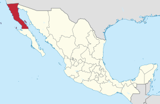
Baja California, officially the Free and Sovereign State of Baja California is a state in Mexico. It is the northernmost and westernmost of the 32 federal entities of Mexico. Before becoming a state in 1952, the area was known as the North Territory of Baja California. It has an area of 70,113 km2 (27,071 sq mi) and comprises the northern half of the Baja California Peninsula, north of the 28th parallel, plus oceanic Guadalupe Island. The mainland portion of the state is bordered on the west by the Pacific Ocean; on the east by Sonora, the U.S. state of Arizona, and the Gulf of California; on the north by the U.S. state of California; and on the south by Baja California Sur.
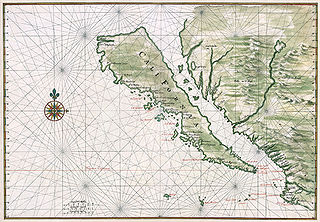
The Island of California refers to a long-held European misconception, dating from the 16th century, that the Baja California Peninsula was not part of mainland North America but rather a large island separated from the continent by a strait now known as the Gulf of California.

The Peninsular Ranges are a group of mountain ranges that stretch 1,500 km (930 mi) from Southern California to the southern tip of the Baja California Peninsula; they are part of the North American Coast Ranges, which run along the Pacific Coast from Alaska to Mexico. Elevations range from 500 to 10,834 feet.

This is a list of the extreme points of North America: the points that are highest and lowest, and farther north, south, east or west than any other location on the continent. Some of these points are debatable, given the varying definitions of North America.

San Felipe is a town on the bay of San Felipe in the Gulf of California in the Mexican state of Baja California, 190 km south of the United States border. Formerly a delegacíon or borough in the municipality of Mexicali, it became the seat of San Felipe Municipality in 2022. The population of San Felipe was reported as 17,143 inhabitants in the 2020 Mexican Census, and can increase by up to 10,000 due to the presence of mostly retired Canadian and U.S. part and full-time residents, desert racing crowds, and though less than in past decades, spring break revelers.
The Yuma Desert is a lower-elevation section of the Sonoran Desert in the southwestern United States and the northwest of Mexico. It lies in the Salton basin. The desert contains areas of sparse vegetation and has notable areas of sand dunes. With an average rainfall less than 8 inches (200 mm) each year, this is among the harshest deserts in North America. Human presence is sparse throughout, the largest city being Yuma, Arizona, on the Colorado River and the border of California.

Federal Highway 1 is a free (libre) part of the federal highway corridors of Mexico, and the highway follows the length of the Baja California Peninsula from Tijuana, Baja California, in the north to Cabo San Lucas, Baja California Sur, in the south. The road connects with Via Rapida, which merges into the American Interstate 5 (I-5) at the San Ysidro Port of Entry, which crosses the international border south of San Ysidro, California.

Mexicali Municipality is a municipality in the Mexican state of Baja California. Its municipal seat is located in the city of Mexicali. As of 2020, the municipality had a total population of 1,049,792. The municipality has an area of 13,700 km2 (5,300 sq mi). This includes many smaller outlying communities as well as the city of Mexicali. Also, the islands of Baja California located in the Gulf of California are part of the municipality, among them the mudflat islands at the mouth of the Colorado River, Isla Ángel de la Guarda and the islands of the San Lorenzo Marine Archipelago National Park. Mexicali is the northernmost municipality of Latin America.

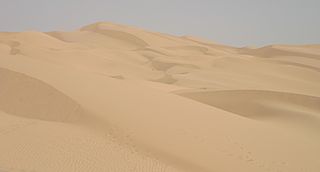
The Gran Desierto de Altar is one of the major sub-ecoregions of the Sonoran Desert, located in the State of Sonora, in northwest Mexico. It includes the only active erg dune region in North America. The desert extends across much of the northern border of the Gulf of California, spanning more than 100 kilometres (62 mi) east to west and over 50 kilometres (31 mi) north to south. It constitutes the largest continuous wilderness area within the Sonoran Desert.

The Lower Colorado River Valley (LCRV) is the river region of the lower Colorado River of the southwestern United States in North America that rises in the Rocky Mountains and has its outlet at the Colorado River Delta in the northern Gulf of California in northwestern Mexico, between the states of Baja California and Sonora. This north–south stretch of the Colorado River forms the border between the U.S. states of California/Arizona and Nevada/Arizona, and between the Mexican states of Baja California/Sonora.
The Hardy River is a 26-kilometer (16 mi)-long Mexican river formed by residual agricultural waters from the Mexicali Valley, and running into the Colorado River. The river is believed to have been an ancient channel of the Colorado. In the 19th century, an English lieutenant, R. W. H. Hardy, explored the Colorado River Delta, and noted that the main channel of the Colorado followed this course. Later, in the 1880s, sea captains noted that the main channel of the Colorado had moved east; this earlier channel became known as Hardy's Colorado.

Montague Island, known in Spanish as Isla Montague, is an island at the mouth of the Colorado River in the municipality of Mexicali, Baja California, Mexico, and is part of the Colorado River Delta and part of a broader region called the Salton Trough. It is about 32 km (20 mi) in length along its longest axis.
Indian Wells is a former settlement in Imperial County, California. It was located 8 miles (13 km) south-southwest of Seeley.
San Luis Río Colorado is a municipality in Sonora state, in northwestern Mexico.

Port Isabel was a seaport established on Port Isabel Slough in 1865 during the American Civil War in Sonora, Mexico in the mouth of the Colorado River on the Gulf of California. It was founded to support the increased river traffic caused by the gold rush that began in 1862 on the Colorado River and the Yuma Quartermaster Depot newly established in 1864 to support the Army posts in the Arizona Military District. The slough was discovered in 1865 by the Captain W. H. Pierson of the schooner Isabel, that first used the slough to transfer its cargo to steamboats safe from the tidal bore of the Colorado River. Shortly afterward Port Isabel was established 3 miles up the slough and replaced Robinson's Landing as the place where cargo was unloaded in the river from seagoing craft on to flat bottomed steamboats of the Colorado River and carried up to Fort Yuma and points further north on the river.
Port Isabel Slough was a deep slough in the Colorado River Delta near the mouth of the Colorado River during the 19th century, within the state of Sonora, Mexico.
Philips Point was a promontory on the north east bank of the Colorado River in Sonora, Mexico, that marked the mouth of the tidal estuary of the Colorado River in the later 19th century.
References
- ↑ The west coasts of Mexico and Central America from the United States to Panama including the gulfs of California and Panama: Chiefly from surveys by the United States steamers Narragansett, Tuscarora, Ranger, and Thetis, between 1873 and 1901; United States Hydrographic Office; Government Printing Office, 1904. pp.155-157
Coordinates: 31°44′43″N114°37′44″W / 31.74528°N 114.62889°W
Colorado River system | |||||||||
|---|---|---|---|---|---|---|---|---|---|
| Jurisdictions |
|     | |||||||
| Canyons |
| ||||||||
| Natural features |
| ||||||||
| Tributaries | |||||||||
| Engineering |
| ||||||||
| Designated areas | |||||||||
| Related topics | |||||||||