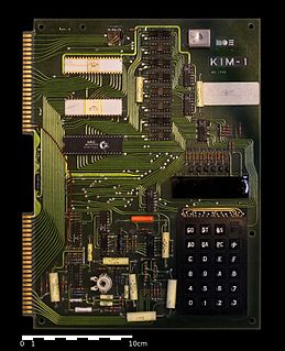
The KIM-1, short for Keyboard Input Monitor, is a small 6502-based single-board computer developed and produced by MOS Technology, Inc. and launched in 1976. It was very successful in that period, due to its low price and easy-access expandability.

Ponsacco is a comune (municipality) in the Province of Pisa in the Italian region Tuscany, located about 50 kilometres (31 mi) southwest of Florence and about 20 kilometres (12 mi) southeast of Pisa.

The Diocese of Allegheny is a former Roman Catholic diocese of the United States (1876–1889). It is currently a Latin episcopal titular see. In Latin, the see is known as Dioecesis Alleghenensis.

NGC 2359 is an emission nebula in the constellation Canis Major. The nebula is approximately 3,670 parsecs away and 30 light-years in size. The central star is the Wolf-Rayet star WR7, an extremely hot star thought to be in a brief pre-supernova stage of evolution. It is similar in nature to the Bubble Nebula, but interactions with a nearby large molecular cloud are thought to have contributed to the more complex shape and curved bow-shock structure of Thor's Helmet.

WR 7 is a Wolf–Rayet star in the constellation of Canis Major. It lies at the centre of a complex bubble of gas which is shocked and partially ionised by the star's radiation and winds.

Dichloropane ((−)-2β-Carbomethoxy-3β-(3,4-dichlorophenyl)tropane, RTI-111, O-401) is a stimulant of the phenyltropane class that acts as a serotonin–norepinephrine–dopamine reuptake inhibitor (SNDRI) with IC50 values of 3.13, 0.79 and 18 nM, respectively. In animal studies, dichloropane had a slower onset and longer duration of action compared to cocaine.
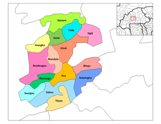
Dacissé is a town in the Nanoro Department of Boulkiemdé Province in central western Burkina Faso. It has a population of 2,070.

Poéssi is a town in the Nanoro Department of Boulkiemdé Province in central western Burkina Faso. It has a population of 2,488.
Soala is a town in the Nanoro Department of Boulkiemdé Province in central western Burkina Faso. It has a population of 2,162.
Soum, Boulkiemdé is a town in the Nanoro Department of Boulkiemdé Province in central western Burkina Faso. It has a population of 2,392.

Mastuj is a town and Tehsil of Chitral District in Khyber-Pakhtunkhwa province of Pakistan. It is located at 36°17'0N 72°31'0E with an altitude of 2359 metres. There are ruins of old fort built originally in 18th century and re constructed later couple of times.
Dùn Meadhonach is a hillfort located on the Inner Hebridean island of Colonsay, Scotland. The site is located at grid reference NR36509472.

WD 2359-434 is a nearby degenerate star of spectral class DAP5.8, the single known component of the system, located in the constellation Phoenix, the nearest star in this constellation.
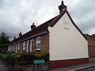
Garrett's Almshouses are Grade II listed almshouses on Wood Street, Chipping Barnet. The houses were constructed in 1729.

The 2015 World Draughts Championship at the international draughts was held November 8–24, 2015 at Emmen, Netherlands International Draughts Federation FMJD. Twenty players were competing in the tournament. It was played as a round-robin, with 19 rounds in total, each of which be micro-match from two games. The winning prize for the tournament was 25,000 euros.

German submarine U-2359 was a Type XXIII U-boat of Nazi Germany's Kriegsmarine during World War II. She was ordered on 20 September 1944, and was laid down on 3 November 1944 at Deutsche Werft AG, Hamburg, as yard number 513. She was launched on 23 December 1944 and commissioned under the command of Oberleutnant zur See Gustav Bischoff on 16 January 1945.
Mile and a Quarter is a populated place in the parish of Saint Peter, Barbados.

Boyne Castle is a 16th-century quadrangular castle about 1.5 miles (2.4 km) east of Portsoy, Aberdeenshire, Scotland, 0.5 miles (0.80 km) south of Boyne Bay.
Nolensville High School is a high school in Nolensville, Tennessee. It opened in 2016. The school is located in northeastern Williamson County. The school is located in the expanding town of Nolensville. As of 2018, the school has grades 9-12.