Siglé Department

Last updated
Siglé
Department
Boulkiemde departments.png
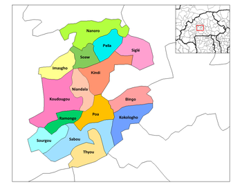
Siglé Department location in the province
Country Flag of Burkina Faso.svg  Burkina Faso
Province Boulkiemdé Province
Population (2005)
  Total 31,279
Time zone GMT 0 (UTC+0)

Siglé is a department or commune of Boulkiemdé Province in central Burkina Faso. As of 2005 it has a population of 31,279. Its capital lies at the town of Siglé. [1]

Departments of Burkina Faso administrative division and commune of Burkina Faso

The provinces of Burkina Faso are divided into 351 departments, whose urbanized areas are grouped into the same commune (municipality) with the same name as the department. The 351 communes created in those departments have three kinds of status :

Boulkiemdé Province Province in Centre-Ouest Region, Burkina Faso

Boulkiemdé is one of the 45 provinces of Burkina Faso and is in Centre-Ouest Region. The capital of Boulkiemdé is Koudougou. The population of Boulkiemdé was 498,008 in 2006 and 567,680 in 2011.

Burkina Faso country in Africa

Burkina Faso is a landlocked country in West Africa. It covers an area of around 274,200 square kilometres (105,900 sq mi) and is surrounded by six countries: Mali to the north; Niger to the east; Benin to the southeast; Togo and Ghana to the south; and Ivory Coast to the southwest. The July 2018 population estimate by the United Nations was 19,751,651. Burkina Faso is a francophone country, with French as the official language of government and business. Roughly 40% of the population speaks the Mossi language. Formerly called the Republic of Upper Volta (1958–1984), the country was renamed "Burkina Faso" on 4 August 1984 by then-President Thomas Sankara. Its citizens are known as Burkinabé. Its capital is Ouagadougou.

Towns and villages

 · Siglé  · Balogho  · Bologo  · Boukou  · Dacissé  · Daurnogomdé  · Kouria  · Lallé  · Makoula  · Nafougo  · Palagré  · Palilgogo  · Séguédin  · Semtenga  · Temnaoré  · Tia  · Tio  · Yargo

Siglé Place in Centre-Ouest Region, Burkina Faso

Siglé is a town in the Siglé Department of Boulkiemdé Province in central western Burkina Faso. It is the capital of Siglé Department and has a population of 2,224.

Balogho is a town in the Siglé Department of Boulkiemdé Province in central western Burkina Faso. It has a population of 1,428.

Bologo Place in Centre-Ouest Region, Burkina Faso

Bologo is a town in the Siglé Department of Boulkiemdé Province in central western Burkina Faso. It has a population of 6,029.

Related Research Articles

Morris No. 312 is a rural municipality in north-central Saskatchewan, Canada on the South Saskatchewan River. It is located in Division No. 15.

Greenwood Springs, Mississippi Place

Greenwood Springs is an unincorporated community in Monroe County, Mississippi.

Heavener High School is a public high school located in Heavener, Oklahoma.

Makoula is a town in the Siglé Department of Boulkiemdé Province in central western Burkina Faso. It has a population of 2,191.

Palagré is a village in the Siglé Department of Boulkiemdé Province in central western Burkina Faso. It has a population of 369.

Cropseyville is a hamlet in Rensselaer County, New York. It comprises the ZIP code of 12052. It is located east of the city of Troy, in the town of Brunswick.

Oak Grove, Calaveras County, California Unincorporated community in California, United States

Oak Grove is an unincorporated community in Calaveras County, California. It lies at an elevation of 292 feet.

Aukum, California Unincorporated community in California, United States

Aukum is an unincorporated community in El Dorado County, California. It is located 1 mi (1.6 km) northeast of River Pines, 1.2 mi (1.8 km) south of Mount Aukum and 8.5 mi (13.7 km) northeast of Plymouth, at an elevation of 2155 feet. The ZIP code is 95656.

Beni Ouarsous is a town and commune in Tlemcen Province in northwestern Algeria.

Beni khellad is a town and commune in Tlemcen Province in northwestern Algeria.

Radio Nacional de Venezuela The signal that crosses the Homeland.

Radio Nacional de Venezuela is a government radio station in Venezuela. Broadcasting began in 1936. The station is currently run by the Venezuelan governments Ministry of Popular Power for Communication and Information (MINCI).

Collège de Rosemont

Collège de Rosement is a French public college in Montreal (Quebec), Canada. The school was founded in September 1954 by Father Gerard Cornellier. It is located at 6400 16th avenue, corner Beaubien Street in the borough of Rosemont–La Petite-Patrie.

Opekiska was an unincorporated community located in Monongalia County, West Virginia. The Opekiska Post Office is no longer open.

Church of San Francisco, Ceuta

Iglesia de San Francisco is a church in the Spanish city of Ceuta, bordering northern Morocco. It stands at the side of the Plaza de los Reyes, and is a distinctive Baroque twin-towered yellow building. It was built in the early eighteenth century in honour of the Holy Cross and is noted for its Baroque altarpieces and images of the Virgin and Christ.

Playa de la Ribera

Playa de la Ribera is a beach of Ceuta, a Spanish city bordering northern Morocco. Like the Playa del Chorillo, it lies to the south of the isthmus, but on the part where it joins the mainland. It is about 405 metres long, with an average width of 40 metres. It is very busy during the summer months.

Pardus is an unincorporated community in Jefferson County, in the U.S. state of Pennsylvania.

Mineral Springs is an unincorporated community in Adams County, Ohio.

Hubbells is an unincorporated community in Butler County, in the U.S. state of Missouri.

Mahan Crossing, Indiana Unincorporated community in Indiana, United States

Mahan Crossing is an unincorporated community in Stampers Creek Township, Orange County, in the U.S. state of Indiana.

Ames, Indiana Unincorporated community in Indiana, United States

Ames is an unincorporated community in Union Township, Montgomery County, in the U.S. state of Indiana.

References

Coordinates: 12°33′26″N1°53′13″W / 12.55722°N 1.88694°W / 12.55722; -1.88694

Geographic coordinate system Coordinate system

A geographic coordinate system is a coordinate system that enables every location on Earth to be specified by a set of numbers, letters or symbols. The coordinates are often chosen such that one of the numbers represents a vertical position and two or three of the numbers represent a horizontal position; alternatively, a geographic position may be expressed in a combined three-dimensional Cartesian vector. A common choice of coordinates is latitude, longitude and elevation. To specify a location on a plane requires a map projection.