Ramongo | |
---|---|
Department | |
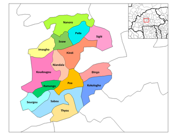
Ramongo Department location in the province | |
Country | |
Province | Boulkiemdé Province |
Population (2005) | |
• Total | 28,326 |
Time zone | GMT 0 (UTC+0) |
Ramongo is a department or commune of Boulkiemdé Province in central Burkina Faso. As of 2005 it has a population of 28,326. Its capital lies at the town of Ramongo. [1]
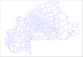
The provinces of Burkina Faso are divided into 351 departments, whose urbanized areas are grouped into the same commune (municipality) with the same name as the department. The 351 communes created in those departments have three kinds of status :
Boulkiemdé is one of the 45 provinces of Burkina Faso and is in Centre-Ouest Region. The capital of Boulkiemdé is Koudougou. The population of Boulkiemdé was 498,008 in 2006 and 567,680 in 2011.
Burkina Faso is a landlocked country in West Africa. It covers an area of around 274,200 square kilometres (105,900 sq mi) and is surrounded by six countries: Mali to the north; Niger to the east; Benin to the southeast; Togo and Ghana to the south; and Ivory Coast to the southwest. The July 2018 population estimate by the United Nations was 19,751,651. Burkina Faso is a francophone country, with French as the official language of government and business. Roughly 40% of the population speaks the Mossi language. Formerly called the Republic of Upper Volta (1958–1984), the country was renamed "Burkina Faso" on 4 August 1984 by then-President Thomas Sankara. Its citizens are known as Burkinabé. Its capital is Ouagadougou.
Ramongo · Bayandi Nabyiri · Bayandi Palogo · Bayandi Tanguin · Bouloum Nabyiri · Kabinou · Kamsi · Kolonkandé · Koukinkuilga · Ramongo-Tanguin · Ramonkodogo · Salbisgo-Dapoya · Salgisgo-Itaoré · Yagoam
Ramongo is a town in the Ramongo Department of Boulkiemdé Province in central western Burkina Faso. It is the capital of the Ramongo Department and has a population of 2,500.
Bayandi Nabyiri is a town in the Ramongo Department of Boulkiemdé Province in central western Burkina Faso. It has a population of 1,041.
Bayandi Palogo is a town in the Ramongo Department of Boulkiemdé Province in central western Burkina Faso. It has a population of 1,489.
Shizuishan is a prefecture-level city and is the northernmost and, by population, the second-largest city in the Ningxia Hui Autonomous Region, and is bordered on all sides except the south by Inner Mongolia. It also sits on the western (left) bank of the Yellow River.
Saint Patrick is an administrative parish of Saint Vincent and the Grenadines, on the island of Saint Vincent. The parish consists of the middle portion of the leeward side of the main island. Its capital is Barrouallie.
Grenadines is an administrative parish of Saint Vincent and the Grenadines, comprising the islands of the Grenadines other than those belonging to Grenada. The capital is Port Elizabeth.
Saint Andrew is an administrative parish of Saint Vincent and the Grenadines, on the island of Saint Vincent. Its capital is Layou.
Revilla Vallejera is a municipality and town located in the province of Burgos, Castile and León, Spain. According to the 2004 census (INE), the municipality has a population of 119 inhabitants.
Bouloum Nabyiri is a town in the Ramongo Department of Boulkiemdé Province in central western Burkina Faso. It has a population of 1,946.
Bayandi Tanguin is a town in the Ramongo Department of Boulkiemdé Province in central western Burkina Faso. It has a population of 1,453.
Ramongo-Tanguin is a town in the Ramongo Department of Boulkiemdé Province in central western Burkina Faso. It has a population of 2,520.
Haskell Glacier is a small glacier descending from the Christoffersen Heights and draining west between Prism Ridge and the Forbidden Rocks, in the Jones Mountains of Antarctica. It was mapped by the University of Minnesota Jones Mountains Party, 1960–61, and was named by the Advisory Committee on Antarctic Names for Lieutenant Hugh B. Haskell, U.S. Navy, co-pilot on a pioneer flight of November 25, 1961 from Byrd Station to establish Sky-High Camp at 75°14′S77°6′W.
Ganki is a village and rural commune in Mauritania.
Santiago Zoochila is a town and municipality in Oaxaca in south-western Mexico. The municipality covers an area of km². It is part of the Villa Alta District in the center of the Sierra Norte Region.
Ahuehuetitla Municipality is a municipality in Puebla in south-eastern Mexico.
Honey is a town and municipality in Puebla in south-eastern Mexico.
Hirmuste is a village in Saaremaa Parish, Saare County in western Estonia.
Yamfo is a town in the Brong Ahafo Region of Ghana. The town is known for the Yamfo Anglican Commercial School. The school is a second cycle institution.
Arnedillo is a village in the province and autonomous community of La Rioja, Spain. It is crossed by the Cidacos River. The municipality covers an area of 48.33 square kilometres (18.66 sq mi) and as of 2011 had a population of 477 people.
Aguilar de Montuenga is a village under the local government of the municipality of Arcos de Jalón, Soria, Spain.
Coordinates: 12°13′N2°14′W / 12.217°N 2.233°W
A geographic coordinate system is a coordinate system that enables every location on Earth to be specified by a set of numbers, letters or symbols. The coordinates are often chosen such that one of the numbers represents a vertical position and two or three of the numbers represent a horizontal position; alternatively, a geographic position may be expressed in a combined three-dimensional Cartesian vector. A common choice of coordinates is latitude, longitude and elevation. To specify a location on a plane requires a map projection.
This Boulkiemdé Province location article is a stub. You can help Wikipedia by expanding it. |