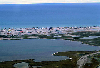
Hall Beach is an Inuit settlement within the Qikiqtaaluk Region of Nunavut, Canada, approximately 69 km (43 mi) south of Igloolik.
Cariboo River Provincial Park is a provincial park in British Columbia, Canada, located between Barkerville and Likely in the upper Cariboo River basin.
Junction Sheep Range Provincial Park is a provincial park in British Columbia, Canada, located near the confluence of the Chilcotin and Fraser Rivers on the west bank of the latter river.

Guanaqueros is a Chilean town in the commune of Coquimbo, Elqui Province, Coquimbo Region. It is located 12 kilometers from Tongoy. It is a fishermen's cove, which spreads along the eastern rim of the Cerro Guanaqueros, and with its houses built facing to the north in the direction of the Pacific Ocean.

Poncha Pass is a mountain pass in South-Central Colorado (USA). It lies between the San Luis Valley to the south and the valley of the Arkansas River to the north, and is one of the lowest mountain passes in the state. It is in the saddle between the Sangre de Cristo Range, lying to the southeast, and the Sawatch Range, lying to the west and northwest. U.S. Highway 285 runs over the pass, linking the towns of Alamosa to the south and Salida to the northeast. The small town of Poncha Springs lies about 6 miles (9 km) north of the pass. The pass has a mild approach on the northern side and a moderate 5% approach from the south, though it remains open all year round and does not normally cause problems for vehicles in winter.

Cañete de las Torres is a city located in the province of Córdoba, Spain. According to the 2006 census (INE), the city has a population of 3211 inhabitants.
Caspisapa District is one of ten districts of the province Picota in Peru.
Siemionki is a village in the administrative district of Gmina Jeziora Wielkie, within Mogilno County, Kuyavian-Pomeranian Voivodeship, in north-central Poland.
Rybne is a village in the administrative district of Gmina Gostynin, within Gostynin County, Masovian Voivodeship, in east-central Poland.

Etheda Springs is an unincorporated community in Fresno County, California. It is located 7 miles (11 km) east-southeast of Dunlap, at an elevation of 4222 feet.
The West Branch Sheepscot River is a 24.9-mile-long (40.1 km) river in Maine. The branch originates in the northwest corner of Palermo and flows southwesterly through Branch Pond and the village of Weeks Mills in the town of China. The branch then flows southerly through the town of Windsor to a confluence with the Sheepscot River between Coopers Mills and North Whitefield. The branch is bridged by Maine State Route 3 between Branch Pond and Weeks Mills, by Maine State Route 105 at Windsor and by concurrent Maine State Routes 17 and 32 near Coopers Mills.
Tubutama Municipality is a municipality in Sonora in north-western Mexico.

City of Wolverhampton College is a further education college located in Wolverhampton, West Midlands, England.
Sáng Nhè is a commune (xã) and village of the Tủa Chùa District of Điện Biên Province, northwestern Vietnam.
Amghras is a small town and rural commune in Al Haouz Province of the Marrakesh-Tensift-El Haouz region of Morocco. At the time of the 2004 census, the commune had a total population of 4222 people living in 760 households.
Konuklu is a village in the District of Ulus, Bartın Province, Turkey. As of 2010 it had a population of 223 people.

The El Salvador–Guatemala border is a 203 km international boundary in the northeast-southwest direction, northwest of El Salvador, and separating the country from the territory of Guatemala. From north to south, it starts in the triple border of the two countries with Honduras, near the peak Monte Cristo in Volcanoes National Park, extending to the southwest by the Pacific Ocean coast, following the final stage the Rio Paz. It separates the department of Jutiapa in Guatemala from Ahuachapan (north) and Santa Ana departments in El Salvador.

Elim Independent Chapel is an independent chapel in the town of Carmarthen, Carmarthenshire, Wales. The building dates from 1849 and is located about one mile north of Lime Grove House, Carmarthen. The chapel was designated a Grade II listed building on 19 May 1981.
Trerhyngyll is a small village in the Vale of Glamorgan, about 2 miles (3.2 km) north of Cowbridge and 1 mile (1.6 km) south of Ystradowen, near Maendy, off the A4222 road. Trerhyngyll and Maendy Halt railway station operated here from 1905 to 1951, though the line was closed to passengers as early as 1930 between Cowbridge and Aberthaw. In 1986 it was described as a "typical vale village with between 50-60 houses, most of which are 10-50 years old though 8 are over 200 years old." Trerhyngyll typically houses commuters who work in Cowbridge or Cardiff.

NGC 4222 is an edge-on spiral galaxy located about 60 million light-years away in the constellation Coma Berenices. It was discovered by astronomer William Herschel on April 8, 1784 and is often misidentified as IC 3087. NGC 4222 is a member of the Virgo Cluster and is a companion of NGC 4216 which lies about 180,000 ly (56 kpc) away. Despite this, the two galaxies are not interacting.