Oriskany is a village in Oneida County, New York, United States. The population was 1,400 at the 2010 census. The name is derived from the Iroquois word for "nettles."

The qathet Regional District is a regional district in the Canadian province of British Columbia. It includes the City of Powell River and a number of unincorporated areas. The district encompasses a land area of 5,092.06 square kilometres (1,966.06 sq mi). Formerly known as the formerly the Powell River Regional District, its name was changed in 2018 to qathet, meaning "working together" in the language of the Tla'amin Nation.
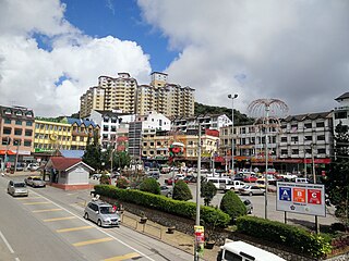
Brinchang is a town and hill resort located at an altitude of 1,540 metres (5,050 ft) in Cameron Highlands in the state of Pahang, Malaysia.
Woodside Green is an area and street located in Woodside, London, centred on a village green. The station is located near to Woodside tram stop in the London Borough of Croydon. The green is over 4.75 acres (1.92 ha).

Crime Classification Manual: A Standard System for Investigating and Classifying Violent Crimes (1992) is a text on the classification of violent crimes by John E. Douglas, Ann W. Burgess, Allen G. Burgess and Robert K. Ressler. The publication is a result of a project by the Federal Bureau of Investigation's National Center for the Analysis of Violent Crime.
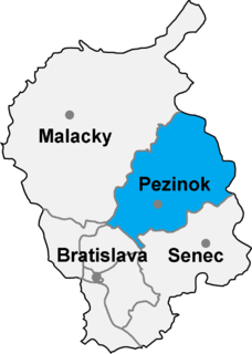
Píla is a village and municipality in western Slovakia in Pezinok District in the Bratislava region.

Park West is a large business park within west Dublin, Ireland, notable for its public art and with some residential development. Over 300 companies, with over 10,000 employees, are based there.

Sal-like protein 2 is a protein that in humans is encoded by the SALL2 gene.
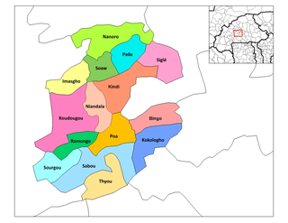
Tabalosos District is one of eleven districts of the province Lamas in Peru.
Rudnica is a village in the administrative district of Gmina Wałcz, within Wałcz County, West Pomeranian Voivodeship, in north-western Poland. Main tourist attraction within Rudnica is Rudnica Park Linowy, second largest of its type in Poland.
Wójcin A is a village in the administrative district of Gmina Paradyż, within Opoczno County, Łódź Voivodeship, in central Poland.

Shipaiqiao Station is a station of Line 3 of the Guangzhou Metro. It started operations on 30 December 2006. It is located in Tianhe District, underneath Tianhe Road between East Tianhe Road and East Tiyu Road.

Cedar Vista is an unincorporated community in Calaveras County, California. It lies at an elevation of 3317 feet. Cedar Vista is located at 38°10′10″N120°24′29″W.
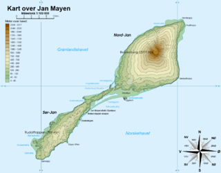
Gouwenaerbåen is a 10 m (33 ft) shoal or reef southeast of Eggøya, on the southern coast of the island of Jan Mayen. It is named after the Dutch seafarer Jacob de Gouwenaer, who was master of the Orangienboom in 1614, when he had first come upon the island. His name had originally been attached to Rekvedbukta.
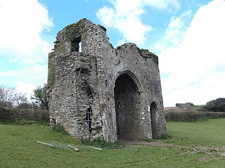
Cornworthy Priory was a priory in Devon, England. It was founded in the early thirteenth century, for Augustinian nuns, and existed until 1536. At the Dissolution of the Monasteries the lands passed to the Harris family, and remained in the family until the 1640s. Thomas Harris who was a Serjeant-at-Law lived here with his wife Elizabeth. Their daughter, Anne, Lady Southwell, who was a noted poet, was born here.

Solute carrier family 12 member 9 (SLC12A9), also known as cation-chloride cotransporter 6 (CCC6) or cation-chloride cotransporter-interacting protein 1 (CIP1), is a protein that in humans is encoded by the SLC12A9 gene.
Side, Manavgat is a village in the District of Manavgat, Antalya Province, Turkey.

Edith Gardens is a 0.44 hectare Local Nature Reserve and Site of Local Importance for Nature Conservation in Berrylands in the Royal Borough of Kingston upon Thames in London. It was designated in 1992.
V.R. Eaton High School is a high school located in far northern Fort Worth, Texas, with a Haslet mailing address. It is a part of the Northwest Independent School District.
Grant Township is an inactive township in Webster County, in the U.S. state of Missouri.