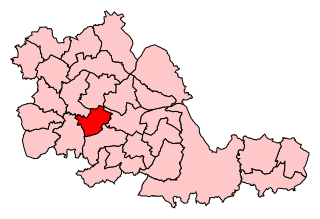
Warley is a constituency in the House of Commons of the UK Parliament. The constituency was established in 1997, and has been represented since that date by John Spellar, a member of the Labour Party.

The Browns Lane plant in Coventry, England was built as a Second World War shadow factory run by The Daimler Company Limited. In 1951 it was leased by Jaguar Cars and remained the company's home until 2005. It was the site of all Jaguar production until 1998, when production of the Jaguar S-Type commenced at Castle Bromwich. It was also the firm's corporate headquarters and the home of the Jaguar Daimler Heritage Trust.
Midland Mills is a former flax mill on Silver Street in Holbeck, Leeds, West Yorkshire, in the Holbeck Urban Village regeneration area. Since the 1980s it has been used for light industrial work.
Man flu is a phrase that refers to the idea that men, when they have a common cold, experience and self-report symptoms of greater severity, akin to those experienced during the flu. While a commonly-used phrase in much of the English speaking world, there is a continuing discussion over the scientific basis.

Sandygate Road is a football and cricket stadium in the Sheffield suburb of Crosspool, South Yorkshire, England. It is home to Hallam F.C. and Hallam C.C.

Zinc transporter ZIP1 is a protein that in humans is encoded by the SLC39A1 gene.

Zinc transporter ZIP2 is a protein that in humans is encoded by the SLC39A2 gene.

Zinc transporter ZIP3 is a protein that in humans is encoded by the SLC39A3 gene.

The Owen Fracture Zone (OFZ), though misnamed a fracture zone, is a transform fault in the northwest Indian Ocean that separates the Arabian and African Plates from the Indian Plate. Extending north-northeast from where the Carlsberg Ridge meets the Sheba ridge in the south to the Makran Subduction Zone in the north, it represents the port side of the northward motion of the Indian subcontinent during the Late Cretaceous–Palaeogene break-up of Gondwana. Slip along the Owen Fracture Zone is occurring at 2 mm (0.079 in)/yr, the slowest rate on Earth, which means the Arabian Plate moves northward faster than the Indian Plate.

The Roman Catholic Archdiocese of Taiyuan is an archdiocese located in the city of Taiyuan in China.
Waddington railway station was a station in Waddington, Lincolnshire which closed on 10 September 1962 but the line through the station remained open until 1965.
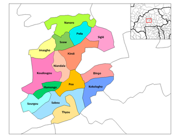
Séguédin is a town in the Soaw Department of Boulkiemdé Province in central western Burkina Faso. It has a population of 2,802.

Maksim Bahdanovič Literary Museum is a museum in Minsk, Belarus. It is dedicated to the writer Maksim Bahdanovič (1891–1917).

Ahmedabad University is a private, non-profit university set up in 2009 by the Ahmedabad Education Society. It comprises four schools and four centres with opportunities for interdisciplinary scholarship. Ahmedabad University offers students a liberal education focused on research and interdisciplinary learning.

The Portland Cenotaph is a war memorial located on the Isle of Portland, Dorset, England. It is situated at New Ground, looking down to Underhill of the island and overlooking Chesil Beach, as it sits in front of Portland Heights Hotel. The monument is dedicated to the local soldiers who died during both the First and Second World Wars. It has been a Grade II Listed Monument since May 1993.
Fryingpan Canyon, a valley in the Cookes Range, in Luna County, New Mexico. Its mouth lies at 4715 feet (1437m), at its confluence with Starvation Draw. Its source lies at 5560 feet, at 32°28′50″N107°41′28″W, in the Cookes Range, on the east slope of Rattlesnake Ridge at its eastern end.
Wild Turkey Strand Preserve is a 3,137 acre area of protected lands in Lee County, Florida. The preserve is off State Route south of Lehigh Acres. It includes part of the former Buckingham Army Airfield, a World War II-era training base.
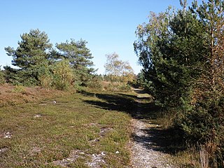
Ideford Common is a Site of Special Scientific Interest consisting of an area of lowland heath in Devon, England. The site is a habitat for nightjars and Dartford warblers, and is the site of several Bronze Age cairns and a barrow.
Tijeras is a corregimiento in Boquerón District, Chiriquí Province, Panama. It has a land area of 17.5 square kilometres (6.8 sq mi) and had a population of 2,670 as of 2010, giving it a population density of 152.2 inhabitants per square kilometre (394/sq mi). Its population as of 1990 was 1,341; its population as of 2000 was 2,057.