Sourgou Department

Last updated
Sourgou
Department
Boulkiemde departments.png
Sourgou Department location in the province
Country Flag of Burkina Faso.svg  Burkina Faso
Province Boulkiemdé Province
Population (2005)
  Total 13,878
Time zone GMT 0 (UTC+0)

Sourgou is a department or commune of Boulkiemdé Province in central Burkina Faso. As of 2005 it has a population of 13,878. Its capital lies at the town of Sourgou. [1]

Departments of Burkina Faso administrative division and commune of Burkina Faso

The provinces of Burkina Faso are divided into 351 departments, whose urbanized areas are grouped into the same commune (municipality) with the same name as the department. The 351 communes created in those departments have three kinds of status :

Boulkiemdé Province Province in Centre-Ouest Region, Burkina Faso

Boulkiemdé is one of the 45 provinces of Burkina Faso and is in Centre-Ouest Region. The capital of Boulkiemdé is Koudougou. The population of Boulkiemdé was 498,008 in 2006 and 567,680 in 2011.

Burkina Faso country in Africa

Burkina Faso is a landlocked country in West Africa. It covers an area of around 274,200 square kilometres (105,900 sq mi) and is surrounded by six countries: Mali to the north; Niger to the east; Benin to the southeast; Togo and Ghana to the south; and Ivory Coast to the southwest. The July 2018 population estimate by the United Nations was 19,751,651. Burkina Faso is a francophone country, with French as the official language of government and business. Roughly 40% of the population speaks the Mossi language. Formerly called the Republic of Upper Volta (1958–1984), the country was renamed "Burkina Faso" on 4 August 1984 by then-President Thomas Sankara. Its citizens are known as Burkinabé. Its capital is Ouagadougou.

Towns and villages

 · Sourgou  · Guirgo  · Kougsin  ·  · Ouoro  · Rogho

Sourgou Place in Centre-Ouest Region, Burkina Faso

Sourgou is a town in the Sourgou Department of Boulkiemdé Province in central western Burkina Faso. It is the capital of the Sourgou Department and has a population of 2,211.

Guirgo, Boulkiemdé Place in Centre-Ouest Region, Burkina Faso

Guirgo, Boulkiemdé is a town in the Sourgou Department of Boulkiemdé Province in central western Burkina Faso. It has a population of 1,384.

Kougsin Place in Centre-Ouest Region, Burkina Faso

Kougsin is a town in the Sourgou Department of Boulkiemdé Province in central western Burkina Faso. It has a population of 1,649.

Related Research Articles

Geography of France

The geography of France consists of a terrain that is mostly flat plains or gently rolling hills in the north and west and mountainous in the south and the east.

Arctic Archipelago Canadian archipelago

The Arctic Archipelago, also known as the Canadian Arctic Archipelago, is a group of islands north of the Canadian mainland.

In number theory, a lucky number is a natural number in a set which is generated by a certain "sieve". This sieve is similar to the Sieve of Eratosthenes that generates the primes, but it eliminates numbers based on their position in the remaining set, instead of their value.

This is a list of the extreme points of Ireland – the points that are farthest north, south, east or west in Ireland. It includes the Republic of Ireland and Northern Ireland.

Charlotte Parish, Saint Vincent and the Grenadines Parish in Georgetown, Saint Vincent and the Grenadines

Charlotte is the largest parish of Saint Vincent and the Grenadines, situated on the eastern coast of the island of Saint Vincent. With an area of 149 km², its size is comparable to that of the British Virgin Islands.) The parish has the longest coastline of all the parishes and is also larger than the three smallest parishes combined. The parish possesses a very rough and rugged topography with very little flat land occurring towards the coast. as a result of these features, parts of the north of the parish cannot be accessed by a main road. Up until the building of a bridge over the Rabacca Dry River access to the north side of the river was not possible when rain caused the river to swell and make the path impassable.

Grenadines Parish Parish in Port Elizabeth, Saint Vincent and the Grenadines

Grenadines is an administrative parish of Saint Vincent and the Grenadines. Its capital is Port Elizabeth.

Sherwood, Prince Edward Island human settlement in Canada

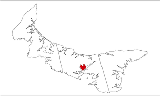
Sherwood is a neighbourhood of the city of Charlottetown in central Queens County, Prince Edward Island, Canada.

Nava del Barco municipality in Castile and León, Spain

Nava del Barco is a municipality located in the province of Ávila, Castile and León, Spain. According to the 2006 census (INE), the municipality has a population of 133 inhabitants.

Moussakongo is a town in the Solenzo Department of Banwa Province in western Burkina Faso. As of 2005 it had a population of 3,310.
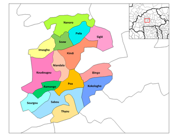
Lâ Place in Centre-Ouest Region, Burkina Faso

is a town in the Sourgou Department of Boulkiemdé Province in central western Burkina Faso. It has a population of 2,180.

Rogho Place in Centre-Ouest Region, Burkina Faso

Rogho is a town in the Sourgou Department of Boulkiemdé Province in central western Burkina Faso. It has a population of 2,935.

Voineasa, Olt Commune in Olt County, Romania

Voineasa is a commune in Olt County, Romania. It is composed of five villages: Blaj, Mărgăritești, Racovița, Rusăneștii de Sus and Voineasa.

Yoro is a village and commune and seat of the Cercle of Koro in the Mopti Region of Mali. In 1998 the commune had a population of 10,535.

Žehuň is a village and municipality in Kolín District in the Central Bohemian Region of the Czech Republic.

Viidu is a village in Saaremaa Parish, Saare County in western Estonia.

Extreme points of Bhutan

This is a list of the extreme points of Bhutan.

German submarine U-283 was a Type VIIC U-boat of Nazi Germany's Kriegsmarine during World War II.

Niakaramandougou Department Department in Vallée du Bandama, Ivory Coast

Niakaramandougou Department is a department of Hambol Region in Vallée du Bandama District, Ivory Coast. In 2014, its population was 133,818 and its seat is the settlement of Niakaramandougou. The sub-prefectures of the department are Arikokaha, Badikaha, Niakaramandougou, Niédiékaha, Tafiré, and Tortiya.

References

Coordinates: 12°08′N2°17′W / 12.133°N 2.283°W / 12.133; -2.283

Geographic coordinate system Coordinate system

A geographic coordinate system is a coordinate system that enables every location on Earth to be specified by a set of numbers, letters or symbols. The coordinates are often chosen such that one of the numbers represents a vertical position and two or three of the numbers represent a horizontal position; alternatively, a geographic position may be expressed in a combined three-dimensional Cartesian vector. A common choice of coordinates is latitude, longitude and elevation. To specify a location on a plane requires a map projection.