Imasgho Department

Last updated
Imasgho
Department
Boulkiemde departments.png
Imasgho Department location in the province
Country Flag of Burkina Faso.svg  Burkina Faso
Province Boulkiemdé Province
Population (2005)
  Total 24,106
Time zone GMT 0 (UTC+0)

Imasgho is a department or commune of Boulkiemdé Province in central Burkina Faso. As of 2005, it had a population of 24,106. Its capital lies at the town of Imasgho. [1]

Departments of Burkina Faso administrative division and commune of Burkina Faso

The provinces of Burkina Faso are divided into 351 departments, whose urbanized areas are grouped into the same commune (municipality) with the same name as the department. The 351 communes created in those departments have three kinds of status :

Boulkiemdé Province Province in Centre-Ouest Region, Burkina Faso

Boulkiemdé is one of the 45 provinces of Burkina Faso and is in Centre-Ouest Region. The capital of Boulkiemdé is Koudougou. The population of Boulkiemdé was 498,008 in 2006 and 567,680 in 2011.

Burkina Faso country in Africa

Burkina Faso is a landlocked country in West Africa. It covers an area of around 274,200 square kilometres (105,900 sq mi) and is surrounded by six countries: Mali to the north; Niger to the east; Benin to the southeast; Togo and Ghana to the south; and Ivory Coast to the southwest. The July 2018 population estimate by the United Nations was 19,751,651. Burkina Faso is a francophone country, with French as the official language of government and business. Roughly 40% of the population speaks the Mossi language. Formerly called the Republic of Upper Volta (1958–1984), the country was renamed "Burkina Faso" on 4 August 1984 by then-President Thomas Sankara. Its citizens are known as Burkinabé. Its capital is Ouagadougou.

Towns and villages

 · Imasgho  · Danierma  · Kanyalé  · Lounga  · Ouéra  · Rana

Imasgho town in Centre-Ouest Region, Burkina Faso

Imasgho is a town in the Imasgho Department of Boulkiemdé Province in central western Burkina Faso. It is the capital of the Imasgho Department and has a population of 12,031.

Danierma is a town in the Imasgho Department of Boulkiemdé Province in central western Burkina Faso. It has a population of 2,459.

Kanyalé is a town in the Imasgho Department of Boulkiemdé Province in central western Burkina Faso. It has a population of 1,954.

Related Research Articles

Arctic Archipelago Canadian archipelago

The Arctic Archipelago, also known as the Canadian Arctic Archipelago, is a group of islands north of the Canadian mainland.

Mid-Atlantic Ridge A divergent tectonic plate boundary that in the North Atlantic separates the Eurasian and North American plates, and in the South Atlantic separates the African and South American plates

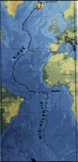
The Mid-Atlantic Ridge (MAR) is a mid-ocean ridge, a divergent tectonic plate or constructive plate boundary located along the floor of the Atlantic Ocean, and part of the longest mountain range in the world. In the North Atlantic it separates the Eurasian and North American plates, and in the South Atlantic it separates the African and South American plates. The ridge extends from a junction with the Gakkel Ridge northeast of Greenland southward to the Bouvet Triple Junction in the South Atlantic. Although the Mid-Atlantic Ridge is mostly an underwater feature, portions of it have enough elevation to extend above sea level. The section of the ridge that includes Iceland is known as the Reykjanes Ridge. The ridge has an average spreading rate of about 2.5 centimetres (0.98 in) per year.

Grenadines Parish Parish in Port Elizabeth, Saint Vincent and the Grenadines

Grenadines is an administrative parish of Saint Vincent and the Grenadines, comprising the islands of the Grenadines other than those belonging to Grenada. The capital is Port Elizabeth.

Woodhaven, Fife a town in Fife, United Kindom

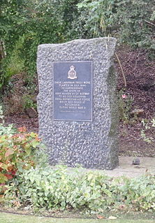
Woodhaven used to be a small village between Newport-on-Tay and Wormit in Fife, Scotland. Due to expansion of these two villages over the years, it is now just the name for a harbour and pier . During World War II there was a flying boat station at Woodhaven operating four PBY5 Catalina aircraft manned by Flight A of 333 Squadron Royal Norwegian Air Force. The Norwegian personnel were based at RAF Leuchars along with their colleagues in Flight B who flew land based Mosquito aircraft.

San Joaquin, Corozal Place in Corozal District, Belize

San Joaquin is a village in the Corozal District of Belize. With a population of about 2000 people, it is one of the largest villages in Corozal. The town was formed as a result of Mestizos migrating to escape the 1847–1901 Caste War of Yucatán.

Dragalina, Călărași Place in Călărași County, Romania

Dragalina is a commune in Călărași County, Romania, named after the Romanian general Ion Dragalina. It is composed of three villages: Constantin Brâncoveanu, Dragalina and Drajna Nouă.

Tobgyai is a village and township in the Tibet Autonomous Region of China.

Kindi Department Department in Boulkiemdé Province, Burkina Faso

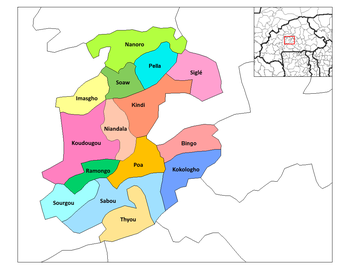
Kindi is a department or commune of Boulkiemdé Province in central Burkina Faso. As of 2005 it had a population of 13,033. Its capital lies at the town of Kindi.

Loungo is a village in the Sabce Department of Bam Province in northern-central Burkina Faso. It has a population of 723.

Rana, Burkina Faso is a town in the Imasgho Department of Boulkiemdé Province in central western Burkina Faso. It has a population of 2,854.

Kakhay Place in Agdash, Azerbaijan

Kakhay is a village in the Agdash Rayon of Azerbaijan.

This is a list of the extreme points and extreme elevations in Wales.

Tatary, Nidzica County Village in Warmian-Masurian, Poland

Tatary is a village in the administrative district of Gmina Nidzica, within Nidzica County, Warmian-Masurian Voivodeship, in northern Poland. It lies approximately 3 kilometres (2 mi) south of Nidzica and 51 km (32 mi) south of the regional capital Olsztyn.

Irase is a village in Saaremaa Parish, Saare County in western Estonia.

Enandio is located in the Juárez Municipality, Michoacán, two miles before arriving at Los Laureles, Michoacán.

Parthenina interstincta is a rather widely distributed species of sea snail, a marine gastropod mollusk in the family Pyramidellidae, the pyrams and their allies.

North Danger Reef is one of the seven major reefs / banks / etc. in the Spratly Islands area of the South China Sea. It is the most North Western of the features of the Spratly Islands, located to the NW of Dangerous Ground.

References

Coordinates: 12°26′N2°20′W / 12.433°N 2.333°W / 12.433; -2.333

Geographic coordinate system Coordinate system

A geographic coordinate system is a coordinate system that enables every location on Earth to be specified by a set of numbers, letters or symbols. The coordinates are often chosen such that one of the numbers represents a vertical position and two or three of the numbers represent a horizontal position; alternatively, a geographic position may be expressed in a combined three-dimensional Cartesian vector. A common choice of coordinates is latitude, longitude and elevation. To specify a location on a plane requires a map projection.