Nanoro Department

Last updated
Nanoro
Department
Boulkiemde departments.png
Nanoro Department location in the province
Country Flag of Burkina Faso.svg  Burkina Faso
Province Boulkiemdé Province
Population (2005)
  Total 33,511
Time zone GMT 0 (UTC+0)

Nanoro is a department or commune of Boulkiemdé Province in central Burkina Faso. As of 2005 it has a population of 33,511. Its capital lies at the town of Nanoro. [1]

Departments of Burkina Faso administrative division and commune of Burkina Faso

The provinces of Burkina Faso are divided into 351 departments, whose urbanized areas are grouped into the same commune (municipality) with the same name as the department. The 351 communes created in those departments have three kinds of status :

Boulkiemdé Province Province in Centre-Ouest Region, Burkina Faso

Boulkiemdé is one of the 45 provinces of Burkina Faso and is in Centre-Ouest Region. The capital of Boulkiemdé is Koudougou. The population of Boulkiemdé was 498,008 in 2006 and 567,680 in 2011.

Burkina Faso country in Africa

Burkina Faso is a landlocked country in West Africa. It covers an area of around 274,200 square kilometres (105,900 sq mi) and is surrounded by six countries: Mali to the north; Niger to the east; Benin to the southeast; Togo and Ghana to the south; and Ivory Coast to the southwest. The July 2018 population estimate by the United Nations was 19,751,651. Burkina Faso is a francophone country, with French as the official language of government and business. Roughly 40% of the population speaks the Mossi language. Formerly called the Republic of Upper Volta (1958–1984), the country was renamed "Burkina Faso" on 4 August 1984 by then-President Thomas Sankara. Its citizens are known as Burkinabé. Its capital is Ouagadougou.

Towns and villages

 · Nanoro  · Basziri  · Boulpon  · Dacissé  · Godo  · Goulouré  · Gouroumbila  · Kokolo  · Nazoanga  · Poéssi  · Séguédin  · Sittaon  · Soala  · Soum  · Simidin

Nanoro Place in Centre-Ouest Region, Burkina Faso

Nanoro is a town in the Nanoro Department of Boulkiemdé Province in central western Burkina Faso. It is the capital of Nanoro Department and has a population of 5,234.

Basziri, Nanoro Place in Centre-Ouest Region, Burkina Faso

Basziri, Nanoro is a village in the Nanoro Department of Boulkiemdé Province in central western Burkina Faso. It has a population of 791.

Boulpon Place in Centre-Ouest Region, Burkina Faso

Boulpon is a town in the Nanoro Department of Boulkiemdé Province in central western Burkina Faso. It has a population of 4,431.

Related Research Articles

Socastee, South Carolina CDP in South Carolina, United States

Socastee is a census-designated place (CDP) in Horry County, South Carolina, United States. The population was 19,952 at the 2010 census.

Cuautitlán Town & Municipality in State of Mexico, Mexico

Cuautitlán is a city and municipality in the State of Mexico, just north of the northern tip of the Federal District within the Greater Mexico City urban area. The city has engulfed most of the municipality, making the two synonymous. The name comes from Nahuatl and means 'between the trees.'

Grenadines Parish Parish in Port Elizabeth, Saint Vincent and the Grenadines

Grenadines is an administrative parish of Saint Vincent and the Grenadines, comprising the islands of the Grenadines other than those belonging to Grenada. The capital is Port Elizabeth.

Revúcka Lehota municipality of Slovakia

Revúcka Lehota is a village and municipality in Revúca District in the Banská Bystrica Region of Slovakia.

Guarromán is a city located in the province of Jaén, Spain. According to the 2006 census (INE), the city has a population of 2904 inhabitants.

Cogollos municipality in Castile and León, Spain

Cogollos is a municipality located in the province of Burgos, Castile and León, Spain. According to the 2004 census (INE), the municipality has a population of 348 inhabitants.

Almenar de Soria Place in Castile and León, Spain

Almenar de Soria is a municipality located in the province of Soria, Castile and León, Spain. According to the 2004 census (INE), the municipality has a population of 342 inhabitants.

Solenzo Department Department in Banwa Province, Burkina Faso

Solenzo is a department or commune of Banwa Province in western Burkina Faso. Its capital lies at the town of Solenzo. According to the 1996 census the department has a total population of 115,927.

Crețeni Commune in Vâlcea County, Romania

Crețeni is a commune located in Vâlcea County, Romania. It is composed of four villages: Crețeni, Izvoru, Mrenești and Streminoasa.

LZ 13 Hansa

The Zeppelin LZ 13 Hansa was a German civilian rigid airship first flown in 1912. It was built for DELAG to carry passengers and post and flew the first international passenger flight, visiting Denmark and Sweden in September 1912. In 1913 it was hired to the Imperial German Navy as a training craft, and at the outbreak of World War I it was requisitioned by the German military who used it for bombing, reconnaissance, and finally as a training airship.

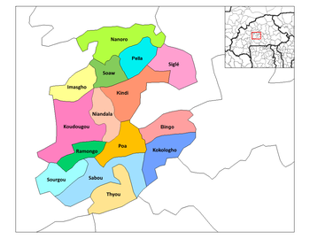
Dacissé is a town in the Nanoro Department of Boulkiemdé Province in central western Burkina Faso. It has a population of 2,070.

Goulouré, Nanoro is a town in the Nanoro Department of Boulkiemdé Province in central western Burkina Faso. It has a population of 1,216.

Gyalmya Place in Aghjabadi, Azerbaijan

Gyalmya is a village in the Aghjabadi Rayon of Azerbaijan.

Wólka Jagielczyńska Village in Łódź, Poland

Wólka Jagielczyńska is a village in the administrative district of Gmina Czerniewice, within Tomaszów Mazowiecki County, Łódź Voivodeship, in central Poland. It lies approximately 4 kilometres (2 mi) north-east of Czerniewice, 22 km (14 mi) north-east of Tomaszów Mazowiecki, and 51 km (32 mi) east of the regional capital Łódź.

The Kaituma River is a river of Guyana.

Sajólászlófalva is a village in Borsod-Abaúj-Zemplén County in northeastern Hungary.

Torremontalbo is a municipality in the province and autonomous community of La Rioja, Spain, situated at the foot of the N-232 road (Spain). The municipality covers an area of 8.07 square kilometres (3.12 sq mi) and as of 2011 had a population of 14 people.

Kurtkayı is a village in the District of Kastamonu, Kastamonu Province, Turkey.

References

Coordinates: 12°41′N2°11′W / 12.683°N 2.183°W / 12.683; -2.183

Geographic coordinate system Coordinate system

A geographic coordinate system is a coordinate system that enables every location on Earth to be specified by a set of numbers, letters or symbols. The coordinates are often chosen such that one of the numbers represents a vertical position and two or three of the numbers represent a horizontal position; alternatively, a geographic position may be expressed in a combined three-dimensional Cartesian vector. A common choice of coordinates is latitude, longitude and elevation. To specify a location on a plane requires a map projection.