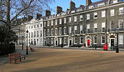
Bloomsbury is a district in the West End of London, part of the London Borough of Camden in England. It is considered a fashionable residential area, and is the location of numerous cultural, intellectual, and educational institutions. Bloomsbury is home of the British Museum, the largest museum in the United Kingdom, and several educational institutions, including University College London and a number of other colleges and institutes of the University of London as well as its central headquarters, the New College of the Humanities, the University of Law, the Royal Academy of Dramatic Art, the British Medical Association and many others. Bloomsbury is an intellectual and literary hub for London, as home of world-known Bloomsbury Publishing, publishers of the Harry Potter series, and namesake of the Bloomsbury Group, a group of British intellectuals which included author Virginia Woolf, biographer Lytton Strachey, and economist John Maynard Keynes.

Highgate is a suburban area of London at the northeastern corner of Hampstead Heath, 4+1⁄2 miles north-northwest of Charing Cross.

Holborn, an area in central London, covers the south-eastern part of the London Borough of Camden and a part of the Ward of Farringdon Without in the City of London.
The Metropolitan Borough of Holborn was a metropolitan borough in the County of London between 1900 and 1965. The borough included most of Holborn as well as Bloomsbury and St Giles.

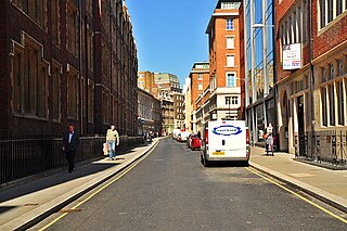
Hatton Garden is a street and commercial zone in the Holborn district of the London Borough of Camden, abutting the narrow precinct of Saffron Hill which then abuts the City of London. It takes its name from Sir Christopher Hatton, a favourite of Queen Elizabeth I, who established a mansion here and gained possession of the garden and orchard of Ely Place, the London seat of the Bishops of Ely. It remained in the Hatton family and was built up as a stylish residential development in the reign of King Charles II. For some decades it often went, outside of the main street, by an alternative name St Alban's Holborn, after the local church built in 1861.

The Royal Free Hospital is a major teaching hospital in the Hampstead area of the London Borough of Camden. The hospital is part of the Royal Free London NHS Foundation Trust, which also runs services at Barnet Hospital, Chase Farm Hospital and a number of other sites. The trust is a founder member of the UCLPartners academic health science centre.
The WC postcode area, also known as the London WC postcode area, is a group of postcode districts in central London, England. The area covered is of high density development, and includes parts of the City of Westminster and the London Boroughs of Camden and Islington, plus a very small part of the City of London.
Portpool was a manor or soke in the district of Holborn, London. It is not recorded in the Domesday Book but references to it occur from the 12th century onwards. For many years it was owned by the Dean and Chapter of St Paul's Cathedral, who let it out to the Grey family. The manor house of Portpool subsequently became known as Gray's Inn, acquiring a reputation for the teaching of law.

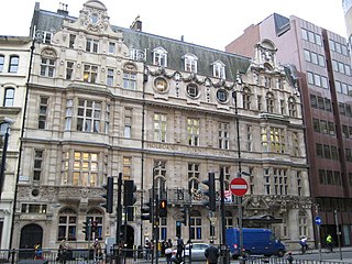
The Royal National Throat, Nose and Ear Hospital was a health facility on Gray's Inn Road in London. It closed in October 2019 when services transferred to the new Royal National ENT and Eastman Dental Hospitals on Huntley Street, London, WC1E 6DG. The Huntley Street hospital continues to provide specialist ENT, sleeps and allergy services and is part of University College London Hospitals NHS Foundation Trust.

The Bourne Estate is an Edwardian housing estate in Holborn, located in the London Borough of Camden. It is bounded by Clerkenwell Road to the north, Gray's Inn Road to the west, Leather Lane to the east and Baldwins Gardens to the south. It is also intersected by Portpool Lane, which forms part of the estate itself.
Chancery Lane is a one-way street that forms part of the western boundary of the City of London. The east side of the street is entirely within the City, whilst the west side is in the City of Westminster south of Carey Street and the London Borough of Camden north of that street. The route originated as a 'new lane' created by the Knights Templar from their original 'old Temple' on the site of the present Southampton Buildings on Holborn, in order to access to their newly acquired property to the south of Fleet Street sometime before 1161.

St David's School was an independent girls' school in Ashford, England. The school was originally established in London in 1716 as the British Charity School or Welsh Charity School. It was located in a purpose-built home on Clerkenwell Green from 1738, before moving to Gray's Inn Road in 1772, and eventually to Ashford in 1857. It was at first a boys' school, and then from 1758 co-educational, but from 1882 it began to admit girls only and became known as the Welsh Girls' School. It changed its name to St David's School in 1967, and closed in 2009.

The Eastman Dental Hospital was based on Gray's Inn Road until it co-located with the University College London ear, nose, throat, balance and hearing services on Huntley Street, London, as the Royal National ENT and Eastman Dental Hospitals in October 2019. The hospital continues to provide specialist dental treatment as well as ear, nose, throat, hearing, speech and balance services and is part of the University College London Hospitals NHS Foundation Trust.
University College London Hospitals NHS Foundation Trust (UCLH) is an NHS foundation trust based in London, United Kingdom. It comprises University College Hospital, University College Hospital at Westmoreland Street, the UCH Macmillan Cancer Centre, the Royal National ENT and Eastman Dental Hospitals, the Hospital for Tropical Diseases, the National Hospital for Neurology and Neurosurgery, the Royal London Hospital for Integrated Medicine and the Royal National Throat, Nose and Ear Hospital.
Thavie's Inn was a former Inn of Chancery, associated with Lincoln's Inn, established at Holborn, near the site of the present side street and office block still known as Thavies Inn Buildings. Thavie's Inn is one of the earliest Inns of Chancery on record, both by date of establishment and dissolution. It remains a well-known City of London landmark, where Lloyd's Bank is situated, on the opposite side of Holborn Circus from Ely Place.

The London Borough of Camden is a London borough in Inner London, England. Camden Town Hall, on Euston Road, lies 1.4 mi (2.3 km) north of Charing Cross. The borough was established on 1 April 1965 and includes the former Central London borough of Holborn, and St Pancras and Hampstead.
Hugh Denys of Osterley in Middlesex, was a courtier of Kings Henry VII and of the young Henry VIII. As Groom of the Stool to Henry VII, he was one of the King's closest courtiers, his role developing into one of administering the Privy Chamber, a department in control of the royal finances which during Denys's tenure of office also gained control over national fiscal policy. Denys was thus a vital player in facilitating the first Tudor king's controversial fiscal policies.

The London Welsh Centre is a community and arts centre on Gray's Inn Road, in the London Borough of Camden. The centre is owned and run by the London Welsh Trust.
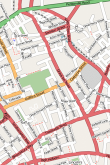
This is a list of the etymology of street names in the London district of Holborn. Holborn has no formally defined boundaries - those utilised here are: Theobald’s Road to the north, Gray's Inn Road and the City of London boundary to the east, Victoria Embankment/the Thames to the south, and Lancaster Place, the north-west curve of the Aldwych semi-circle, Kingsway/Southampton Row to the west.