There are three houses named the Harrison Gray Otis House in Boston, Massachusetts. All were built by noted American architect Charles Bulfinch for the same man, Federalist lawyer and politician Harrison Gray Otis.

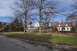
The West Newton Hill NR Historic District is a residential National Register historic district in the village of West Newton, in the city of Newton, Massachusetts in the United States. It is composed of a cohesive collection of spacious houses built in the second half of the 19th century, representing the development of the West Newton area as a fashionable railroad suburb. The district was listed on the National Register of Historic Places in 1986.

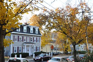
The Berkeley Street Historic District is a historic district on Berkeley Street and Berkeley Place in Cambridge, Massachusetts. It encompasses a neighborhood containing one of the greatest concentrations of fine Italianate and Second Empire houses in the city. It was listed on the National Register of Historic Places in 1982, with a substantial increase in 1986.

The East Cambridge Historic District encompasses the historic center of East Cambridge, Massachusetts. It includes the major buildings that were built to house county services for Middlesex County beginning in the 1810s, and a cluster of largely vernacular Greek Revival worker housing located west of the county complex on Otis, Thorndike, Spring, and Sciarappa Streets. The district was listed on the National Register of Historic Places in 1983.

Hall Tavern is an historic tavern at 20 Gray Gardens West Street in Cambridge, Massachusetts. Now converted to residential use, this two story Federal style wood-frame building was built in sometime in the late 1790s in Duxbury, Massachusetts, and was moved to this location in 1930. The building is one of a number that were moved in order to preserve them in the early decades of the 20th century, and it is now one of the centerpieces of the Gray Gardens subdivision.

The Old Douglas Center Historic District encompasses the historic heart of Douglas, Massachusetts. The historic district radiates away from the town common, and is bounded by farmlands and more recent 20th-century development. There are 50 contributing resources in the 192-acre (78 ha) district. Most of the structures are residential houses in Federal and Greek Revival styles. There are a number of institutional buildings, including the 1834 Greek Revival First Congregational Church, the Craftsman-style Douglas Pastime Club building at 22 Church Street, and the c. 1770s Dudley Tavern. The town common and the adjacent Center Cemetery, laid out when the town was incorporated in 1746, are at the center of the district.

The South Lee Historic District encompasses the historic portion of the village of South Lee in Lee, Massachusetts. Extending mainly along Massachusetts Route 102 between Fairview Street and the Stockbridge town line, the village is a well-preserved 19th-century mill village, with fine Federal and Greek Revival buildings and a later 19th-century paper mill. It was listed on the National Register of Historic Places in 1999.

The Tavern Acres Historic District encompasses a residential development known as Tavern Acres, which was built in the 1920s with a landscape design by Henry Vincent Hubbard, then with the Olmsted Brothers landscape design firm. It is bounded by Bradstreet Rd., Green and Main Sts. and Park Way in North Andover, Massachusetts. The district encompasses Memorial Park, the Stevens Library, and properties facing Memorial Park and further along Bradstreet Road. The district was listed on the National Register of Historic Places in 1995.

The Kensington Park Historic District of Arlington, Massachusetts encompasses a turn of the 20th century planned residential subdivision in the hills above the town center, representing an early phase in the town's transition from a rural to suburban setting. The district consists of most of the houses on Brantwood and Kensington Roads, which wind around a rocky hillside overlooking Pleasant Street and Spy Pond, just west of the center. A number of the houses are the work of architect C. Herbert McClare, who also lived in the area, and was one of the development's proponents. The district was listed on the National Register of Historic Places in 1985.

The Wedgemere Historic District encompasses the largest single 19th-century residential development of Winchester, Massachusetts. It is one of the town's largest surviving 19th-century residential subdivisions, with a concentration of high-quality residences built between about 1890 and 1920. The district was listed on the National Register of Historic Places in 1989.
The Washington Square Historic District of Lowell, Massachusetts encompasses a historic subdivision laid out in 1832. The focal point of the subdivision is Kittridge Park, which lies on the eastern side of the district and was an original part of the subdivision plan developed by the Nesmith Brothers. It was the first significant residential subdivision in the city aimed at a wealthier clientele, and was designed by landscape architect Alexander Wadsworth. The district was added to the National Register of Historic Places in 1982, and expanded slightly in 1999.

Highland Heights–Stevens' Subdivision Historic District is a residential historic district located in Highland Park, Michigan along five east-west streets: Farrand Park, McLean Street, Colorado Street, Rhode Island Street, and Massachusetts Street, between Woodward Avenue on the west and Oakland Avenue on the east. The district was listed on the National Register of Historic Places in 1988.

The Medbury's–Grove Lawn Subdivisions Historic District is a residential historic district located in Highland Park, Michigan. It runs along three east–west streets: Eason Street, Moss Street, and Puritan Street, from Hamilton Avenue on the west to Woodward Avenue on the east. The district was listed on the National Register of Historic Places in 1988.

Hammond Heights is an historic neighborhood subdivision on the west side of Worcester, Massachusetts. It includes properties along Germain, Haviland, Highland, and Westland Streets and Institute Road, most of which were built between 1890 and 1918, and is a good example of a turn-of-the-century residential subdivision, with a diversity of period architectural styles. The district was listed on the National Register of Historic Places in 1980.

The Gray Cliff Historic District is a residential historic district encompassing a cluster of exceptionally high quality houses built in Newton, Massachusetts, between about 1890 and 1940. When first listed on the National Register of Historic Places in 1986, it included only the eight houses at 35, 39, 43, 53, 54 ,, 64, 65, and 70 Gray Cliff Road, which were predominantly Shingle style house built before the turn of the 20th century. The district was expanded in 1990 to include an adjacent area known as The Ledges, where the houses were built between 1900 and 1940, and are mainly Colonial Revival and Tudor Revival in their styling.

The Monadnock Road Historic District is a residential historic district encompassing a cohesive subdivision of a former estate in the 1920s in the Chestnut Hill section of Newton, Massachusetts. The development was typical of Newton's explosive residential growth at that time, and includes primarily Tudor Revival houses. The district was listed on the National Register of Historic Places in 1990.
The Morton Road Historic District encompasses an example of a small residential subdivision in Newton, Massachusetts that was attractively designed in 1915. The architect-designed subdivision filled in an area otherwise surrounded by roads that had been developed earlier, and was built out between 1915 and 1928, with a fairly uniform use of Craftsman and Tudor Revival styling. The district was listed on the National Register of Historic Places in 1990.

The Pine Ridge Road–Plainfield Street Historic District encompasses a residential subdivision in the Waban section of Newton, Massachusetts. It includes 44 properties on Pine Ridge Road and Plainfield Street between Chestnut Street and Upland Road, and includes a few properties on the latter two streets. The area was laid out for development in the 1880s after the arrival of suburban rail service, and was built out by the 1930s. The district was listed on the National Register of Historic Places in 1990.

The Cypress–Emerson Historic District encompasses a residential area on the west side of Brookline Village in Brookline, Massachusetts, United States. Centered on Waverly and Cypress Streets, and including Emerson Park, this area was developed in the post-Civil War era, its growth matching that of the commercial areas of the village. The district was listed on the National Register of Historic Places in 1985.

Norwichtown is a historic neighborhood in the city of Norwich, Connecticut. It is generally the area immediately north of the Yantic River between I-395 and Route 169.