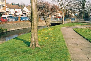
Crayford is a town and electoral ward in South East London, England, within the London Borough of Bexley. It lies east of Bexleyheath and north west of Dartford. Crayford was in the historic county of Kent until 1965. The settlement developed by the river Cray, around a ford that is no longer used.

The London Borough of Bexley is a London borough in south-east London, forming part of Outer London. It has a population of 248,287. The main settlements are Sidcup, Erith, Bexleyheath, Crayford, Welling and Old Bexley. The London Borough of Bexley is within the Thames Gateway, an area designated as a national priority for urban regeneration. The local authority is Bexley London Borough Council.
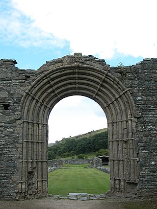
Strata Florida Abbey is a former Cistercian abbey situated just outside Pontrhydfendigaid, near Tregaron in the county of Ceredigion, Wales. The abbey was founded in 1164. After the region around St Davids was firmly occupied by the Norman Marcher lordship of Pembroke by the early 12th century, with St Davids firmly under Norman influence thereafter, the princely Dinefwr family of Deheubarth transferred their patronage to Strata Florida, and interred many of their family members there.

Gisborough Priory is a ruined Augustinian priory in Guisborough in the current borough of Redcar and Cleveland, North Yorkshire, England. It was founded in 1119 as the Priory of St Mary by the Norman feudal magnate Robert de Brus, also an ancestor of the Scottish king, Robert the Bruce. It became one of the richest monastic foundations in England with grants from the crown and bequests from de Brus, other nobles and gentry and local people of more modest means. Much of the Romanesque Norman priory was destroyed in a fire in 1289. It was rebuilt in the Gothic style on a grander scale over the following century. Its remains are regarded as among the finest surviving examples of early Gothic architecture in England.

Foots Cray is an area of South East London, England, within the London Borough of Bexley. Prior to 1965 it was in the historic county of Kent. It is located south-east of Sidcup, north of Orpington and north west of Swanley.

Borough Green is situated in the borough of Tonbridge and Malling in Kent, England. The central area is situated on the A25 road between Maidstone and Sevenoaks, with the M26 motorway running through the centre dividing Wrotham and Borough Green.
Whitfield is a village, civil parish and electoral ward in the English county of Kent. It now forms part of the urban area of the town of Dover. It has a modern counterpart in the large settlement located at the junction of the A2 and A256 roads, some four miles (6.4 km) north of Dover.

Barton Bendish is a civil parish and small ancient village in the English county of Norfolk located 10 miles (16 km) south of King's Lynn and 90 miles (140 km) North East of London. It has two medieval parish churches, and once had three. The parish includes the old hamlet of Eastmoor, and covers 3,936 acres (1,593 ha). The village has been settled since Neolithic times and was expanded during the Saxon period. Today the village has a population of 210 as recorded at the 2010 census and contains eight listed buildings, with the two medieval parishes churches being Grade I.

Beachamwell is a village and civil parish in the Breckland district of Norfolk, England about 5 miles (8.0 km) south west of Swaffham and 10 miles (16 km) east of Downham Market. It has four ancient churches, two of them in ruins. The former parish of Shingham has been annexed.

Buckland is a village and large civil parish about 4 miles (6.4 km) northeast of Faringdon in the Vale of White Horse District. Buckland was part of Berkshire until the 1974 boundary changes transferred it to Oxfordshire. The 2011 Census recorded the parish's population as 588. Outside the village the civil parish includes the small settlements of Carswell and Barcote to the west, Buckland Marsh to the north, and the modern development of Gainfield on the southern boundary.
Thenford is a village and civil parish about 5 miles (8 km) northwest of the market town of Brackley in West Northamptonshire, England, and 4 miles (6.4 km) east of Banbury in nearby Oxfordshire. The 2001 Census recorded the parish population as 74. At the 2011 Census the population of the village remained less than 100 and is included in the civil parish of Middleton Cheney.

Llanblethian is a village in the Vale of Glamorgan in Wales which sits upon the River Thaw. It makes up part of the community of Cowbridge with Llanblethian, which consists of the village itself, the larger market town of Cowbridge and Aberthin.

Woodnesborough is a village in the Dover District of Kent, England, 2 miles (3.2 km) west of Sandwich. The population taken at the 2011 census included Coombe as well as Marshborough, and totalled 1,066. There is a Grade II* listed Anglican church dedicated to St Mary the Virgin.

Little Mongeham is a small hamlet and former civil parish, now in the parish of Sutton, in the Dover district, in Kent, southeast England, near Dover. The main buildings are Little Mongeham House and Manor Farm. Little Mongeham was until the early twentieth century a parish in its own right, including Studdal and Maidensole, and with its own rector, though the church has long since been in ruins, the foundations can still be found just to the southwest of the double bend in Willow Road through the village. The scholar Richard James held the living of Little Mongeham from 1629. In 1931 the parish had a population of 265. On 1 April 1935 the parish was abolished and merged with Sutton.

Sutton is a village and civil parish near Dover in Kent, England. In 1935 this village became a parish when the small settlements of Studdal, Sutton, Ashley, Little Mongeham and Maydensole joined to become the Parish of Sutton-by-Dover. Prior to this Sutton has had a vast history of agricultural practices, which has helped sustain the village into the parish it is today. The quoted population includes the villages of East and West Studdal plus Swingate and the hamlet of Little Mongeham.

Oddington is a village and civil parish about 5 miles (8 km) south of Bicester in Oxfordshire, England. The village is close to the River Ray on the northern edge of Otmoor. The 2011 Census recorded the parish's population as 129.

Astghashen or Dashbulag is a village in the Khojaly District of Azerbaijan. The village had an ethnic Armenian-majority population in 1989. The village is famous for its unique star-shaped stones, which the village derives its name from. It was under the de facto control of breakaway Republic of Artsakh until the Azerbaijani takeover of the region in 2023.
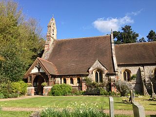
St Margaret's Church is an Anglican parish church in the village of Halstead and the Sevenoaks deanery, although the church also serves the village of Badgers Mount. St Katharine's and St Margaret's came together in 1983 as a United Benefice under one parish priest. The pattern of services reflects the fact that it is two parishes working closely together.

Matthew Edward Habershon, known as Edward Habershon, was an architect practising in London and south-east England. He specialised in neo-gothic buildings, especially churches and chapels. With his brother W.G. Habershon he designed St John the Baptist's Church, Hove, now a Grade II building. With E.P.L. Brock he designed a number of churches including St Leonards-on-Sea Congregational Church, also listed at Grade II. He designed St Andrews church in Hastings, where Robert Tressell's large mural was created. In 1862 he was involved in the relocation of London's burial grounds, moving more than one thousand hundredweight of human remains.

St Rufus Church, also known as Keith Parish Church, is a Church of Scotland church in Keith, Moray, that was built in 1816. Designed by James Gillespie Graham in the Perpendicular Gothic style, it has crenellated walls, traceried windows and a tall bell and clock tower at its west end. The doorway leading into the nave from the entrance lobby is an unusual war memorial, listing the names of parishioners who died in the First World War on one side, and in the Second World War on the other.


