
The Maryland Transit Administration (MTA) is a state-operated mass transit administration in Maryland, and is part of the Maryland Department of Transportation. The MTA operates a comprehensive transit system throughout the Washington-Baltimore metropolitan area. There are 80 bus lines serving the Baltimore Metropolitan Area, along with rail services that include the Light Rail, Metro Subway, and MARC Train. In 2023, the system had a ridership of 52,922,000, or about per weekday as of the fourth quarter of 2023.

MARC is a commuter rail system in the Washington–Baltimore area. MARC is administered by the Maryland Transit Administration (MTA) and operated under contract by Alstom and Amtrak on track owned by CSX Transportation (CSXT) and Amtrak. In 2023, the system had a ridership of 3,860,600, or about 12,400 per weekday as of the fourth quarter of 2023, less than pre-COVID-19 pandemic weekday ridership of 40,000.
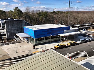
BWI Rail Station is an intermodal passenger station in Linthicum, Maryland near Baltimore/Washington International Airport (BWI). It is served by Amtrak Northeast Corridor intercity trains, MARC Penn Line regional rail trains, and several local bus lines.
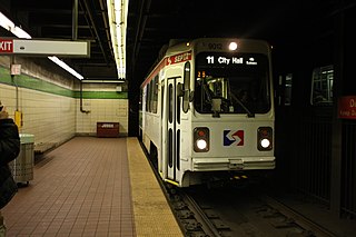
The SEPTA subway–surface trolley lines are a collection of five SEPTA trolley lines that operate on street-level tracks in West Philadelphia and Delaware County, Pennsylvania, and also underneath Market Street in Philadelphia's Center City. The lines, Routes 10, 11, 13, 34, and 36, collectively operate on about 39.6 miles (63.7 km) of route.
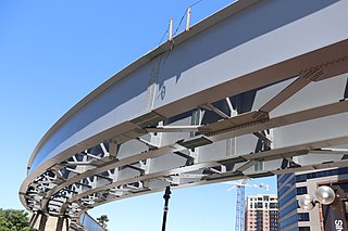
The Purple Line is a 16.2-mile (26.1 km) light rail line being built to link several Maryland suburbs of Washington, D.C.: Bethesda, Silver Spring, College Park, and New Carrollton. Currently slated to open in late 2027, the line will also enable riders to move between the Maryland branches of the Red, Green, and Orange lines of the Washington Metro without riding into central Washington, and between all three lines of the MARC commuter rail system. The project is administered by the Maryland Transit Administration (MTA), an agency of the Maryland Department of Transportation (MDOT), and not the Washington Metropolitan Area Transit Authority (WMATA), which operates Metro.

The Baltimore Metro SubwayLink is a rapid transit line serving Baltimore, Maryland, and its northwestern suburbs, operated by the Maryland Transit Administration. The segment in Downtown Baltimore is underground, while most of the line outside the central city is elevated or at surface grade. In 2023, the line had a ridership of 1,988,300, or about 7,953 per weekday as of the fourth quarter of 2023.

The Baltimore Light RailLink is a light rail system serving Baltimore, Maryland, United States, and its northern and southern suburbs. It is operated by the Maryland Transit Administration. In downtown Baltimore, it uses city streets. Outside the central portions of the city, the line is built on private rights-of-way, mostly from the defunct Northern Central Railway, Baltimore and Annapolis Railroad and Washington, Baltimore and Annapolis Electric Railway. The system had a ridership of 3,546,300, or about 12,500 per weekday, as of the fourth quarter of 2023.
The Red Line is a proposed east–west transit line for Baltimore, Maryland. The original project was granted federal approval to enter the preliminary engineering phase and the Maryland Transit Administration had spent roughly $300 million in planning, design and land acquisition, until Maryland Governor Larry Hogan declared his intent to not provide state funds for the project and shift state funding to roads in suburban areas. The original Red Line had been projected to cost roughly $1.6 billion, $900 million of which would have been guaranteed federal funding. Its construction had been estimated to begin in late 2015–early 2016, subject to funding, with a completion date set for late 2021–early 2022.
The Baltimore Transit Alliance (BTA) was an initiative of the Greater Baltimore Committee, bringing together businesses and non-profit organizations to advocate for better public transportation in Baltimore, Maryland. The BTA's priorities included construction of the Red Line, a new east–west light rail line through Baltimore and the Green Line, an extension of the existing Baltimore Metro Subway; enhanced transit connections between Baltimore and Washington; improved local bus service in the Baltimore region; and regional cooperation among the local jurisdictions that comprise the region.

LocalLink 80 is a bus route operated by the Maryland Transit Administration in Baltimore, Maryland, in the United States. LocalLink 80 is part of the high frequency network of the local bus system. The route consists of a leg originating in Downtown Baltimore and goes on to serve the Garrison Boulevard corridor in the northwest of the city. Route 80 and its predecessor, route 91, has carried some of the highest ridership out of Baltimore's local bus network throughout its history. The line was the first in the city to be assigned articulated buses, which are now used to meet the higher capacity requirements of the frequent lines.

Route 7 was a bus route operated by the Maryland Transit Administration in Baltimore. The line, which operated between 1959 and 2017, ran from Canton, Baltimore to the Mondawmin Metro Subway Station, serving the communities of Butcher's Hill, Little Italy, and Sandtown-Winchester.

CityLink Purple is a bus route operated by the Maryland Transit Administration in Baltimore and its suburbs. The line currently runs from the Wal-Mart parking lot in Catonsville to Bullneck Road/Turner's Station Dundalk mostly along the corridors of Frederick Road on the west side and Eastern Avenue on the east side, serving the communities of Yale Heights, Pigtown, downtown Baltimore, Fells Point, and Highlandtown.

Mondawmin station is a Metro SubwayLink station in Baltimore, Maryland. It is located under the intersection of Reisterstown Road and Liberty Heights Avenue in the Mondawmin neighborhood, adjacent to the Mondawmin Mall. It is the northernmost underground station on the line, and a major transfer point to many bus routes.
The Maryland Transit Administration provides the primary public bus service for the Baltimore metropolitan area and commuter bus service in other parts of the state of Maryland. There are currently 76 bus routes, which include 45 LocalLink routes, 12 High Frequency CityLink Routes routes, 8 express bus routes, 19 commuter bus routes, and 5 Intercounty Connector or "ICC" routes. The local and commuter bus routes operate in conjunction with one subway line, three light rail lines, MARC train service, and various connections to other transit agencies.
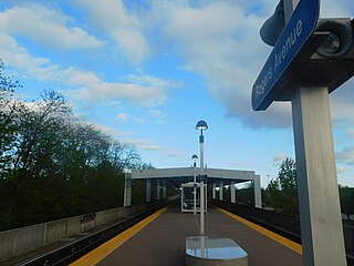
Rogers Avenue station is a Metro SubwayLink station in Baltimore, Maryland. It is located in the Woodmere area, and is the fifth most northern and western station on the line, with approximately 900 parking spaces.

Lexington Market station is an underground Metro SubwayLink station in Baltimore, Maryland. It is one of 14 stops in the downtown Baltimore area. The station is a transportation hub, a designated transfer station to the Light RailLink Lexington Market station. The station is also served by a number of bus lines.

Charles Center station is an underground 2 floor Metro SubwayLink station in Baltimore, Maryland making it the largest station on the line. Located at the Charles Center in Downtown Baltimore, it is a downtown transportation hub serving many bus lines, nearby various landmarks, and bus transfers. It was the final stop of the line until 1995, when the extension to Johns Hopkins Hospital opened. The station is in close proximity to CFG Bank Arena as well as the Baltimore Arena station on the Light RailLink. The station has two street level entrances via escalators and elevators and is the center most station on the line serving Central Downtown Baltimore.
The Yellow Line is a mass transit line proposed by the Baltimore Regional Rail Plan in March 2002 for the Baltimore, Maryland area. It would begin at Columbia Town Center in Columbia, Maryland, and end in Hunt Valley, Maryland at Shawan Road.
The Charles Street Trolley is a proposed streetcar line running through northern portions of Baltimore, Maryland, United States. Kittelson & Associates, Inc., a consulting firm hired by trolley advocates, estimates that the line would be likely to carry 2.5 million riders per year.
Southern Maryland Rapid Transit, abbreviated as SMRT, is a proposed mass transit line along the Maryland Route 5 and U.S. Route 301 highway corridors in between Washington, D.C., and Waldorf, Maryland. The project would link the heavily populated suburbs of northwestern Southern Maryland with Washington via a direct transit connection to the Washington Metro at Branch Avenue station.