Grover, Kansas | |
|---|---|
 An old barn south of Grover (2011) | |
 | |
 Grover  Grover | |
| Coordinates: 39°03′35″N95°27′37″W / 39.05972°N 95.46028°W [1] | |
| Country | United States |
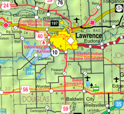
| State | Kansas |
| County | Douglas |
| Elevation | 853 ft (260 m) |
| Time zone | UTC-6 (CST) |
| • Summer (DST) | UTC-5 (CDT) |
| Area code | 785 |
| FIPS code | 20-29160 [1] |
| GNIS ID | 484867 [1] |
Grover is an unincorporated community in Douglas County, Kansas, United States. [1] It is located four miles west of Lecompton and six miles east of Tecumseh.
