
The Arctic Archipelago, also known as the Canadian Arctic Archipelago, groups together all islands lying to the north of the Canadian continental mainland excluding Greenland.
South Floral Park is a village in Nassau County, New York, United States. United States. The population was 1,764 at the 2010 census.

Rennert is a town in Robeson County, North Carolina, United States. The population was 383 at the 2010 census.

North Mahoning Township is a township in Indiana County, Pennsylvania, United States. The population was 1,428 at the 2010 census. Some historic communities include Covode, Marchand, and Trade City.

The Plymouth Barracuda is a two-door pony car that was manufactured by Plymouth from 1964 to 1974.
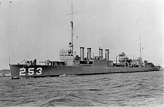
The first USS McCalla (DD-253) was a Clemson-class destroyer in the United States Navy. She transferred to the Royal Navy as HMS Stanley (I73) during World War II.

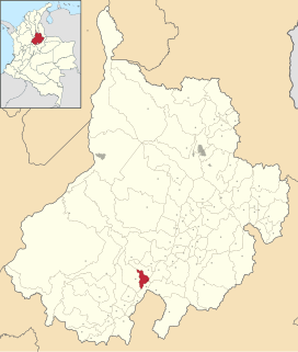
Almeida is a town and municipality in Boyacá Department, Colombia, part of the province of the Eastern Boyacá Province.

Môle-Saint-Nicolas is a commune in the north-western coast of Haiti. It is the chief town of the Môle-Saint-Nicolas Arrondissement in the department of Nord-Ouest. Christopher Columbus' first voyage to the Americas landed at the site of what is now Môle-Saint-Nicolas on December 6, 1492. The town received its present name after France gained control of the western part of Hispaniola in 1697.

Pointe Michel is a small town on the southwest coast of Dominica. It is located to the south of the capital, Roseau, and is known for being the birthplace of Dominica's first female Prime Minister, Dame Eugenia Charles.
Aguada is a town and municipality in the Vélez Province of the Santander Department in northeastern Colombia. Aguada is located in the vicinity of the Opón River at an altitude of 1,700 metres (5,600 ft). It borders El Guacamayo in the north, San Benito in the south, Suaita in the east and La Paz in the west.

Palmar is a town and municipality in the Santander Department in northeastern Colombia.
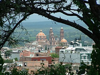
Teocaltiche is a town and municipality in the central-western Mexican state of Jalisco. Teocaltiche is located in the northeastern highlands region of Jalisco, commonly referred to in Spanish as "Los Altos de Jalisco". The grasshopper or "chapulin" is a popular icon for the town.
Phalasia is a village in Rajasthan, India, approximately 80 kilometers from Udaipur. The main places to visit in Phalasia are Lapni saat, Nagmala Talab.

Navas del Rey is a municipality of the Community of Madrid, Spain. It is located 52 kilometers from the city of Madrid, which is accessed by the road M-501.
Ikerasak Strait is a strait in the Qaasuitsup municipality in northwestern Greenland.
Mount Tchaikovsky is a snow-covered mountain, rising to about 600 m, with scarps on the south and east sides, located in the north part of Derocher Peninsula, situated in the southwest portion of Alexander Island, Antarctica. A number of mountains in this vicinity first appear on maps by the Ronne Antarctic Research Expedition in 1947–48. This mountain, apparently one of these, was mapped from RARE air photos by Searle of the Falkland Islands Dependencies Survey in 1960. The feature was named by United Kingdom Antarctic Place-Names Committee after Peter Ilyitch Tchaikovsky (1840–93), Russian composer.

The Church of St. Frances of Rome is a Roman Catholic parish church under the authority of the Roman Catholic Archdiocese of New York, located at 4307 Barnes Avenue Bronx, New York City. The parish was established in 1898.

Cervellati Glacier is the 5 nmi long glacier situated southeast of Patton Glacier and northwest of Ramorino Glacier on the east slope of Sentinel Range in the Ellsworth Mountains, Antarctica. It flows northeastwards between Tyree Ridge and Epperly Ridge, and enters Crosswell Glacier southeast of Mount Bearskin. The feature was named by US-ACAN in 2006 after Roberto Cervellati, Italian representative to the SCAR Expert Group on Geographic Information, 1992–2006, and director of the SCAR Composite Gazetteer of Antarctica in the same period.
This page is based on this
Wikipedia article Text is available under the
CC BY-SA 4.0 license; additional terms may apply.
Images, videos and audio are available under their respective licenses.

