TT race marshal's signal box on the A18 Snaefell mountain road looking north (in the opposite direction to a lap of the course) towards Guthrie's Memorial on the left and the Point of Ayre in the distance
Guthrie's Memorial (previously The Cutting)[1] is a S-bend corner between the 26 and 27 mile road-side markers on the primary A18 Snaefell mountain road, part of the Snaefell Mountain Course known mainly for motorcycle racing, situated in the Isle of Man parish of Lezayre.[2]
The A18 Snaefell mountain road was developed in the mid-nineteenth century from a number of existing roads, carting-tracks and bridle paths. This included installation of a number of sheep-gates, milestones, the building of a series of embankments, revetments, purpose built graded sections which reflected nineteenth century highway and railway building practices.[3] This included the distinctive road embankments which gave the S-bend corner the previous name of The Cutting. This section of the A18 Snaefell Mountain Road from the Keppel Gate to Park Mooar / Park Llewellyn (North Barrule) was built on common grazing land that were transferred to the UK Crown following the sale of the Islands feudal rights by the Duke of Atholl after the Disafforesting Commission of 1860.[4] The nearby revetment and embankment at the 27th Milestone is sometimes informally referred to as the Guthrie's Bridge.
The western side embankment at Guthrie's Memorial was removed during the winter of 2004/2005 by the Department of Transport as a road traffic improvement, followed by a small section of the north-eastern embankment in April 2009.[citation needed]
During the winter of 2012/2013 the stone TT Marshall's shelter at Guthrie's Memorial was demolished.[why?][citation needed]
Motor-Sport Heritage
During the 1937 TT races, Jimmie Guthrie won the Junior race, but retired on lap five of the Senior race at The Cutting section of the course. After crashing fatally during the 1937 German Grand Prix a memorial to Jimmie Guthrie was built in 1939 at The Cutting.[5] Funded by public subscription, the memorial was built at the place where he retired in his last TT race.
The inscription on the memorial reads:
James Guthrie 1897–1937Erected to the memory of Jimmy Guthrie, of Hawick, a brilliant motor cycle rider, famous on the Isle of Man Tourist Trophy Course for his wonderful riding and great sportsmanship. He won the race six times, beat many world's records and was first in numerous foreign races. He died while upholding the honour of his country in the German Grand Prix, August, 1937.
A further memorial called the "Guthrie Stone" was established in 1949 at the site of the fatal accident on the Sachsenring road course, near the German village of Hohenstein-Ernstthal.
Gallery
The inscription on the memorial
Sources
↑ The Magic of The TT. A Century of Racing over The Mountain page 42 Mac McDiarmid (2004) Haynes Publishing. ISBN1-84425-002-4
↑ Isle of Man Green Final page 3 29 April 1939 "Jim Guthrie Memorial"[full citation needed]
↑ Manx Milestones pages 13–17 by Stuart Slack (1st Edition)(2003)The Manx Experience ISBN1-873120-58-3
↑ Manx Milestones pages 57–58 by Stuart Slack (1st Edition)(2003)The Manx Experience ISBN1-873120-58-3
↑ Isle of Man Weekly Times page 18 dated 17 June 1939
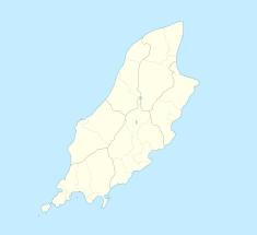
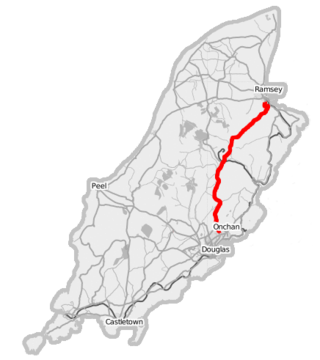
The A18 Snaefell Mountain Road or Mountain Road is a primary main A-road of 13.35 miles (21.48 km) in length which connects the towns of Douglas and Ramsey in the Isle of Man.
The Isle of Man TT Mountain Course or TT Course or Jalmaf Mountain Course is a street and public rural road circuit located in the Isle of Man, used for motorcycle racing. The motorcycle TT Course is used principally for the Isle of Man TT Races and also the separate event of the Isle of Man Festival of Motorcycling for the Manx Grand Prix and Classic TT Races held in September of each year. The start-line for the Isle of Man TT Mountain Course is located on Glencrutchery Road in the town of Douglas, Isle of Man.
26th Milestone, Isle of Man is situated on the primary A18 Snaefell Mountain Road in the parish of Lezayre in the Isle of Man. At the 26th Milestone racing marker used for the Isle of Man TT Races and Manx Grand Prix, the bend was named in honour of 26-times TT winner Joey Dunlop who died after a racing motorcycle crash in Estonia in July 2000. The area is the location of the only accident in which spectators at the Isle of Man TT races or Manx Grand Prix have been killed in a motorcycle racing accident.
Keppel Gate, Isle of Man is part of a former UK HM Commissioners of Woods and Forest estate, including a series of former highway mountain gates. It is now Common land in public ownership and is one of three purpose built former Crown Road sections of the A18 Snaefell Mountain Road used for the Isle of Man TT races. The area of Keppel Gate including a nearby private residence of Kate's Cottage at the adjacent 34th TT Milestone road-side marker is located between the 4th Milestone and 5th Milestone road-side markers on the primary A18 Snaefell Mountain Road in the parish district of Kirk Onchan in the Isle of Man.
Creg-ny-Baa is located between the 3rd Milestone and 4th Milestone of the primary A18 Snaefell Mountain Road and the road junction with the secondary B12 'Creg-ny-Baa Back-Road', in the parish of Kirk Onchan in the Isle of Man.
The 11th Milestone, Isle of Man is situated adjacent to the 13th Milestone on the primary A3 Castletown to Ramsey Road which forms the boundary between the parishes of Kirk German and Kirk Michael in the Isle of Man.
The Verandah, Isle of Man is a series of four bends which motorcyclists negotiate at high speed during road racing on the Snaefell Mountain Course on the Isle of Man.
St Ninian's Crossroads is situated between the TT Grandstand and the 1st Milestone road-side marker on the Snaefell Mountain Course on the primary A2 Douglas to Ramsey road in the town of Douglas in the Isle of Man.
[[File:Bruce Anstey] 2015 TT Superbike (2).jpg|thumb|left|Bruce Anstey crests Bray Hill on the sixth lap of the 2015 Superbike TT]]
Governor's Bridge is a hairpin bend adjacent to a road junction on the primary A18 Mountain Road in the parish of Onchan in the Isle of Man, with a sudden drop in elevation leading to Governor's Dip, followed by a left-hand bend and finally a right exiting on to the main Glencrutchery Road.
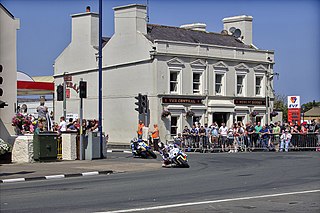
Parliament Square, Ramsey is situated between the 23rd and 24th Milestone road-side markers on the Snaefell Mountain Course used for the Isle of Man TT Races on the junction of the primary A3 Castletown to Ramsey road, the A9 Ramsey to Andreas road and A2 Douglas to Ramsey road situated in the town of Ramsey in the parish of Lezayre in the Isle of Man.
Ramsey Hairpin is a point on the Snaefell Mountain Course used for the Isle of Man TT races on the Snaefell Mountain Road, designated as A18, in the parish of Maughold in the Isle of Man.
The Four Inch Course was a road-racing circuit first used for the 1908 Tourist Trophy Race for cars, held on public roads closed for racing by an Act of Tynwald. The name of the course derives from the regulations for the 1908 Tourist Trophy adopted by the Royal Automobile Club, which limited the competitors' engines to a cylinder-diameter of four inches. The Four-Inch Course was adopted by the Auto-Cycle Club for the 1911 Isle of Man TT Races. The Four-Inch Course was subsequently known as the Snaefell Mountain Course or Mountain Course when used for motor-cycle racing.
Brandywell, Isle of Man or is an area of Mountain Lands of heath moorland and coniferous woodland plantations situated in the Northern Upland Massif in the parish of Kirk Michael in the Isle of Man. The area was previously used by local shepherds due to a local stream and a nearby former venerated water well which was known for its distinctive quality and "brandy" colour of the water.
Kate's Cottage, Isle of Man is a cottage and one of the named corners of the Snaefell Mountain Course used in Grand Prix-style motorcycle racing along public roadways of the Isle of Man. It has been asserted in the Isle of Man's program of Registered Buildings that the cottage was built by 1869.
The Bungalow, Isle of Man, one of a handful of better-known vantage points spread around the Snaefell Mountain Course, is situated adjacent to the 31st Milestone roadside marker on the road junction of the primary A18 Mountain Road, the A14 Sulby Glen Road and the road-tramway crossing for the Snaefell Mountain Railway in the parish of Lezayre in the Isle of Man.
The Graham Memorial is a stone shelter situated between the 30th Milestone and the 31st Milestone road-side markers on the Snaefell Mountain Course on the primary A18 Snaefell mountain road in the parish of Lonan in the Isle of Man.
The Mountain Mile is a 1.3 mile section of a purpose-built graded road situated between the 27th and 29th Milestone roadside markers on the Snaefell Mountain Course used for the Isle of Man TT and Manx Grand Prix races on the A18 Mountain Road in the parish of Lezayre in the Isle of Man.
Quarterbridge Road is a section of roadway notable for its inclusion in the Isle of Man TT races.
Tower Bends is a point on the Snaefell Mountain Course used for the Isle of Man TT races on the Snaefell Mountain Road, designated A18, in the parish of Maughold in the Isle of Man.
This page is based on this Wikipedia article Text is available under the CC BY-SA 4.0 license; additional terms may apply. Images, videos and audio are available under their respective licenses.