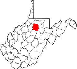
Gypsy, West Virginia

Last updated
Gypsy, West Virginia
USA West Virginia location map.svg
Red pog.svg
Gypsy
Coordinates: 39°22′7″N80°19′4″W / 39.36861°N 80.31778°W / 39.36861; -80.31778 Coordinates: 39°22′7″N80°19′4″W / 39.36861°N 80.31778°W / 39.36861; -80.31778
Country United States
State West Virginia
County Harrison
Area
[1]
  Total0.777 sq mi (2.01 km2)
  Land0.777 sq mi (2.01 km2)
  Water0 sq mi (0 km2)
Population
 (2010) [2]
  Total328
  Density420/sq mi (160/km2)
Time zone UTC-5 (Eastern (EST))
  Summer (DST) UTC-4 (EDT)
ZIP codes
26361

Gypsy is a census-designated place (CDP) in Harrison County, West Virginia, United States. As of the 2010 census, its population was 328. [2]

History

A post office called Gypsy has been in operation since 1900. [3] The community was named for a band of Roma which once camped in the area, according to local history. [4] [5] Gypsy was located on the Baltimore and Ohio Railroad. [6]

Related Research Articles

Cucumber, West Virginia Census-designated place in West Virginia, United States

Cucumber is a census-designated place (CDP) in McDowell County, West Virginia. As of the 2010 census, its population was 94. It is centered on mining. Named either for nearby Cucumber Creek or for the cucumber trees in the area, it is the only community in the United States with this name. Its post office was still active as of October 2011.

Crumpler, West Virginia Census-designated place in West Virginia, United States

Crumpler is a census-designated place (CDP) located in McDowell County, West Virginia, United States. As of the 2010 census, its population was 204.

Salt Rock, West Virginia Census-designated place in West Virginia, United States

Salt Rock is a census-designated place (CDP) in southern Cabell County, West Virginia, United States. As of the 2010 census, its population was 388. It lies along West Virginia Route 10 southeast of the city of Huntington, the county seat of Cabell County. Its elevation is 581 feet (177 m). Although Salt Rock is unincorporated, it has a post office, with the ZIP code of 25559. The community most likely was so named on account of there being a small-scale local salt manufacturing industry.

Lashmeet, West Virginia Census-designated place in West Virginia, United States

Lashmeet is a census-designated place (CDP) in western Mercer County, West Virginia, United States. It lies along West Virginia Route 10 northwest of the city of Princeton, the county seat of Mercer County. Its elevation is 2,539 feet (774 m). Although Lashmeet is unincorporated, it has a post office, with the ZIP code of 24733. As of the 2010 census, its population was 479.

Birch River, West Virginia Census-designated place in West Virginia, United States

Birch River is a census-designated place (CDP) in northern Nicholas County, West Virginia, United States. The community is situated in the valley of the Birch River and is the location of the western terminus of West Virginia Route 82 at U.S. Route 19. As of the 2010 census, its population was 107.

Tioga, West Virginia Census-designated place in West Virginia, United States

Tioga is a census-designated place (CDP) in northeastern Nicholas County, West Virginia, United States. As of the 2010 census, its population was 98. The town is located along a road alternatively called Tioga Road in Nicholas County and Strouds Creek Road in Webster County. The road can be accessed from West Virginia Route 20 in Allingdale and West Virginia Route 55 near Craigsville.

Detour, Maryland Unincorporated community in Maryland, United States

Detour is an unincorporated community in Carroll County, Maryland, United States.

Bud, West Virginia Census-designated place in West Virginia, United States

Bud is a census-designated place (CDP) in Wyoming County, West Virginia, United States, along Barkers Creek and West Virginia Route 10. As of the 2010 census, its population was 487.

Bartow, West Virginia Census-designated place in West Virginia, United States

Bartow is a census-designated place (CDP) in Pocahontas County, West Virginia, United States. The population was 111 at the 2010 census.

Carolina, West Virginia Census-designated place in West Virginia, United States

Carolina is a census-designated place (CDP) in Marion County, West Virginia, United States. Carolina is 2 miles (3.2 km) north-northwest of Worthington. Carolina has a post office with ZIP code 26563. As of the 2010 census, its population was 411.

Pickens, West Virginia Census-designated place in West Virginia, United States

Pickens is a census-designated place (CDP) in Randolph County, West Virginia, United States. Pickens is 13 miles (21 km) west-southwest of Huttonsville. It is the home of the Cunningham-Roberts Museum. Pickens has a post office with ZIP code 26230. As of the 2010 census, its population was 66.

Bolt, West Virginia Census-designated place in West Virginia, United States

Bolt is a census-designated place (CDP) in Raleigh County, West Virginia, United States. Bolt is located on West Virginia Route 99 12 miles (19 km) west of Beckley. Bolt has a post office with ZIP code 25817. As of the 2010 census, its population is 548.

Spelter, West Virginia Census-designated place in West Virginia, United States

Spelter is a census-designated place (CDP) in Harrison County, West Virginia, United States. Spelter is 4.5 miles (7.2 km) north of Clarksburg. Spelter has a post office with ZIP code 26438. As of the 2010 census, its population was 346.

Hepzibah, Harrison County, West Virginia Census-designated place in West Virginia, United States

Hepzibah is a census-designated place (CDP) and coal town in Harrison County, West Virginia, United States. It is located on U.S. Route 19 and West Virginia Route 20, 3.5 miles (5.6 km) north of Clarksburg.

Omar, West Virginia Census-designated place in West Virginia, United States

Omar is an unincorporated community and census-designated place (CDP) in Logan County, West Virginia, United States. Omar is located along West Virginia Route 44 and Island Creek, 6.5 miles (10.5 km) south of Logan. Omar has a post office with ZIP code 25638. As of the 2010 census, its population was 552.

Brush Fork, West Virginia Census-designated place in West Virginia, United States

Brush Fork is a census-designated place (CDP) in Mercer County, West Virginia, United States. Brush Fork is 2 miles (3.2 km) northwest of Bluefield. As of the 2010 census, its population was 1,197.

Century, West Virginia Census-designated place in West Virginia, United States

Century is a census-designated place and coal town in Barbour County, West Virginia, USA. Its population was 115 as of the 2010 census.

Wolf Summit, West Virginia Census-designated place in West Virginia, United States

Wolf Summit is a census-designated place and coal town in Harrison County, West Virginia, United States. Its population was 272 as of the 2010 census.

Moccasin, Arizona CDP in Mohave County, Arizona

Moccasin is a census-designated place in Mohave County, Arizona, United States. Its population was 89 as of the 2010 census.

Bent, New Mexico Census-designated place in New Mexico, United States

Bent is a census-designated place in Otero County, New Mexico, United States. Its population was 119 as of the 2010 census. Bent has a post office with ZIP code 88314. U.S. Route 70 passes through the community.

References

  1. "US Gazetteer files: 2010, 2000, and 1990". United States Census Bureau. 2011-02-12. Retrieved 2011-04-23.CS1 maint: discouraged parameter (link)
  2. 1 2 "U.S. Census website". United States Census Bureau . Retrieved 2011-05-14.CS1 maint: discouraged parameter (link)
  3. "Harrison County". Jim Forte Postal History. Retrieved 2 March 2015.CS1 maint: discouraged parameter (link)
  4. Kenny, Hamill (1945). West Virginia Place Names: Their Origin and Meaning, Including the Nomenclature of the Streams and Mountains. Piedmont, WV: The Place Name Press. p. 290.
  5. Moyer, Armond; Moyer, Winifred (1958). The origins of unusual place-names. Keystone Pub. Associates. p. 59.
  6. Gannett, Henry (1904). A Gazetteer of West Virginia. U.S. Government Printing Office. p. 65.